This item has been sold, but you can get on the Waitlist to be notified if another example becomes available, or purchase a digital scan.
1767 Isaak Tirion City Map or Plan of Lima, Peru
Lima-tirion-1767$150.00

Title
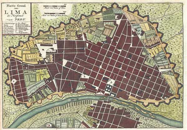
Platte Grond van Lima de Hoofstad van Peru.
1767 (undated) 7.25 x 10.5 in (18.415 x 26.67 cm) 1 : 10000
1767 (undated) 7.25 x 10.5 in (18.415 x 26.67 cm) 1 : 10000
Description
This is a c. 1767 Isaak Tirion map of Lima, Peru. The map depicts the old city center situated along the Rímac River. Encircled by walls and other fortifications, Lima, as stated in the map's title, was the capital of the Viceroyalty of Peru and had been since 1543. The city walls were built between 1684 and 1687, to guard against attack from pirates and privateers who roamed the Pacific Ocean. Eleven locations are numerically identified in and around the city, with an index located in the upper left corner, just below the title. Some of these locations include the university, cathedral, and city hall. One additional symbol is included in the index, a cross, which indicates the locations of hospitals in the city, of which there are several. While the streets may be unlabeled, the map appears to indicate that not only the city's municipal and residential buildings merited encircling within walls, but also some of the fields and orchards as well.
This map was produced c. 1767 by Isaak Tirion.
This map was produced c. 1767 by Isaak Tirion.
Cartographer
Isaak Tirion (1705 - 1765) was a Dutch publisher in Amsterdam. Born in Utrecht, Tirion quickly rose to prominence by publishing pamphlets, historical works, and most importantly, maps and atlases. He produced several atlases and Dutch town plans. His maps are mainly based on those of Guillaume de l'Isle. Tirion eventually relocated his printing house to the prestigious Kalverstraat. In his long career, he produced eight atlases in multiple editions, some of which were published posthumously until about 1784. More by this mapmaker...
Condition
Very good. Blank on verso.
References
OCLC 783842907.