1929 Omaha, Lincoln and Beatrice Railway Cyanotype Map of Part of Lincoln, NE
LincolnNebr-olbry-1929$550.00


Title
Lincoln, Nebr.
1929 (dated) 30.25 x 116.5 in (76.835 x 295.91 cm) 1 : 100
1929 (dated) 30.25 x 116.5 in (76.835 x 295.91 cm) 1 : 100
Description
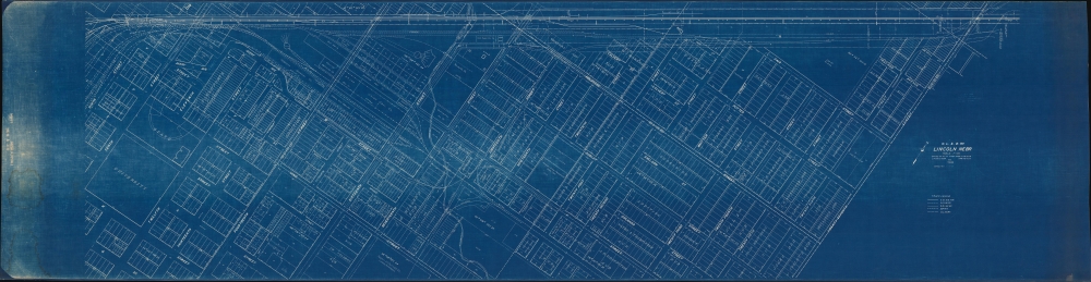
Measuring just short of ten feet, this is an impressive 1929 Omaha, Lincoln and Beatrice Railway cyanotype or blueprint map of part of Lincoln, Nebraska, including all of the modern-day City Campus of the University of Nebraska-Lincoln.
A Closer Look
The University of Nebraska appears near the left edge of the printed image, with 'State University' and 'University Addition' marking where the university had been and illustrating how it had grown. Both Memorial Stadium and the Nebraska Coliseum are illustrated and labeled, underscoring the importance of Nebraska Athletics. Both had been built only a few years before this map was printed. Curiously, no other buildings on campus are labeled, but businesses throughout the city are identified. Below the title, a notation advises the viewer that the present edition is 'Correct to June 12, 1947'.The Railroads
While this map was made by the Omaha, Lincoln and Beatrice Railway and traces its tracks through the city, four other railways are illustrated as well. These are the Chicago, Burlington and Quincy Railroad; the Chicago and North Western Railroad; the Chicago, Rock Island, and Pacific Railroad; and the Missouri Pacific Railroad. Notations differentiate between the railroads.The Omaha, Lincoln and Beatrice Railway
Founded in 1903, the Omaha, Lincoln and Beatrice Railway was created in an attempt to create passenger rail service between the three cities. The rails never extended outside of Lincoln, however it still operates as a private company to this day as a Class III switching railroad.Cyanotype: Why so Blue?
Cyanotype is a photo-reprographic technique developed in 1842 by the British astronomer John Herschel (1792 - 1871). Sometimes called a 'sunprint', the technique employs a solution of ferric ammonium citrate and potassium ferricyanide, which painted on white paper or cloth, reacts when exposed to sunlight to dye the object a brilliant blue. Areas blocked from ultraviolet exposure remain undyed and white. Herschel developed the technique to reproduce his astronomical notes, but others quickly realized that any object capable of blocking light could be used to create a cyanotype image quickly and easily. By the late 19th century, the process became popular with designers, military, architects, and engineers (blueprints), who used the cheap and effective technique to quickly and exactly reproduce images in the field. Cyanotyping is limited in that only a single copy can be made at one time, so it was only practical for short-term field work. It is also of note that cyanotypes remain extremely reactive to light and, over time, fade or degrade, making them extremely ephemeral. The process fell out of fashion in most places by the 1920s but remains in use in some parts of the world, such as India and Nepal, to this day.Publication History and Census
This map was created and published by the Omaha, Lincoln, and Beatrice Railway, on June 10, 1929, with corrections to June 12, 1947. This is the only known cataloged example of either edition of the map.Condition
Very good. Closed margin tears professionally repaired on verso. Light dampstaining in bottom left corner not effecting printed image.