This item has been sold, but you can get on the Waitlist to be notified if another example becomes available, or purchase a digital scan.
1595 Mercator Map of Lithuania (First Edition)
Lithuania-mercator-1595$625.00


Title
Lithuania.
1595 (undated) 14.5 x 17.25 in (36.83 x 43.815 cm) 1 : 3000000
1595 (undated) 14.5 x 17.25 in (36.83 x 43.815 cm) 1 : 3000000
Description
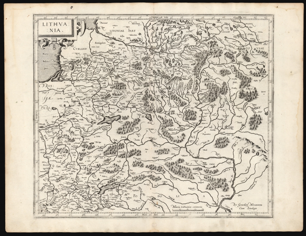
This is a superb example of Gerard Mercator's 1595 map of the Grand Duchy of Lithuania, the first issue of the first map dedicated specifically to Lithuania.
Coverage
As with most 16th-century maps of the lands between Germany and Muscovy, Mercator's work is founded on that of Bernard Wapowski, whose own maps are lost but whose work was preserved in the maps of Olaus Magnus, Münster, Vopel, Gastaldi, and Ortelius. Mercator was the first of these to focus so sharply on Lithuania, however, and his detail of the region is finer than is shown on precursor maps The map extends from the Baltic Sea, with Livonia and its capital Riga to the north, to Podolia in the south. It encompasses the Muscovite province of Smolensk to the north, and parts of Poland to the southwest. As such, the central part of the map contains all of modern-day Belarus and the southeastern part of the map is Ukraine. Mercator's map includes 15 identifiable river systems, notably the Duna, Vistula, and the Dnieper. It provided more detail for the Grand Duchy than any earlier map: there are more than 70 settlements marked, including Vilnius, Kiev, Chernobyl, Smolensk, Minsk. Forests and mountain regions are indicated pictorially.Publication History and Census
This map is thought to have been drawn by Mercator as early as 1570, but it would not be printed until 1595 in Mercator's posthumous Atlas, sive Cosmographicæ meditationes de fabrica mundi et fabricati figura. The map would continue to be printed in the Mercator/ Hondius atlas until 1634. Thereafter it was replaced with Hondius' Magni Ducatus Lithuaniae. While the present map is not difficult to find in later printings, this 1595 first edition is quite scarce, appearing in only three institutional collections at the Universitatsbibliothek Eichstatt, Nukat Union, and the Universiteit van Amsterdam.CartographerS
Gerard Mercator (March 5, 1512 - December 2, 1594) is a seminal figure in the history of cartography. Mercator was born near Antwerp as Gerard de Cremere in Rupelmonde. He studied Latin, mathematics, and religion in Rupelmonde before his Uncle, Gisbert, a priest, arranged for him to be sent to Hertogenbosch to study under the Brothers of the Common Life. There he was taught by the celebrated Dutch humanist Georgius Macropedius (Joris van Lanckvelt; April 1487 - July 1558). It was there that he changed him name, adapting the Latin term for 'Merchant', that is 'Mercator'. He went on to study at the University of Louvain. After some time, he left Louvain to travel extensively, but returned in 1534 to study mathematics under Gemma Frisius (1508 - 1555). He produced his first world map in 1538 - notable as being the first to represent North America stretching from the Arctic to the southern polar regions. This impressive work earned him the patronage of the Emperor Charles V, for whom along with Van der Heyden and Gemma Frisius, he constructed a terrestrial globe. He then produced an important 1541 globe - the first to offer rhumb lines. Despite growing fame and imperial patronage, Mercator was accused of heresy and in 1552. His accusations were partially due to his Protestant faith, and partly due to his travels, which aroused suspicion. After being released from prison with the support of the University of Louvain, he resumed his cartographic work. It was during this period that he became a close fried to English polymath John Dee (1527 - 1609), who arrived in Louvain in 1548, and with whom Mercator maintained a lifelong correspondence. In 1552, Mercator set himself up as a cartographer in Duisburg and began work on his revised edition of Ptolemy's Geographia. He also taught mathematics in Duisburg from 1559 to 1562. In 1564, he became the Court Cosmographer to Duke Wilhelm of Cleve. During this period, he began to perfect the novel projection for which he is best remembered. The 'Mercator Projection' was first used in 1569 for a massive world map on 18 sheets. On May 5, 1590 Mercator had a stroke which left him paralyzed on his left side. He slowly recovered but suffered frustration at his inability to continue making maps. By 1592, he recovered enough that he was able to work again but by that time he was losing his vision. He had a second stroke near the end of 1593, after which he briefly lost speech. He recovered some power of speech before a third stroke marked his end. Following Mercator's death his descendants, particularly his youngest son Rumold (1541 - December 31, 1599) completed many of his maps and in 1595, published his Atlas. Nonetheless, lacking their father's drive and genius, the firm but languished under heavy competition from Abraham Ortelius. It was not until Mercator's plates were purchased and republished (Mercator / Hondius) by Henricus Hondius II (1597 - 1651) and Jan Jansson (1588 - 1664) that his position as the preeminent cartographer of the age was re-established. More by this mapmaker...
Bernard Wapowski (1475-1535) a Polish cartographer, is credited with the first contemporaneous map of Poland in 1526. He was born in Wapowce near Przemyśl, but virtually nothing is known of his early life. While in Rome as part of Erasme Ciołk's Polish Embassy between 1505 and 1506, he produced his first map of Poland. He enjoyed influence there, gaining introduction to the Pope and the protection of Cardinal Peirre Jules II. Wapowski stayed in Rome for several years at the Court of the Holy See where he worked on his map of Jagellonian Poland, based on Nicolas de Cuse's 1491 map. He is thought to have drawn the Ptolemaic maps covering Poland and Kievan Rus for the 1507 and 1508 Rome Ptolemies. By 1526 Wapowski was secretary to the King Sigismund the Old. At that time, he producd a map of Poland and the Grand Duchy of Lithuania with the assistance of Nicolaus Copernicus, with whom he studied at the University of Kraków under Albert Brudzewski. The 1526 map would be Wapowski's most important: it was the first large-scale, detailed, contemporaneous map of Poland. Wapowski's maps are now all lost except in a few surviving fragments. Despite this, his work was powerfully influential in the 16th century, providing the basis for the mapping of Poland and Hungary by Münster, Ortelius, Mercator and others. He is underdstood to have had assistance from Nicolaus Copernicus. The astronomer also learned from Wapowski during their longtime friendship, producing his own map of Prussia in 1510. Wapowski also wrote a continuation of Jan Długosz's History of Poland. Learn More...
Source
Mercator, G., Atlas, sive Cosmographicæ meditationes de fabrica mundi et fabricati figura, (Duisberg: Busius) 1595.
Condition
Very good. Few small stains away from image. Centerfold reinforced at bottom margin, not impacting image. Else excellent with a bold strike and generous margins.
References
OCLC 633690814. Rumsey 10501.145 (1607) Van der Krogt, P. C. J., Koeman's Atlantes Neerlandici, (Vol. 1), 1730:1A.1. Karrow, R. W., Mapmakers of the Sixteenth Century and their Maps 56/168.