1612 Map of Northern Italy, the Alps and Southern Switzerland
Lombardy-anon-1612$6,000.00
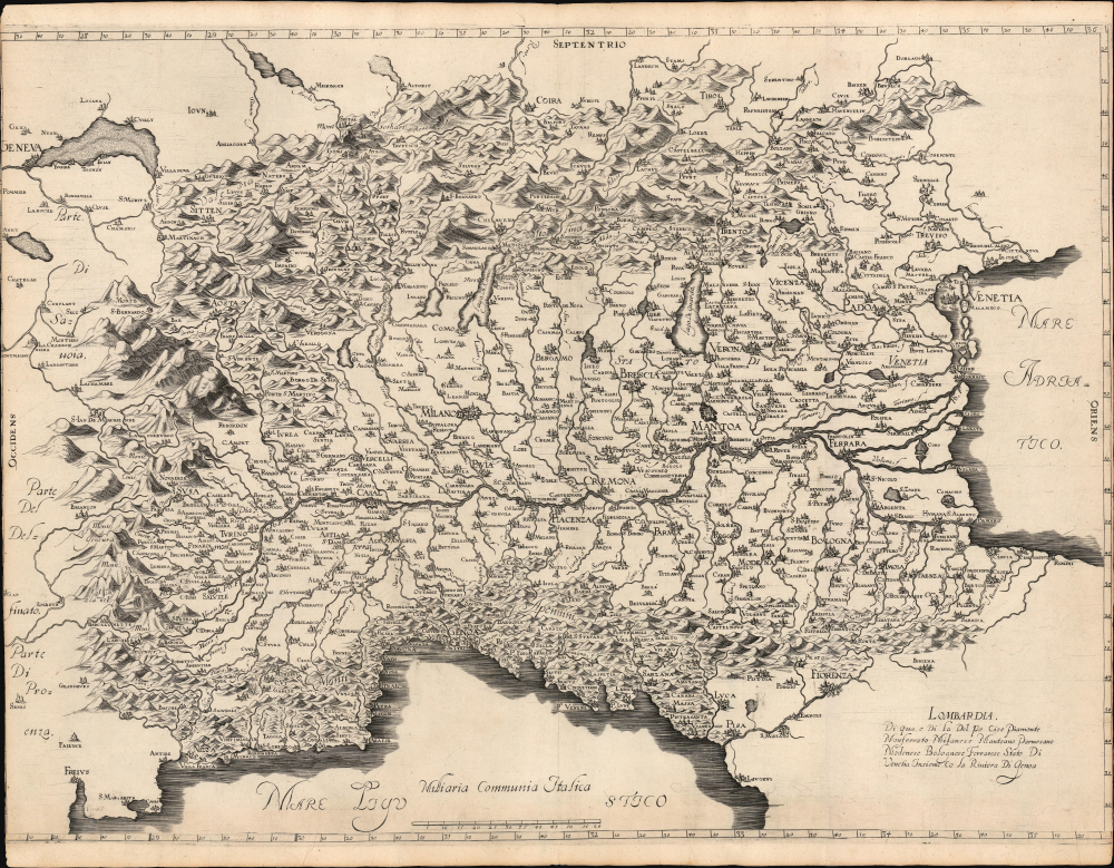

Title
Lombardia, e Di qua e Di La Del Po Cioe Piamonte Monferrato Milanese Mantoano Parmesano Modenese Bolognese Ferrarese Stato Di Venetia Insieme Co La Riviera Di Genoa.
1612 (undated) 17.756 x 24 in (45.10024 x 60.96 cm) 1 : 940400
1612 (undated) 17.756 x 24 in (45.10024 x 60.96 cm) 1 : 940400
Description
This is a rare, enigmatic, separately issued, c. 1612 Italian map of northern Italy and southern Switzerland. It details the balance of power in a region of vital strategic importance, complicated sharply by the ambitions of local powers - in particular, those of the Gonzaga Dukes of Mantua and Montferrat. While the map could have been produced as early as 1608, we suspect it is in response to the dynastic and political crisis caused by the successive deaths in 1612 of Mantua's Duke Vincenzo I Gonzaga (February 9, 1612) and his successor Francesco IV Gonzaga (December 22, 1612). These deaths set the stage for the successive northern Italian wars of the 17th century: the War of the Montferrat Succession (1613 - 1617), the Valtellina War (1620 - 1626), and the War of the Mantuan Succession (1628 - 1631).
The engraving is distinctive and informative, representing an improvement upon the maps of the previous century. The uniform 'molehill' representations of mountains characterizing late 16th-century maps are replaced with pictorial mountains varying in size and steepness. The relatively low Pennines are thus presented in sharp contrast to the Alps. The map clearly communicates the idea of the Alps as a barrier and highlights the strategic importance of the key passes.
This map represents a puzzle but rewards forensic analysis. There is nothing added to identify the mapmaker or to date the work. The scholarship surrounding the map has been unable to identify an author or propose other work by the same hand. The paper is watermarked and is consistent with Italian paper of the 17th century. Overall, it is elegant and finely engraved in a distinctive style unique to this piece - note, in particular, the gently contoured hachure rendering its Alpine topography, and the neat Roman lettering. The presence of rule lines and scratch marks on the sheet suggests a very early strike off the plate, possibly a proof. The map also reveals significant re-engraving, with some locations removed and others added. This secondary work is comparatively sloppy, a sharp contrast to the remainder of the map. These additions, and the absence of any decorative embellishment, suggest to us a painstaking work abruptly completed in haste and rushed to publication. These changes are:
By the same token, the succession crisis brought on by the Gonzagas' 1612 deaths threw control of these crucial strongpoints into question. The Habsburg emperor chose Francesco IV's brother, Ferdinando, a Cardinal, as the new duke of Mantua and Montferrat. Francesco's widow, Margaret, on the other hand, was the daughter of Duke Charles Emmanuel of Savoy, who claimed that Montferrat should pass to Francesco and Margaret's daughter Maria. Spain was faced with the possibility that Casale and even Mantua might fall into the hands of Savoy or Venice, threatening to cut Spain's connection with Northern Europe and fatally isolating Spanish Milan. When Savoy moved armies to press their claim to Montferrat, Spain thus sided with Mantua.
In the spring of 1613, Savoy laid siege to Alba, Trin, Moncalve, and Nizza Monferrato in an effort to undermine and capture Casale. All of these cities appear on the map: none of them give any indication of siege, suggesting to us that the map was produced after the crisis of succession, but before the armed conflict began.
While these passages were important trade routes for France and Venice, they were essential military assets for the Spanish: the shortest route of the 'Spanish Road' for moving armies between Habsburg Milan and Austria. The Graubünden themselves, caught in the middle, were split internally: while Protestant overall, the Valtellina Valley was predominantly Catholic and pro-Spanish. Construction of the fort not only prevented French and Venetian passage but also enforced a Spanish embargo against the Valtellina Valley, throwing the Graubünden into internal conflict between pro-Habsburg and pro-Venice elements. This ultimately exploded into the Valtellina War (1620 - 1626) in which Spanish and Papal armies would contend with France, Savoy, and Venice over control of the Spanish Road.
Overall, the shape of the lake and the positioning of the fort and the mouth of the Adda are imprecise; the presence of the fort indicates its broad importance strategically, but the imprecision of it suggests that it was peripheral to the events the map was intended to illustrate.
A Closer Look
This large copperplate map covers the watershed of the Po River, encompassing not only Lombardy, but the Pennine Mountains to the south, and the Alps to the north and west, reaching from Geneva to the Adriatic and south to encompass Liguria and the Gulf of Genoa. It centers on the Po Valley, boldly emphasizing the fortified strongpoints of Milan, Brescia, Mantua, and Casale Monferrato (Casal). To the north are the beautifully engraved Alps, particularly the strategic Alpine Valtellina, a primary corridor of the Spanish Road, extending eastward between northern Lake Como towards Borghetto and Trento.The engraving is distinctive and informative, representing an improvement upon the maps of the previous century. The uniform 'molehill' representations of mountains characterizing late 16th-century maps are replaced with pictorial mountains varying in size and steepness. The relatively low Pennines are thus presented in sharp contrast to the Alps. The map clearly communicates the idea of the Alps as a barrier and highlights the strategic importance of the key passes.
This map represents a puzzle but rewards forensic analysis. There is nothing added to identify the mapmaker or to date the work. The scholarship surrounding the map has been unable to identify an author or propose other work by the same hand. The paper is watermarked and is consistent with Italian paper of the 17th century. Overall, it is elegant and finely engraved in a distinctive style unique to this piece - note, in particular, the gently contoured hachure rendering its Alpine topography, and the neat Roman lettering. The presence of rule lines and scratch marks on the sheet suggests a very early strike off the plate, possibly a proof. The map also reveals significant re-engraving, with some locations removed and others added. This secondary work is comparatively sloppy, a sharp contrast to the remainder of the map. These additions, and the absence of any decorative embellishment, suggest to us a painstaking work abruptly completed in haste and rushed to publication. These changes are:
- Forte di Fuentes - A Milanese Habsburg fort built from 1603 - 1609 at the mouth of the Adda River to dominate the Pian di Spagna and the strategic Trivio di Fuentes, the crossroads between the Valtellina, the Valchiavenna, and the Alto Lario Valleys.
- Valenza - Located on the Po River just 12 miles east of Casale, Valenza was added at the expense of Bassignana, a larger town, the name of which was crudely effaced from the plate just below. Valenza controlled a crossing of the Po, heavily fortified by Milan-Habsburg as a counterpoint to Casale, a Gonzaga stronghold whose fortress was famed as the most advanced fortification system in Europe. The two cities created a military axis of tension, with Valenza reinforcing Spain's connection to Milan, and Casale projecting the Gonzaga Dukes' power in Montferrat whilst defending their interests against all comers, not excluding Milan despite both Duchies' alignment with the Habsburgs.
- Madruccio - Located just north of Lago di Garda, this is Castel Madruzzo, the residence of the Prince-Bishops of Trento. Madruzzo was loosely aligned with Habsburg interests and, although not directly in the Valtellina Valley, did lie along another Alpine corridor between Austria and Northern Italy and held high strategic value within the Imperial-Spanish (Habsburg) logistical network.
- Milano, Mantua, Brescia, Peschiera, and Casale - While there is no clear evidence these cities were re-engraved, they are presented in a distinctly different style that highlights their fortifications. They are discussed in greater detail below.
Source: Mercator
The anonymous mapmaker has relied heavily on Gerard Mercator's 1595 Italia for the placement of most rivers and towns, and the delineation of the coastlines. This is evident in the delineations of the Ligurian and Venetian coastlines, the Po and its network of tributaries, and a preponderance of the cities. In several cases (notably the Turin and Milan regions), the mapmaker adds detail from Mercator's more regional maps. It is on this framework that new details (particularly the Forte di Fuentes) have been added.Gonzaga Dukes of Mantua and Montferrat, and the War of the Montferrat Succession
It is tempting to view the northern Italian political environment in the light of the monolithic conflicts between the Spanish Habsburgs and their French and Venetian adversaries, but the local realities were less cut and dried. The Dukes of Mantua and Montferrat were aligned with the Habsburgs and Milan. Rivalries nonetheless remained. When Duke Vincenzo I began building Casale's mammoth, six-sided fortress, it was just as much positioned to oppose Milanese influence as it was to protect against a Savoyard threat. Despite being smaller in power and prestige than Spain, France, or Venice, the Duchies of Mantua and Montferrat were able to exercise disproportionate influence and maintain a level of independence due to the sophistication of their fortresses.By the same token, the succession crisis brought on by the Gonzagas' 1612 deaths threw control of these crucial strongpoints into question. The Habsburg emperor chose Francesco IV's brother, Ferdinando, a Cardinal, as the new duke of Mantua and Montferrat. Francesco's widow, Margaret, on the other hand, was the daughter of Duke Charles Emmanuel of Savoy, who claimed that Montferrat should pass to Francesco and Margaret's daughter Maria. Spain was faced with the possibility that Casale and even Mantua might fall into the hands of Savoy or Venice, threatening to cut Spain's connection with Northern Europe and fatally isolating Spanish Milan. When Savoy moved armies to press their claim to Montferrat, Spain thus sided with Mantua.
In the spring of 1613, Savoy laid siege to Alba, Trin, Moncalve, and Nizza Monferrato in an effort to undermine and capture Casale. All of these cities appear on the map: none of them give any indication of siege, suggesting to us that the map was produced after the crisis of succession, but before the armed conflict began.
Protecting the Spanish Road
On the eastern shore of Lake Como, at the mouth of the River Adda is Forte di Fuentes. Construction of the fort began in 1603 at the order of Don Pedro Enriquez de Acevedo, Count of Fuentes, the Spanish governor of Milan. His aim was to control the Valtellina Valley (extending eastward from the northern part of Lake Como towards Bormio and Trento), a key crossroads between the Alpine valleys passing to the Swiss territories of Graubünden, or the Gray Leagues.While these passages were important trade routes for France and Venice, they were essential military assets for the Spanish: the shortest route of the 'Spanish Road' for moving armies between Habsburg Milan and Austria. The Graubünden themselves, caught in the middle, were split internally: while Protestant overall, the Valtellina Valley was predominantly Catholic and pro-Spanish. Construction of the fort not only prevented French and Venetian passage but also enforced a Spanish embargo against the Valtellina Valley, throwing the Graubünden into internal conflict between pro-Habsburg and pro-Venice elements. This ultimately exploded into the Valtellina War (1620 - 1626) in which Spanish and Papal armies would contend with France, Savoy, and Venice over control of the Spanish Road.
Overall, the shape of the lake and the positioning of the fort and the mouth of the Adda are imprecise; the presence of the fort indicates its broad importance strategically, but the imprecision of it suggests that it was peripheral to the events the map was intended to illustrate.
Milan, Brescia, Mantua
Essential to understanding the map is noting the way key cities - Milan, Mantua, Brescia, Casale, and to a lesser extent Peschiera are presented. All are centrally located at the heart of the map. Unlike the other cities, including major fortified centers like Bologna, each is disproportionately large, with its fortifications heavily engraved and emphasized. These were major foci of power in the heart of Lombardy:- Milan was the epicenter of Spanish Habsburg influence in northern Italy. It was key to maintaining control of the Spanish Road - the key overland route connecting Habsburg Spain with its territories in the Netherlands and Austria.
- Brescia was a Venetian Terraferma possession on the frontier with Spanish Milan. It was both a staging point and a logistical hub for Venetian military operations in the region, and was a trade link to Valtellina Valley.
- Mantua while an independent duchy under the Gonzagas, bordered both Venetian and Imperial territories. While aligned with the Habsburgs, Mantua avoided direct conflict with nearby Venice, and particularly in their dual role as dukes of Montferrat, they actively rivaled Spanish Milan.
- Casal (as here), or more properly Casale Monferrato, was one of the most highly fortified cities in Europe, and was the seat of the Duchy of Montferrat, controlled by the Dukes of Mantua. It defended both Montferrat's access to the River Po and posed a counterpoint to the nearby Spanish-Habsburg stronghold of Valenza, just 12 miles downstream.
- Peschiera was a highly fortified Venetian city at a geographic chokepoint at the southern tip of Lake Garda, making it crucial for logistics, troop movement, and regional defense along the Venetian-Spanish frontier, in tandem with Brescia.
Dating
It is likely that this map was produced between 1608 and 1620, we think 1612. Davoli, Sanfelici, and Zanasi give a 'post 1603' based on the presence of Forte di Fuentes. Emilio Moreschi proposes a date of 1610; Stefano Bifolco suggests 1608. This latter coincides with Magini's 1608 wall map of Italy, whose inclusion of Forta di Fuentes appears to be the first such on a dated map. It must be said that Magini's delineation of Lake Como, and his placement of the Forte di Fuentes on that map, is far more correct than is evident here, thus underscoring that the author did not have access to that work. We believe it to have been issued around 1612 to illustrate the regional balance of power in the wake of the death, heirless, of Francesco IV Gonzaga, Duke of Mantua and Montferrat, and the power vacuum that event fostered.Publication History and Census
The author and engraver of this map are unknown. It was produced in Italy c. 1612, separately published, with no known association with a bound work. A few examples, so we understand anecdotally, have appeared in the Italian market, but there are no price records from dealers' catalogs or auctions. We are aware of only two institutional examples: Bibliothèque Nationale de France and New York State Library.Condition
Good. Printed to 17th century Italian watermarked paper, extended prior to printing. Trimmed to border on right; left border trimmed, with no cartographic loss. The lower border is missing roughly 1 cm between the scale and the graticules along the lower border with no loss of geographic content. The trim is nearly invisible and as enigmatic as the reset of the map. We suspect this work was done by an early, perhaps contemporaneous, binder to make the map fit into a report or composite atlas. Else a beautiful example with a bold, sharp strike.
References
OCLC 1418340655. Davoli, Z., Sanfelici, R., Zanasi, S., Terre di Langobardia: La 'Lombardia', Il Corso del Po e il Ducato Estense Nell' Antica Cartografica a Stampa 1520 - 1796, (Modena: Panini) 2004. Moreschi, E., La Lombardia e la Bergamasca Rappresentazioni cartografiche sec. XVI-XIX (Bergamo: Ateneo di Scienze, Lettere ed Arti di Bergamo) 2005. Arnold, Thomas F., 'Gonzaga Fortifications and the Mantuan Succession Crisis of 1613-1631', Mediterranean Studies, (Penn State University Pres) Vol. 4, 1994, pages 113 - 130.