This item has been sold, but you can get on the Waitlist to be notified if another example becomes available, or purchase a digital scan.
1920 Bacon Pocket Map of London, England and Environs
London-bacon-1920$175.00

Title
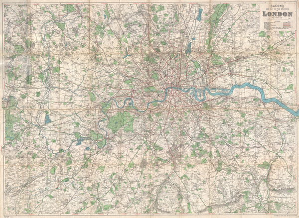
Bacon's New Map of the Environs of London.
1920 (dated) 29 x 39 in (73.66 x 99.06 cm)
1920 (dated) 29 x 39 in (73.66 x 99.06 cm)
Description
An extremely attractive folding pocket map of London, England and environs issued in 1920 by Bacon & Co. Covers the greater London area from Amersham in the northwest to Seven Oaks in the southeast and from Worplesdon in the southwest to Daguam Park in the northeast. Shows the course of the Thames River, streets, train and tram routes, bus lines, parks, roads, and important building where notable. Mounted on original linen.
Cartographer
George Washington Bacon (1830 - 1922) was a London based book and map publisher active in the mid to late 19th century. Bacon's firm G.W. Bacon and Co. purchased the plates created by Edward Weller for the Weekly Dispatch Atlas then modified and updated them for several of their own important atlases, including The New Ordnance Atlas of the British Isles. In 1893, Bacon & Co. acquired the map publishing business of J. Wyld. Then, around the turn of the century, Bacon & Co. itself was folded into the Scottish publishing house of W.& A.K. Johnston. More by this mapmaker...
Condition
Very good condition. Minor wear on original fold lines - especially at intersections. Folds into original linen binder.
References
Surrey History Center, M 00524.