This item has been sold, but you can get on the Waitlist to be notified if another example becomes available, or purchase a digital scan.
1795 Bowles Pocket Map of London
London-bowles-1795$325.00

Title
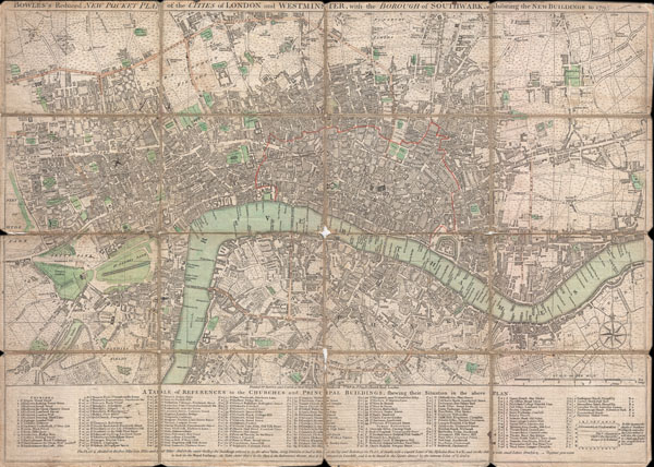
BOWLES'S Reduced NEW POCKET PLAN of the CITIES of LONDON and WESTMINSTER, with the BOROUGH of SOUTHWARK, exhibiting the NEW BUILDINGS to the YEAR 1795.
1795 (dated) 15.5 x 21.75 in (39.37 x 55.245 cm)
1795 (dated) 15.5 x 21.75 in (39.37 x 55.245 cm)
Description
This is a rare 1795 folding pocket map or street plan of London, England by Carrington Bowles. Covers London on both sides of the Thames River from Hyde Park in the west to White Horse Street in the East and from Lambeth in the south to Islington in the North. Offers superb detail throughout often noting individual buildings, gardens, and estates. Table along the bottom notes principle buildings and churches. Bowles first issued this plan in 1777 and updated it regularly to the end of the 18th century. This edition of the map was issued shortly after Bowles's death by his firm, Bowles and Carver, from their offices at No. 69 St. Paul's Church Yard, London.
Cartographer
The Bowles Family (fl. c. 1714 - 1832) were publishers and map sellers active in London from c. 1714 to c. 1832. The firm, under Thomas Bowles (fl. 1714 - 1763), John Bowles (1701 - 1779), Carrington Bowles (1724 - 1793), and as Bowles and Carver (fl. 1794 - 1832), produced a massive corpus of work that included numerous atlases, pocket maps, and wall maps. The Bowles publishing tradition was kept alive for four generations, starting with Thomas Bowles, a print engraver active in the late 17th century. His son, Thomas Bowles II, produced the firm's first maps at St. Paul's Churchyard, London. Thomas's brother, John Bowles (a.k.a. 'Old John Bowles' or 'Black Horse Bowles'), was also an active publisher established at no. 13 Cornhill. He is credited as one of the first publishers of William Hogarth's works. There, John's son, Carrington Bowles, was introduced to the trade. Carrington took over the Cornhill bookshop and eventually merged it with his uncle's shop in St. Paul's Churchyard. On Carrington's 1793 death, the business was passed to his son Henry Carrington Bowles (1763 - 1830), who partnered with his father's former apprentice Samuel Carver (1756 - 1841), renaming the firm 'Bowles and Carver'. Under this imprint, the firm continued to publish maps and atlases until 1832. Henry Carrington Bowles died in 1830, but Samuel Carver, himself in advanced years and poor health, kept it going for another 2 years before closing the business. More by this mapmaker...
Condition
Good condition. Dissected into 16 sections and mounted on linen. Original linen backing exhibits considerable wear and is splitting in places. In some places, particularly at the fold intersections at the center of the map, there is minor loss - see image. Else a very nice example.
References
Howgego, James L., Printed Maps of London circa 1553 - 1850, 158-168.