This item has been sold, but you can get on the Waitlist to be notified if another example becomes available, or purchase a digital scan.
1582 Braun and Hogenberg Map of London
London-braunhogenberg-1574$3,750.00

Title
Londinum Feracissimi Angliae Regni Metropolis.
1574 (undated) 13.5 x 18.5 in (34.29 x 46.99 cm)
1574 (undated) 13.5 x 18.5 in (34.29 x 46.99 cm)
Description
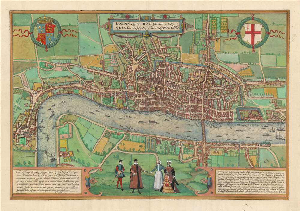
This is Georg Braun and Franz Hogenberg's plan of London, the first surviving, single-sheet, printed map of London. The significance of this seems not to have been lost on the authors, who made it the first plan in their Civitatis Orbis Terrarum, the first published collection of city plans and views. It is one of the few acquirable depictions of the city made before the Great Fire of 1666 (Howgego notes that it was the Great Fire itself, and the problems attendant to land ownership and rebuilding that led to proper surveys of the city in the first place.)
'Steelyards' was an Anglicization of 'Stapelhof,' and it was a combined stronghold, warehouse, counting-house, and residency for the Hanseatic League, whose traders spanned northern Europe reaching back to the Middle Ages. It represented a key link between London, Hamburg, Cologne, and other European ports. The Hansa were allowed liberty to trade throughout England, in return for which they maintained London's Bishopsgate, and pledged to provide a third of its defenders in times of war. The Hansa imported foodstuffs as well as the material for shipbuilding and maintenance. As London grew in importance, the positioning of Stilliards would become an impediment: larger ships could not pass the bridge to upstream warehouses. By the time this plan was made, the Hansa were losing their grip on London's trade in favor of indigenous traders, and indeed, Elizabeth I would command the Hansa to leave London completely in 1597.
A Closer Look
London here is represented as it was during the lifetime of Elizabeth I, and William Shakespeare - the beginnings of the Southwark theater district can be seen, although the locales featured there on this plan are bull and bear baiting rings. To the north, development beyond the city's medieval walls can be seen beyond Aldgate. Though not named, the Strand can be seen as the primary link between the city proper and Westminster via Charing Cross. Along the river, named palaces of nobility can be seen with their water gates facing the waterfront.A Classic, Decorative Engraving
Typical of Braun and Hogenberg's views, the city here is laid out as a plan, but the buildings and surrounding landscape are presented in elevation - thus giving the impression of a bird's eye view, even to the extent of detailing gardens (including the shadows cast by trees) and showing bustling river traffic. Also, as with other Braun and Hogenberg plans, the artists have included four figures in the foreground: a nobleman and woman, with their attendant maid and footman (he, armed with a sword and buckler), each dressed in the styles of the period appropriate to their positions.London as an International Trading Center
The wonder of the city, at the time, was its rapid growth and fruitfulness (the descriptive word in the title, 'Feracissimi,' means 'most fruitful.' The Latin text on the lower left praises the city for its churches and palaces and the excellence of its men of art and science. It notes the city's position on the Thames, and that it receives via the Thames 'the wealth of the whole world.' The significance of London as a trade city may be additionally emphasized by the text at the lower right praising the Hansa Confederation, whose guild hall, the Stilliards, is depicted prominently on the north shore of the Thames just upstream of the Bridge. Stilliards is now buried under Cannon Street Station, but it represented a foothold in London of the most powerful foreign element in Medieval London.'Steelyards' was an Anglicization of 'Stapelhof,' and it was a combined stronghold, warehouse, counting-house, and residency for the Hanseatic League, whose traders spanned northern Europe reaching back to the Middle Ages. It represented a key link between London, Hamburg, Cologne, and other European ports. The Hansa were allowed liberty to trade throughout England, in return for which they maintained London's Bishopsgate, and pledged to provide a third of its defenders in times of war. The Hansa imported foodstuffs as well as the material for shipbuilding and maintenance. As London grew in importance, the positioning of Stilliards would become an impediment: larger ships could not pass the bridge to upstream warehouses. By the time this plan was made, the Hansa were losing their grip on London's trade in favor of indigenous traders, and indeed, Elizabeth I would command the Hansa to leave London completely in 1597.
The Source Plan
Although the first state was printed in 1572, it is based on an earlier work that has not survived in completion. Saint Paul's is shown with its spire intact: this burned in 1561, and Suffolke Place has not yet been renamed to York Place, which occurred in 1557. It is thought to have been reduced from a now-lost fifteen-sheet plan of the city, the so-called 'copperplate map' of which only three plates now survive. The authorship of the 'copperplate map' is not known, but it has been speculated that the Hansa in London played some part in its production, even commissioning the work - resulting in the laudatory paragraph to the Stillyards and the Hansa that survives on the present engraving.Publication History and Census
This plan was engraved by Franz Hogenberg for inclusion in the first, 1572 edition of Braun and Hogenberg's Civitatis Orbis Terrarum. The present example corresponds to Howgego's 1574 second state of the plan (with the change of the name 'Westmester' to 'Westmunster,' and depicting the trapezoidal Royal Exchange). The map appeared in every Civitates edition and is well represented in institutional collections.CartographerS
Georg Braun (1541 – March 10, 1622) was a German deacon, viewmaker, and typo-geographer based in Cologne. Along with Franz Hogenberg (1535 - 1590), Braun is best known for his publication of the highly influential city atlas Civitates Orbis Terrarum. The six volume work, with some 546 views, was published between 1572 and 1617 and intended a companion to Abraham Ortelius' Theatrum Orbis Terrarum - thus certain obvious stylistic similarities. In compiling the Civitates Braun took on the role of editor while most of the engraving work was completed by Franz Hogenberg. Braun died, as he was born, in Cologne. More by this mapmaker...
Franz Hogenberg (1535 - 1590), often called 'Master Franz,' was a Flemish engraver active in the late 16th century. Hogenberg was born in Mechelen, the son of Nicolas Hogenberg, where he trained under the cartographer H. Terbruggen. He later relocated to Antwerp where he achieved success as an engraver, working with Abraham Ortelius, Hieronymus Cock, and others. In 1568, his name appeared on the list of those banned from the Netherlands by the Duke of Alva, forcing his family to flee to London. There he engraved for Christopher Saxon's Atlas of England and Wales. By 1570 he emigrated to Germany settling in Cologne. In Cologne he married his second wife, Agnes Lomar, with whom he had six children. In 1579 the couple were briefly imprisoned for holding illicit secret religious meetings, but were released in short order. Along with German cleric George Braun (1541 – March 10, 1622), Hogenberg issued the highly influential city atlas Civitates Orbis Terrarum. The six volume work, with some 546 views, was published between 1572 and 1617 and intended a companion to Abraham Ortelius' Thatrum Orbis Terrarum - thus certain obvious stylistic similarities. In compiling the Civitates Hogenberg took on the role of engraver while most of the editing was left to Georg Braun. Hogenberg died in Cologne, Germany, before the Civitates was completed. After his death, Hogenberg's work was continued by his son, Abraham Hogenberg, who, under the direction of Agnes, his mother, took over his father's enterprise at just 20. Learn More...
Source
Braun, G. and Hogenberg, F., Civitates Orbis Terrarum, (Antwerp) 1574.
The Civitatus Orbis Terrarum is an 6-volume atlas of cities, or town book, compiled and written by George Braun, Canon of Cologne Cathedral and Franz Hogenberg. Braun and Hogenberg gathered together vast amounts of information and draft plans to produce over 500 city views/maps published in six parts between 1572 and 1617. Most of the town views and plans were engraved by Simon van den Neuvel (Novellanus) and Frans Hogenberg, many after drawings by Joris Hoefnagel. The Civitatus Orbis Terrarum was printed in Cologne, but in the Flemish style after Abraham Ortelius, the preeminent cartographer of the period. The text throughout is the work of Braun. The work proved to be a great success, reflecting the period's greater fascination with notable metropolises than with national boundaries. After the initial publication of volume 1, the popularity of the led to a second volume. In the introduction to volume 2, Braun requests that those who live in cities not represented, sent details of their own metropolises. This led to the publication of volumes 3, 4, and 5. Volume 6, the last, did not appear until 1617 under Franz Hogenberg's son, Abraham Hogenberg. The volumes include
- Civitates orbis terrarium, first edition 1572.
- De praecipuis, totius universi urbibus, liber secundus, first edition 1575.
- Urbium praecipuarum totius mundi, liber tertius, first edition 1581.
- Urbium praecipuarum totius mundi, liber quartus, first edition 1588.
- Urbium praecipuarum mundi theatrum quintum, first edition 1596.
- Theatri praecipuarum totius mundi urbium liber sextus, first edition 1617.
Condition
Very good. Few marginal mends, else excellent. Fine hand color.
References
OCLC 698868629. Goss, J.The City Maps of Europe, pl. 31; Whitfield, P. London A Life in Maps, p. 35; Howgego, J. Printed Maps of London, pp. 9-10, no. 2.