This item has been sold, but you can get on the Waitlist to be notified if another example becomes available, or purchase a digital scan.
1866 Cassell Case Map of London, England (monumental)
London-cassell-1866$3,000.00

Title
London.
1866 (undated) 56 x 77 in (142.24 x 195.58 cm) 1 : 594000
1866 (undated) 56 x 77 in (142.24 x 195.58 cm) 1 : 594000
Description
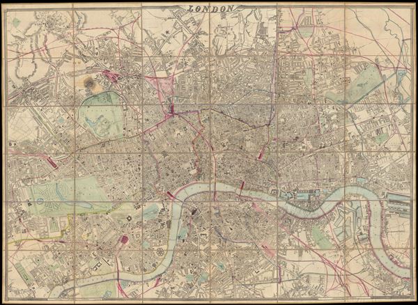
A remarkable and monumental map of London, this is Weller and Cassell's 1866 wall map of London. When it was first issued in 1861 this was the largest scale map of London yet produced. Cassell was justly proud of his map bragging, 'as well as being the largest, [Cassell's Map of London] is universally admitted to be the best map of London ever produced.' The map covers from Upper Holloway to Poplar and From Kennington to North Kensington. On a scale off roughly 9 miles to the inch, Cassell's map offers stupendous detail throughout, noting all streets, as well as rail lines, important buildings, gardens and parks, and notes o new constructions. This last is particularly significant in regard to this map, as it was updated extensively by John Dower in 1866 to reflect numerous major civic projects and improvements then in progress. Dower's revisions, reflected in this edition included 'upwards of 2000 improvements and alternations … to the plates, including the addition of 9000 new street names.' Among these are a several highly anticipated projects including the 'New Blackfriars Bridge,' the 'Waterloo and Whitehall Railway Bridge,' the Holborn Viaduct,' and the 'Thames Subway Intended,' among others. Cassell issued this map to compete with Edward Stanford's similarly large scale 'Stanford's Library Map of London.' The Cassell map is larger both in dimensions and scale, but the Stanford map covers a great area. As London map scholar Ralph Hyde points out 'both maps are indispensable for any study of London during this period.'
Cassell working with engraver and cartographer Edward Weller originally published this map in segments issued weekly in the Weekly Dispatch. It was also published in Cassell's Family Paper, Cassell's British Atlas, and issued independently both on rollers and segmented (as the present example) on linen. The present example is the 1866 (Dower Revision) 6th recorded state. This is the largest original map of Victorian London obtainable.
Cassell working with engraver and cartographer Edward Weller originally published this map in segments issued weekly in the Weekly Dispatch. It was also published in Cassell's Family Paper, Cassell's British Atlas, and issued independently both on rollers and segmented (as the present example) on linen. The present example is the 1866 (Dower Revision) 6th recorded state. This is the largest original map of Victorian London obtainable.
CartographerS
John Cassell (January 23, 1817 - April 2, 1865) was an English entrepreneur, coffee trader, and publisher active in London during the middle part of the 19th century. Cassell was born at the Ring o' Bells Inn, which his father owned, in Manchester, England. His father unfortunately died young leaving his wife and children in poverty. Cassell took work as a child laborer and was in time apprenticed as a joiner. Around 1833 he fell in with the temperance movement - possibly a response to early unpleasant memories from the Ring o' Bells. He traveled on foot form Manchester to London preaching the importance of Temperance to anyone who would listen. His work with this unfortunate movement led to his first publications, the 'Teatotler Times', the 'Standard of Freedom' and the 'Working Man's Friend'. Later he began issuing 'Cassell's Magazine'. In addition to his publishing concerns, Cassell owned and operated a wholesale coffee and tea business and a coffee-house on Fenchurch Street known as a meeting place for writers, artists, and other liberal reformers including George Cruickshank, William and Mary Howitt, and Ellen Wood. In 1854 Cassell's publishing business was taken over by Thomas Galpin (1828 - 1910) and George Petter (1824 - 1888) although Cassell stayed on as an editor, later buying in once again as a full partner. Despite a rich life and a promising career, Cassell died at just 48 of a cancerous tumor. He is buried at Kensal Green Cemetary. The company, 'Cassell, Petter & Galpin', which at the time of his death employed 500 people, continued to prosper under the management of the remaining partners, Petter and Galpin. More by this mapmaker...
Edward Weller (July 1, 1819 - 1884) was a cartographer and engraver based in London. Weller was a nephew of another well-known map publisher Sidney Hall (1788 - 1831), who gave him 50 Pounds to pay his apprenticeship fees. He engraved for many prominent mapmakers and was active enough in the community to be recommended for membership to the Royal Geographical Society in 1851 on the recommendation of John Arrowsmith, among others. He eventually inherited the Sidney Hall map business which led him to follow Arrowsmith as the unofficial geographer to the Royal Geographical Society. Weller was among the first map printers in London to embrace lithography. His best known work appears in Cassell's Weekly Dispatch Atlas, published in monthly segments for subscribers of the 'Weekly Dispatch' newspaper. This collection of maps eventually grew to include much of the known world. Published in various editions from 1855 through the early 1880s. Weller died in May of 1884, leaving behind a successful business and an unhappy widow. His son, Francis Sidney Weller (1849 - 1910), followed in his father's footsteps and continued the family map business. The atlas Mackenzie's Comprehensive Gazetteer of England and Wales was published in 1894 and bore F. S. Weller's signature on the maps. Learn More...
John James Dower (June 1, 1825 - 1901) was a well-respected mapmaker, print seller, and publisher based in London, England. Dower is the heir to the more prominent London engraver and mapmaker John Crane Dower (1791 - 1847). Dower worked with many prominent middle to late 19th century London map publishers including Weller, Cassell, Bacon, Petermann, and others. He was elected to the Royal Geographical Society in 1854. Dower also published on maps his own account including one atlas and various school geographies. In addition to his cartographic work, Dower is well known as an engraver of military scenes. Learn More...
Condition
Very good. Dissected and mounted on linen. Comes with custom made book box.
References
Hyde, Ralph, Printed Maps of Victorian London, 1851 - 1900, no. 73(6), also pages 15-16.