This item has been sold, but you can get on the Waitlist to be notified if another example becomes available, or purchase a digital scan.
1834 Cruchley Pocket City Map or Plan of London, England
London-cruchley-1834$475.00

Title
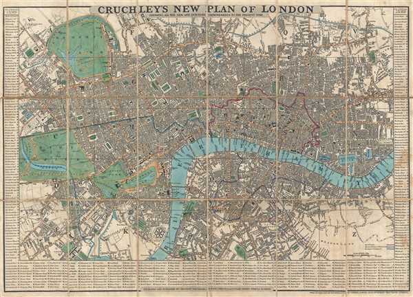
Cruchley's New Plan of London. Shewing All the New and Intended Improvements to the Present Time.
1834 (dated) 17.5 x 24.25 in (44.45 x 61.595 cm) 1 : 16200
1834 (dated) 17.5 x 24.25 in (44.45 x 61.595 cm) 1 : 16200
Description
This is an 1834 edition of George Frederick Cruchley's famous city map or plan of London, England. The map depicts the city from Hyde Park to the London Docks and from Regent's Park and the Regents Canal to Kennington and Walworth. Highly detailed, myriad streets and other locations are labeled throughout London. Buckingham Palace, St. James's Palace, the Houses of Parliament, Westminster Abbey, and the Tower of London are among the sites specifically identified. The detail even extends to labeling locations within the city parks. The City of London, the City and Liberties of Westminster, and the Borough of Southwark are differentiated through the use of thick colored lines overlaid on the map. Bordered by a street index, each street is listed with a letter, which corresponds to a letter on the map's grid.
The early 19th century was a period of extraordinary growth for London as the industrial revolution motivated thousands to relocate to the teaming metropolis. The wealth generated by a global empire combined with a population explosion led to greater demand for a modern urban infrastructure. Cruchley aptly names this his 'New Plan of London' and takes pains to note that it shows all 'new and intended improvements.' From railways and canals, to new bridges, and advances in sewage systems, Cruchley's London was transforming into a modern global megapolis.
Cruchley first issued this map in 1827, with more than 18 subsequent editions, most of which included significant updates throughout. The present example is the 7th edition.
Cartographer
George Frederick Cruchley (April 23, 1797 - June 16, 1880) was a London based book and map seller active in the middle part of the 19th century. Cruchley began his cartographic career as an apprentice at the venerable Aaroon Arrowsmith firm. Many of Cruchley's earliest maps bear the words 'From Arrowsmith's' on the imprint. In 1844, Cruchley acquired the massive stock of the important early 19th century firm of John Cary. Cruchley published his own maps as well as reissues of Cary's stock well into the 1870s. He is best known for his detailed plans of London, which in recent years have become increasingly scarce and desirable. Cruchley was based in London on 38 Ludgate Street until 1834 when he moved his offices to 81 Fleet Street. Shortly before his death in 1880 Cruchely auctioned (Hodgson's Auctions, Jan 16, 1877) his entire stock. Many of his map plates were thusly acquired by 'Gall and Inglis' who continued the Cruchley tradition well into the early 20th century. Cruchley's son, also George Frederick (1837 - 1882), continued to work as a book and map seller until his death. More by this mapmaker...
Condition
Very good. Dissected and mounted on silk in 18 panels. Comes with original carboard sleeve.
References
Howgego No. 307.