This item has been sold, but you can get on the Waitlist to be notified if another example becomes available, or purchase a digital scan.
1706 La Feuille Map or City Plan of London, England
London-lafeuille-1706$100.00

Title
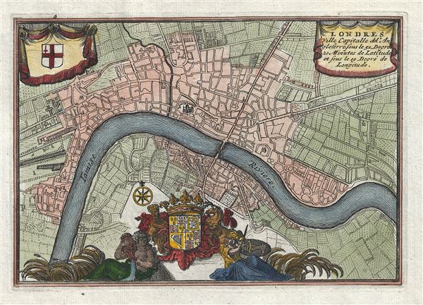
Londres Ville Capitalle de l'Angleterre.
1706 (undated) 5 x 7 in (12.7 x 17.78 cm) 1 : 63360
1706 (undated) 5 x 7 in (12.7 x 17.78 cm) 1 : 63360
Description
An extremely attractive and finely engraved 1706 Daniel de La Feuille miniature map of London, England. Centered on the Thames River, La Feuille's map covers London from Shoreditch to Shadwell and from Lambeth to St. James Park. Saint Paul's Cathedral and the Tower of London are clearly identifiable. The map features an elaborate royal crest flanked on either size by allegorical representations of the Thames and Britain (Britannia). A secondary crest, that of the city of London, appears in the upper left quadrant. The title is situated in the upper right.
Cartographer
Daniel de La Feuille (1640 - 1709) was born of Huguenot stock in Sedan (L'Ardennes), France. As a young man he apprenticed as a watchmaker. In 1663 La Feuille married Charlette Marlet, the daughter of a local carpenter. Twenty years later, in 1683, facing religious prosecution of Huguenots in France, the family fled to Amsterdam. By 1686 Daniel had become a burgher (citizen) of the city and established himself as an engraver, publisher, and art dealer. Not long after, in 1691, he was admitted into the Booksellers Guild. Though we are primarily concerned with his cartographic work here, his masterpiece is considered to be Devises et emblems, a collection of symbols and designs mostly likely intended as templates for silversmiths, engravers, and watchmakers. His cartographic work includes numerous individual maps and atlases, many of which continued to be published and republished well after his death in 1709. He was succeeded by his sons Jacob de la Feuille (1668 - 1719) and Paul de La Feuille (1688 - 1727). More by this mapmaker...
Source
A Wesel , chez Jacques van Wesel, Atlas Portatif, ou le nouveau theatre de la guerre en Europe; contenants les cartes geographiques, avec les plans des villes and forteresses les plus exposees au revolutions presentes, (Amsterdam) 1706.
Condition
Very good. Original platemark visible. Blank on verso. Clear dark impression.
References
Howgego, J.,Printed maps of London circa 1553-1850, No. 52 -1.