This item has been sold, but you can get on the Waitlist to be notified if another example becomes available, or purchase a digital scan.
1638 Merian View of London, England
London-merian-1638$1,500.00

Title
London.
1638 (undated) 8.75 x 27.5 in (22.225 x 69.85 cm)
1638 (undated) 8.75 x 27.5 in (22.225 x 69.85 cm)
Description
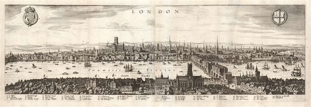
This is a Matthäus Merian view of London, engraved in 1638 for inclusion in his Archontologia cosmica. It was based on an earlier, 1616 panorama of the city by Claes Visscher (1587 - 1652.) The four-sheet, nearly seven-foot-long Visscher is an all but unobtainable rarity, with only a handful of known copies in institutional and private hands. (An example sold at Christies in 2018 for nearly $150,000.) The Merian expertly reduces the image, preserving much of its detail and elegance. The detail and recognizability of the image are particularly remarkable, given that neither Merian nor Visscher ever had visited London; Visscher's view was based on traditional printed maps (possibly including John Norden's Civitas Londini, which survives in a single copy in the Royal Library in Stockholm) and the reports of visitors at the turn of the century. Visscher's publisher, Jodocus Hondius, lived in London from 1587 to 1593, and he may have been consulted. Thus, despite being engraved during the reign of Charles I, the view is a depiction of Elizabethan London c. 1600; it remains one of the very few acquirable views of the city as it stood prior to the 1666 Great Fire of London.
The View
The panoramic view shows London from a fictional high point just south of the Thames. The old St. Paul's Cathedral and London Bridge dominate the central part of the view. To the right, the Tower of London can be seen with the tower's domes transformed into fanciful, almost slavic onion-style spires - but overall the view demonstrates impressively accurate representation of the city. The river is slightly straightened in the north part of the view, probably to aid in the presentation of detail beyond that bend.Key Features
While the Visscher was sufficiently large to label features on the view, Merian has instead compiled the labels in a list of 43 numerically keyed features. These are predominantly the steeples of the city's churches, but include palaces, important structures along the waterfront, and several of London's suburbs just visible in the distance. Among the mansions on the north bank of the river are Whitehall Palace (marked on the view, not the list), York House, Durham House, Burley House, and Arundel House. Old St Paul's Cathedral is shown without the spire (struck by lightning in 1561.) The Old London Bridge agrees with German visitor Paul Hentzner's report of the structure:...a bridge of stone eight hundred feet in length, of wonderful work; it is supported upon twenty piers of square stone, sixty feet high and thirty broad, joined by arches of about twenty feet diameter. The whole is covered on each side with houses so disposed as to have the appearance of a continued street, not at all of a bridge. Upon this is built a tower, on whose top the heads of such as have been executed for high treason are placed on iron spikes: we counted above thirty.The 'Traitors' Gate' is clearly depicted here, overlooking the busy traffic of the Southwarke Road (Now the A3). The detail of the south part of the city, showing what is now St. Katherine's Dock, shows that Merian's view was derived from the second state of Visscher's original: these details did not appear on the 1616 first state.
Shakespeare's London
On the south bank of the Thames appear four theater structures, three of which are labeled: The Swan, The Bear Garden, and The Globe - from 1599, the theatre of the 'King's Men,' Shakespeare's company.Publication History and Census
This view was created by Matthäus Merian for inclusion in his Archontologia cosmica, published in Frankfurt-am-Main, in 1638 with further editions noted in 1646 and 1649. The entire volume is well represented in institutional collections. The separate plate is catalogued only in the British Library, the Bayerische Staatsbibliothek, the Bibliotheque National de France, and the Folger Library.CartographerS
Matthäus Merian (September 22, 1593 - June 19, 1650), sometimes referred to as 'the Elder' to distinguish from his son, was an important Swiss engraver and cartographer active in the early to mid 17th century. Merian was born in Basel and studied engraving in the centers of Zurich, Strasbourg, Nancy and Paris. In time Merian was drawn to the publishing mecca of Frankfurt, where he met Johann Theodor de Bry, son of the famed publisher Theodor de Bry (1528 - 1598) . Merian and De Bry produced a number of important joint works and, in 1617, Merian married De Bry's daughter Maria Magdalena. In 1623 De Bry died and Merian inherited the family firm. Merian continued to publish under the De Bry's name until 1626. Around this time, Merian became a citizen of Frankfurt as such could legally work as an independent publisher. The De Bry name is therefore dropped from all of Merian's subsequent work. Of this corpus, which is substantial, Merian is best known for his finely engraved and highly detailed town plans and city views. Merian is considered one of the grand masters of the city view and a pioneer of the axonometric projection. Merian died in 1650 following several years of illness. He was succeeded in the publishing business by his two sons, Matthäus (1621 - 1687) and Caspar (1627 - 1686), who published his great works, the Topographia and Theatrum Europeaum, under the designation Merian Erben (Merian Heirs). Merian's daughter, Anna Maria Sibylla Merian, became an important naturalist and illustrator. Today the German Travel Magazine Merian is named after the famous engraver. More by this mapmaker...
Claes Jansz Visscher (1587 - 1652) established the Visscher family publishing firm, which were prominent Dutch map publishers for nearly a century. The Visscher cartographic story beings with Claes Jansz Visscher who established the firm in Amsterdam near the offices of Pieter van den Keer and Jadocus Hondius. Many hypothesize that Visscher may have been one of Hondius's pupils and, under examination, this seems logical. The first Visscher maps appear around 1620 and include numerous individual maps as well as an atlas compiled of maps by various cartographers including Visscher himself. Upon the death of Claes, the firm fell into the hands of his son Nicholas Visscher I (1618 - 1679), who in 1677 received a privilege to publish from the States of Holland and West Friesland. The firm would in turn be passed on to his son, Nicholas Visscher II (1649 - 1702). Visscher II applied for his own privilege, receiving it in 1682. Most of the maps bearing the Visscher imprint were produced by these two men. Many Visscher maps also bear the imprint Piscator (a Latinized version of Visscher) and often feature the image of an elderly fisherman - an allusion to the family name. Upon the death of Nicholas Visscher II, the business was carried on by the widowed Elizabeth Verseyl Visscher (16?? - 1726). After her death, the firm and all of its plates was liquidated to Peter Schenk. Learn More...
Source
Merian, M., Archontologia cosmica sive imperiorum (Frankfurt-am-Main), 1638.
Condition
Average. Mended tear from top to bottom with faint loss. Printed to two separate plates, joined at publication.
References
OCLC 556397410.