This item has been sold, but you can get on the Waitlist to be notified if another example becomes available, or purchase a digital scan.
1863 James Wyld Pocket Map of London, England
London-wyld-1863$500.00

Title
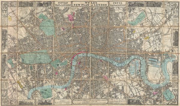
Wyld's New Plan of London.
1863 (dated) 22.5 x 38 in (57.15 x 96.52 cm)
1863 (dated) 22.5 x 38 in (57.15 x 96.52 cm)
Description
A large and appealing pocket map of London, england issued by James Wyld in 1863. Centered on the Thames, this map covers central London from Paddington Cemetery in the northwest to Hudson Town in the northeast, and from Parson's Green in the southwest to Greenwhich Park in the southeast. This map was issued in the same year that London's Underground, the world's first subway system, was opened. In addition to the original Hammersmith Line, this map also illustrates numerous other proposed metropolitan railroads – most of which had not been built as of the publication date. These include the Charing Cross Station, the liens to Broad Street and Cannon Street stations, and several others. Made with the foreign tourist in mind, Wyld's map shows most streets, important buildings, inns, churches, trading centers, markets, parks, and rail lines. The whole is surrounded by a decorative border bearing engraved views of famous London attractions, including, London Bridge, the Bank of england, The Crystal Palace, the Houses of Parliament, and many others. Secondary and tertiary titles in French and German appear to the right and left of the primary title, respectively. Wyld first issued this map in 1851 and it went through multiple states to reflect rapid urban development that transformed London into the first truly modern metropolis. This example is the 10th state, significant because of its treatment of the embryonic metropolitan transit system.
Cartographer
Wyld (1823 - 1893) was a British publishing firm active throughout the 19th century. It was operated by James Wyld I (1790 - 1836) and his son James Wyld II (November 20, 1812 - 1887) were the principles of an English mapmaking dynasty active in London during much of the 19th century. The elder Wyld was a map publisher under William Faden (1749 - 1836) and did considerable work on the Ordinance Survey. On Faden's retirement in 1823, Wyld took over Faden's workshop, acquiring many of his plates. Wyld's work can often be distinguished from his son's maps through his imprint, which he signed as 'Successor to Faden'. Following in his father's footsteps, the younger Wyld joined the Royal Geographical Society in 1830 at the tender age of 18. When his father died in 1836, James Wyld II was prepared to fully take over and expand his father's considerable cartographic enterprise. Like his father and Faden, Wyld II held the title of official Geographer to the Crown, in this case, Queen Victoria. In 1852, he moved operations from William Faden's old office at Charing Cross East (1837 - 1852) to a new, larger space at 475 Strand. Wyld II also chose to remove Faden's name from all of his updated map plates. Wyld II continued to update and republish both his father's work and the work of William Faden well into the late 1880s. One of Wyld's most eccentric and notable achievements is his 1851 construction of a globe 19 meters (60 feet) in diameter in the heart of Leicester Square, London. In the 1840s, Wyld also embarked upon a political career, being elected to parliament in 1847 and again in 1857. He died in 1887 following a prolific and distinguished career. After Wyld II's death, the family business was briefly taken over by James John Cooper Wyld (1844 - 1907), his son, who ran it from 1887 to 1893 before selling the business to Edward Stanford. All three Wylds are notable for producing, in addition to their atlas maps, short-run maps expounding upon important historical events - illustrating history as it was happening - among them are maps related to the California Gold Rush, the New South Wales Gold Rush, the Scramble for Africa, the Oregon Question, and more. More by this mapmaker...
Condition
Very good condition. Folds into original binder, which is attached to the upper left panel. Upper margin trimmed close by publisher at top, just right of center - please see image - can be extended for framing purposes. Dissected and mounted on linen.
References
Hyde, Ralph, Printed Maps of Victorian London, 1851 - 1900, no. 24-10.