This item has been sold, but you can get on the Waitlist to be notified if another example becomes available, or purchase a digital scan.
1875 Davies Pocket Map of London, England
LondonEnvirons-davies-1875$375.00

Title
Davies's New Map of the Environs of London.
1875 (dated) 30 x 43 in (76.2 x 109.22 cm)
1875 (dated) 30 x 43 in (76.2 x 109.22 cm)
Description
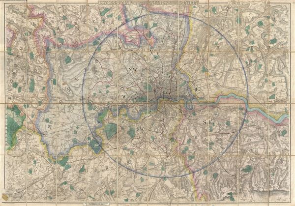
A beautifully engraved, impressively detailed, and colorful 1875 map of London by Benjamin Rees Davies. Centered on the Thames River valley, this map covers from Northaw to Grays Thurrock, and from Chipstead to Windsor. Names roads, farms, some buildings, and great estates throughout with color coding according to district. A colored circle defines a radius from Charing Cross of roughly 13 miles. Davis originally issued this map in 1855. It went through numerous editions and updates until about 1894, when it was finally discontinued. This is the 10th state dating to 1875.
Cartographer
Benjamin Rees Davies (1789 - December 16, 1872) was an engraver, cartographer, painter, and map publisher active in the early to mid-19th century. Davies was born in Holborn, England, apprenticed as under John Lodge in 1803. He began publishing around 1811 and is known to have compiled many of own maps from original survey work. From approximately 1848 onward Davies published in conjunction with the Stanford Firm. He is also known to have engraved a number of maps for the Dispatch Atlas and the S.D.U.K. Davies was an early adopter of steel plate engraving and used the exceptional hardness of steel to create some of the most delicately engraved and beautifully produced maps of his era. He was quite famous in England for his detailed street plans of London, which he began publishing in 1848. Davies is known to have worked with numerous other cartographers of his period including French, Mexican, and American map makers. Many of his maps and plans continued to be published and updated posthumously well into the 1880s. More by this mapmaker...
Condition
Very good condition. Dissected and mounted on linen. Attached in the upper left panel to original green linen binder.
References
Hyde, Ralph, Printed Maps of Victorian London, 1851 - 1900, #39-10.