
1851 Tallis Illustrated Pocket Map of London

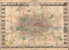

Tallis's Illustrated Plan of London and its Environs in commemoration of the Great Exhibition of Industry of all Nations, 1851.
Victorian London mapped as spectacle.
- Digital Map Information
- Suitable for large format printing
- Full resolution TIFF file
- ICC color profile embedded
- Delivered instantly via download link
Victorian London mapped as spectacle.
This is a superbly decorative 1851 John Tallis city plan of London, issued to commemorate the Great Exhibition and arguably Tallis's most ambitious single map. Touted on its release as 'the most beautiful and perfect Plan of London ever produced,' it makes a convincing case for the publisher's boast: John Rapkin's finely engraved plan is surrounded by an elaborate pictorial border of views depicting London's public buildings, monuments, and places of amusement. Both a practical city plan and lavish visual celebration of the Victorian metropolis, it captures London at a defining moment, when the Great Exhibition presented the city to the world as a center of industry, commerce, culture, and modernity.A Closer Look
Centered on the densely developed core of London and Westminster, the map extends west to Hammersmith, north to Cricklewood and Hampstead, east through Stamford Hill and Leytonstone, and south to Greenwich, Peckham, Battersea Rise, and Parsons Green. Streets, roads, city blocks, parks, important buildings, and places of interest are rendered in considerable detail, while borough divisions are distinguished through color. Relief in the less-developed outskirts is indicated by hachure. The result captures both the extraordinary density of central London and the still semi-rural character of many districts soon to be absorbed by the expanding metropolis.The plan itself is surrounded by 48 architectural and urban views, transforming what might otherwise have been a utilitarian street map into a visual portrait of the capital.
The combination is characteristic of Tallis and Rapkin. Rather than separating cartography from illustration, the design encourages the viewer to move continually between the abstract city seen from above and recognizable monuments encountered at street level. The map therefore serves simultaneously as a navigational aid, architectural panorama, and celebration of London.
A Metropolis in Transition
The plan's geographical extent makes it an especially evocative record of London in transition. The great urban core around the Thames is intensely developed, yet substantial portions of the surrounding territory remain open. Places that would later become thoroughly integrated into metropolitan London still appear at or beyond the edges of concentrated urban development.This juxtaposition gives the map significance beyond its connection with the Great Exhibition. London was undergoing explosive 19th-century growth, driven by industrialization, railway development, migration, and the expansion of commerce and empire. Tallis's map freezes that process at mid-century, showing the Victorian metropolis pushing outward but before later development had filled much of the territory between the older city and its surrounding communities.
The railway age is already reshaping this geography. By 1851, rail had fundamentally altered London's relationship with the rest of Britain, while new transportation networks accelerated suburban development and made the capital increasingly accessible to visitors. The Great Exhibition itself was inseparable from this new mobility, drawing enormous numbers of visitors into London and reinforcing the city's position as Britain's national and international center.
London and the Great Exhibition of 1851
The map's full title confirms that it was issued 'in commemoration of the great exhibition of industry of all nations, 1851.' The Great Exhibition provides the essential context for understanding both its extraordinary decoration and its intended audience. The exhibition site in Hyde Park is marked on the plan, situating Tallis's map within the exhibition's enormous publishing and souvenir industry.Opened in Hyde Park in 1851, the Great Exhibition presented manufactured goods, machinery, raw materials, decorative arts, and technological achievements from Britain and around the world. London was not merely the exhibition's location but part of the spectacle. Visitors encountered a city that stood at the center of an expanding global commercial and imperial system, and publishers eagerly produced guides, panoramas, maps, and souvenirs through which visitors could navigate and remember it.
Tallis's plan suited this audience particularly well. Its detailed street network made it useful to someone actually moving through London, while Lacey's multitude of architectural views turned the map into a keepsake. The elaborate presentation also reinforced the larger message surrounding the Great Exhibition: London was to be understood not simply as an old European capital, but as a modern global center of commerce, industry, architecture, and technological progress.
Publication History and Census
This map was published by John Tallis for release during the 1851 Industry of All Nations Exhibition. John Rapkin engraved it. The decorative surround is the work of H. Lacey. There appears to be only one edition, but in various formats, including dissected as here, and as foldouts in Tallis's Illustrated Atlas and Modern History of the World. Well represented institutionally but scarce on the private market.Cartographers
John Tallis (November 7, 1817 - June 3, 1876) was an English map publisher and bookseller. Born in Stourbridge, Worcestershire, he worked in his father's Birmingham agency from 1836 to 1842. Around 1838, Tallis published a collection of London Street Views and entered into a partnership with his brother Frederick Tallis from 1842 to 1849. Tallis and Company also published the Illustrated Atlas of the World (1849). Also in 1849, Tallis traveled to New York City, where he established agencies in 6 American cities. After returning from New York, Tallis paid his brother £10,000 for his share of the business and subsequently operated as John Tallis and Company until 1854. By 1853, John Tallis and Company had agencies in 26 cities in the United Kingdom, the United States, and Canada and employed over 500 people. On February 24, 1854, Tallis brought on a new partner, Ephraim Tipton Brain (1791 - 1876), forming the London Printing and Publishing Company. After a series of setbacks, however, Tallis had to sell his estate and by 1861 was declared bankrupt. Friends and former employees kept him afloat, but none of his 'various ambitious projects' proved lucrative. Tallis married Jane Ball on December 6, 1836, in Birmingham, and they lived together until she died in 1862. Tallis remarried on June 27, 1863, to Mary Stephens, with whom he had two children. Further Details...
John Rapkin (July 18, 1813 - June 20, 1899) was an English mapmaker and engraver. Born in Southwark, Rapkin was the son of George Rapkin, a shoemaker, and his wife Elizabeth Harfy. Rapkin and his brother Richard both became engravers and his other brother, William Harfy Rapkin, became a copperplate printer. Rapkin produced works for James Wyld and John Tallis, including The United States and the relative position of Oregon and Texas for Wyld around 1845, and a series of eighty maps for Tallis that became 'Tallis's illustrated atlas, and modern history of the world' in 1851. Rapkin married Frances Wilmot Rudell on January 4, 1837, with whom he had at least eight children, some of whom became engravers, including his sons John Benjamin Rapkin (1837 - 1914), Alfred Thomas Rapkin (1841 - 1905), Joseph Clarke Rapkin (1846? - 1912), and Frederick William Rapkin (1859 - 1945). Rapkin operated under the imprint 'John Rapkin and Sons from 1867 until 1883, and was operating as 'John Rapkin and Sons' by 1887. Rapkin died in 1899 at the age of 85 soon after the death of his wife of over sixty years. Further Details...
Condition
Very good. Original linen backing stable. Some yellow-ish discolorations along bottom. Accompanies original red gilt-stamped binder.
References
Rumsey 11711.002. OCLC 52516930.