This item has been sold, but you can get on the Waitlist to be notified if another example becomes available, or purchase a digital scan.
1884 Colton Wall Map of Long Island, New York
LongIsland-colton-1884$2,875.00

Title
Colton's New Map of Long Island.
1884 (dated) 31 x 64 in (78.74 x 162.56 cm) 1 : 126720
1884 (dated) 31 x 64 in (78.74 x 162.56 cm) 1 : 126720
Description
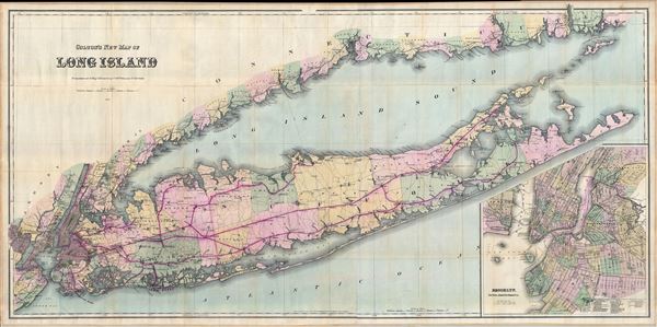
This is Colton's 1884 'New Map of Long Island,' possibly the largest and most dramatic map of Long Island to appear in the 19th century. Colton's map covers the region from Newark, Staten Island, and New York City eastward as far as Montauk and Fisher Island. Includes the entirety of Long Island, the Long Island Sound, Suffolk and Nassau counties, the Hamptons, and the Connecticut Coast. A large inset in the lower right quadrant details New York City, particularly lower Manhattan, Brooklyn, Long Island City, as well as parts of Queens and Jersey City.
Colton's first forays into the mapping of Long Island began in 1855 with his introduction of the 'Traveler's Map of Long Island,' a pocket format map designed for stage travelers and for commuters on the rapidly developing Long Island Railroad. The construction of the LIRR, in combination with the increasingly expensive and unsanitary conditions of Manhattan, spurred massive emigration to all parts of Long Island. Around 1873, recognizing the need for a large scale high quality map of Long Island, Colton redrew his rather small 'Traveler's Map' on a significantly larger and more dramatic scale, producing this, 'Colton's New Map of Long Island.' This map went through a series of editions in the subsequent years, reflecting an urgent need to keep up to date with Long Island's explosive growth. In this particular edition, 1884, the western part of the island is crisscrossed an advanced network of railways. The Brooklyn-Montauk railroad extend eastwards as far as Sag Harbor, and the main line itself extends as far as Greenport in the North Fork. The Hampton resort towns of Bridgehampton, Southampton, East Hampton, Amagansett, and Wainscott, all at this time sleepy fishing and farming communities, are well represented.
The earliest edition of this map was most likely 1873, though we know of no extant examples. The latest known edition was printed 1890 and additional known editions were published in 1888, 1884, and 1883. Copyrighted in 1873 by G.W. and C.B. Colton.
Cartographer
Joseph Hutchins Colton (July 5, 1800 - July 29, 1893), often publishing as J. H. Colton, was an important American map and atlas publisher active from 1833 to 1897. Colton's firm arose from humble beginnings when he moved to New York in 1831 and befriended the established engraver, Samuel Stiles. He worked under Stiles as the 'Co.' in Stiles and Co. from 1833 to 1836. Colton quickly recognized an emerging market in railroad maps and immigrant guides. Not a cartographer or engraver himself, Colton's initial business practice mostly involved purchasing the copyrights of other cartographers, most notably David H. Burr, and reissuing them with updated engraving and border work. His first maps, produced in 1833, were based on earlier Burr maps and depicted New York State and New York City. Between 1833 and 1855, Colton proceeded to publish a large corpus of guidebooks and railroad maps, which proved popular. In the early 1850s, Colton brought his two sons, George Woolworth Colton (1827 - 1901) and Charles B. Colton (1832 - 1916), into the map business. G. W. Colton, trained as a cartographer and engraver, was particularly inspired by the idea of creating a large and detailed world atlas to compete with established European firms for the U.S. market. In 1855, G.W. Colton issued volume one of the impressive two-volume Colton's Atlas of the World. Volume two followed a year later. Possibly because of the expense of purchasing a two-volume atlas set, the sales of the Atlas of the World did not meet Colton's expectations, and so, in 1856, the firm also issued the atlas as a single volume. The maps contained in this superb work were all original engravings, and most bear an 1855 copyright. All of the maps were surrounded by an attractive spiral motif border that would become a hallmark of Colton's atlas maps well into the 1880s. In 1857, the slightly smaller Colton's General Atlas replaced the Atlas of the World. Most early editions of the General Atlas published from 1857 to 1859 do not have the trademark Colton spiral border, which was removed to allow the maps to fit into a smaller format volume. Their customers must have missed the border because it was reinstated in 1860 and remained in all subsequent publications of the atlas. There were also darker times ahead; in 1858, Colton was commissioned at a sum of 25,000 USD by the government of Bolivia to produce and deliver 10,000 copies of a large format map of that country. Although Colton completed the contract in good faith, delivering the maps at his own expense, he was never paid by Bolivia, which was at the time in the midst of a series of national revolutions. Colton would spend the remainder of his days fighting with the Bolivian and Peruvian governments over this payment, and in the end, after a congressional intervention, he received as much as 100,000 USD in compensation. Nonetheless, at the time, it was a disastrous blow. J. H. Colton and Company is listed as one of New York's failed companies in the postal record of 1859. This led Colton into the arms of Alvin Jewett Johnson and Ross C. Browning. The 1859 edition of Colton's General Atlas lists Johnson and Browning as the 'Successor's to J. H. Colton' suggesting an outright buyout, but given that both companies continued to publish separately, the reality is likely more complex. Whatever the case may have been, this arrangement gave Johnson and Browning access to many of Colton's map plates and gave birth to Johnson's New Illustrated (Steel Plate) Family Atlas. The Johnson's Atlas was published parallel to Colton's atlases well into the 1880s. The Colton firm itself subsequently published several other atlases including an Atlas of America, the Illustrated Cabinet Atlas, the Octavo Atlas of the Union, and Colton's Quarto Atlas of the World. They also published a large corpus of wall maps, pocket maps, and guides. The last known publications of the Colton firm date to 1897 and include a map and a view, both issued in association with the Merchant's Association of New York. Alice M. Colton married August R. Ohman (May 3, 1859 - April 22, 1934) on January 5, 1897. In 1898, Ohman joined the Colton firm, which continued to publish as Colton, Ohman & Co. until 1901. More by this mapmaker...
Condition
Very good condition. Professionally flattened and backed on fine linen. Original linen binder included.
References
Rumsey 0167.000. Not in Phillips or Haskell.