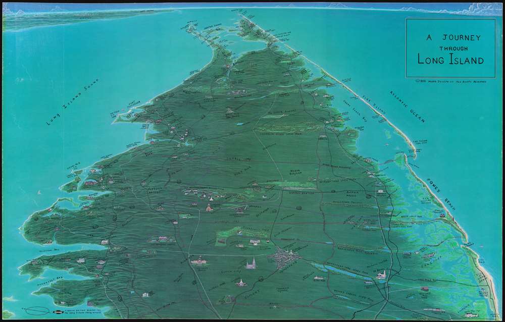
1980 Joseph Bird's-Eye View or Map of Eastern Long Island
LongIsland-joseph-1980$950.00

Title
A Journey through Long Island.
1980 (dated) 22.5 x 35.75 in (57.15 x 90.805 cm)
1980 (dated) 22.5 x 35.75 in (57.15 x 90.805 cm)
Description
This is a dramatic previously uncataloged 1980 Mark-Joseph Company bird's-eye view map of eastern Long Island, including all of Suffolk County. Overlooking Long Island from high above Queens County, likely sites one would visit while on a 'journey through Long Island' appear. The Long Island Railroad snakes its way east, all the way to Montauk and Orient Park. Printed as a special edition for Long Island Chevrolet dealers, of which there are half a dozen today, the region's road network is emphasized, likely to show just how easy it was to explore the area. One wonders if there were more dealers in the area in 1980. Major roads, including State Route 25A, 25, 454, 27, and 27A, are all labeled, allowing day trippers an overview of how best to reach their desired destination. Both MacArthur Airport and Republic Airport are illustrated, as are the Theodore Roosevelt Burial Ground, the Belmont Race Track, numerous museums, the Montauk and Orient Lighthouses, and Shelter Island. County lines appear in dark gray, making them more difficult to discern than the roads or the LIRR. Jones Beach and Fire Island are both illustrated.
Publication History and Census
This map was created by the Mark-Joseph Company and published in 1980 as a special edition for Long Island Chevrolet dealers. This is the only known example.Condition
Very good. Blank on verso.