This item has been sold, but you can get on the Waitlist to be notified if another example becomes available, or purchase a digital scan.
1911 Long Island Railroad Map of Long Island
LongIsland3-longislandrailroad-1911$150.00

Title
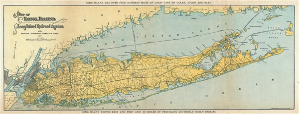
Map of Long Island showing the Long Island Railroad System and Montauk Steamboat Company Lines.
1911 (dated) 8.5 x 21.5 in (21.59 x 54.61 cm) 1 : 390000
1911 (dated) 8.5 x 21.5 in (21.59 x 54.61 cm) 1 : 390000
Description
This appealing promotional map of Long Island was issued in 1911 by the Long Island Railroad. It depicts Long Island in full, inclusive of Manhattan, Brooklyn, Queens, the Long Island Sound, and the southern shore of Connecticut and northern parts of Staten Island as well as parts of eastern New Jersey. The map shows the progress of the Long Island Railroad system as well as the Montauk Steamboat Company lines. It also notes important towns, bays, roads, harbors, beaches and other topographical details. The top and bottom margins contains the lines 'Long Island has over four hundred miles of coast line on ocean, sound and bays,' and 'Long Island trends east and west and is cooled by prevailing southerly ocean breezes.' This map was issued by the Long Island Railroad Company and engraved by the American Bank Note Company in 1911.
Condition
Very good. Minor wear along original fold lines. Minor edge wear. Backed with archival tissue.
References
OCLC: 695538241.