This item has been sold, but you can get on the Waitlist to be notified if another example becomes available, or purchase a digital scan.
1842 Mather Map of Long Island, New York
LongIsland5-mather-1842$1,500.00

Title
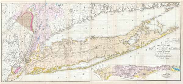
Geological Map of Long & Staten Islands with the Environs of New York.
1842 (dated) 23 x 52 in (58.42 x 132.08 cm) 1 : 165000
1842 (dated) 23 x 52 in (58.42 x 132.08 cm) 1 : 165000
Description
Issued prior to the American Civil War and the subsequent Long Island land rush, this is one of the most detailed and attractive large format maps of Long Island to appear in the 19th Century. It is also the first comprehensivle geological study of Long Island. The map covers from New Jersey and Staten Island eastward as Montauk and Fisher's Island. Includes parts of Westchester, New Jersey, Rockland County, and the Connecticut coastline. A large inset map in the lower right hand quadrant depicts Manhattan with a special focus on geological features and topography. Shows the partially completed Long Island Railroad as well as smaller roads and towns. Notes various important Long Island communities including the East Hampton, Bridgehampton, Southampton, Amaganset, Riverhead, and Sag Harbor, among others. In many cases individual buildings are detailed. The whole is laid out on a grid structure of ten mile squares. Prepared by W.W. Mather from the survey work of John Calvin Smith. Engraved by Endicott & Company for part one of Mather's Geology of New York.
CartographerS
William W. Mather (May 24, 1804 - February 26, 1859) was an important American geologist and natural historian. Mather was born in Brooklyn, Connecticut to an old New England family. In 1823, as a young man, he entered the West Point military academy after which he served as a 2nd Lieutenant in the Seventh Infantry. His interest in Chemistry and mineralogy soon called him back to West Point where he acted as an Assistant Professor of Geology. After resigning from the Army in 1834 with a rank of 1st Lieutenant, Mather accepted a position as Professor of Chemistry at the University of Louisiana. Later he was employed as Professor of Natural History and Sciences at the University of Ohio, was appointed Geologist of the First Geological District of New York for Governor William H. Seward, and was the State Geologist of both Ohio and Kentucky. In 1847 Mather became president of the University of Ohio. During his long career Mather made copious notes regarding his geological explorations, published profusely, and had a lively and extensive correspondence - much of which remains accessible to this day. Mather reports on one humorous incident in Long Island where, while collecting rock specimens, he had a run-in with a local farmer. The famer, observing the care with which Mather collected and cataloged his rock specimens, assumed that Mather had, in fact, discovered gold! Mather died in Columbus, Ohio on February 26, 1859. Today the W.W. Mather Medal is an important Geologic Reserach commendation. (Collections of the Minnesota Historical Society, p. 133.) More by this mapmaker...
John Calvin Smith (1809 – June 11, 1890) was an American surveyor and geographer active in New York during the middle part of the 19th century. He was a charter member of the American Geographical and Statistical Society (American Geographical Society). He worked with other important New York cartographers including John Disturnell, George Sherman, and Samuel Stiles, with whom he often published under the Stiles, Sherman & Smith imprint. Stiles may have introduced Smith to J. H. Colton, who acquired many of his map plates in 1853. Most of Smith's maps focus on New York counties, but he also issued maps of the United States, Illinois, Texas, and the California gold fields. Despite being an important and prolific cartographer, much of his personal life and history are shrouded in mystery. Learn More...
Endicott and Company (fl. c. 1828 - 1891) was a New York based family run lithography firm that flourished throughout the 19th century. The firm was founded by George and William Endicott, brothers who were born in Canton, Massachusetts. George Endicott (June 14, 1802 - 1848) trained as a lithographer under Pendleton Lithography from January 1826. He later worked as superintendent of Senefelder Company until the summer of 1828. Afterwards, in 1830, he relocated to Baltimore and partnered with Moses Swett. Endicott and Swett relocated to New York City in December 1831. They remained partners until July 1834 when the relationship dissolved. George set up shop on his own account at 359 Broadway. William Endicott (1815 - 1851), George's younger brother of 14 years, joined the firm in 1840 and was made a partner in 1845, after which the name of the firm was changed to G. and W. Endicott. George Endicott died shortly afterward, in 1848, but William continued operating the firm as William Endicott and Co. until his own 1851 death at just 35 years old. The firm was carried on by his widow Sara Munroe Endicott until it was taken over by her son, Francis Endicott, who ran the firm from 1852 to 1886. George Endicott, Jr. subsequently ran the firm from 1887 to 1891. Peters, in his important work on American lithography America on Stone writes 'it is hard to summarize the Endicotts. They did everything and did it well . . . [they] worked with and for Currier and Ives, yet in spite of all that much of their work lacks real individuality.' The Endicott firm was responsible for many 19th century views and plans of New York City and state as well as plans of Sacramento, California, and the Midwest. Learn More...
Source
Mather, W. W., Geology of New York, Part 1, 1842.
Condition
Very good condition. Due to this map's unusual fold metric, all examples exhibit acid tonig to some of the fold sections on the right side, but this specific example has the least such we have yet seen. A few minor repaired tears.
References
New York Public Library, Map Division, 01-5149. Haskell, D., Manhattan Maps: A Co-operative List, 865. OCLC 23046374.