
Smith, John Calvin

John Calvin Smith (1809 – June 11, 1890) was an American surveyor and geographer active in New York during the middle part of the 19th century. He was a charter member of the American Geographical and Statistical Society (American Geographical Society). He worked with other important New York cartographers including John Disturnell (1801 - 1877), George E. Sherman (1812 - 1858), and Samuel Stiles (1796 - 1861), with whom he often published under the Stiles, Sherman & Smith imprint. Stiles may have introduced Smith to J. H. Colton (1800 - 1893), who acquired many of his map plates in 1853. Most of Smith's maps focus on New York counties, but he also issued maps of the United States, Illinois, Texas, and the California gold fields. Despite being an important and prolific cartographer, much of his personal life and history are shrouded in mystery.
Detailing the transportation network of the Upper Midwest.
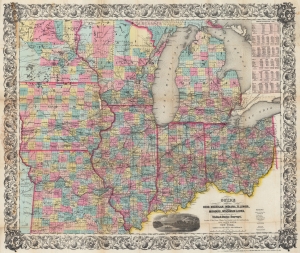
Guide Through Ohio, Michigan, Indiana, Illinois, Missouri, Wisconsin, and Iowa. Showing the Township lines of the United States Surveys, Locations of Cities, Towns, Villages, Post Hamlets, Canals, Rail and Stage Roads.
$1,200.00
Acquire
- Digital Map Information
- Suitable for large format printing
- File Size: 46.6 MB
- File Type: ZIP / TIFF
- ICC color profile embedded
- Delivered instantly via download link
This is an 1855 John Calvin Smith and John H. Colton map of Ohio, Michigan, Indiana, Illinois, Missouri, Wisconsin, and Iowa, along with part of Minnesota. The map captures a pivotal moment as mass emigration, developing industries, and displaced indigenous people transformed regional social, economic, and political spheres. (more details)
Best early map of Long Island.
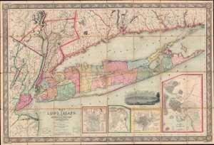
Map of Long Island, with the Environs of New-York and the Southern Part of Connecticut, compiled from Various Surveys and Documents.
$6,750.00
Acquire
- Digital Map Information
- Suitable for large format printing
- File Size: 203.5 MB
- File Type: ZIP / TIFF
- ICC color profile embedded
- Delivered instantly via download link
A fine example of John Calvin Smith and J. H. Colton's 1856 map of Long Island. This is the largest, most significant, and most beautiful map of Long Island to be issued in the 19th century. It is also very likely the first map published by American cartographic titan, J. H. Colton. (more details)
One of the largest and most beautiful American commercial maps published in the 19th century.
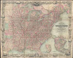
Map of the United States of America Including Canada, and a large portion of Texas, Showing Base Meridian and Township Lines of the U.S. Surveys, Including Lands alotted to the Indian Tribes west of the Mississippi, The various internal improvements.
$7,500.00
Acquire
- Digital Map Information
- Suitable for large format printing
- Full resolution TIFF file
- ICC color profile embedded
- Delivered instantly via download link
One of the most striking American large format wall maps ever issued. This is the 1862 American Civil War era case map of the United States by J. Calvin Smith and updated by J. H. Colton. The map covers from Austin Texas to the eastern seaboard and from Lake Superior to the Gulf of Mexico. Smith first introduced this map in 1843 buy the present much revised and updated example is the 1862 Civil War Colton edition. When it was introduced in 1843, this map was hailed as the largest, best, and most detailed map of the United States yet published. (more details)
A landmark map of Long Island and the earliest Long Island Wall Map.

Geological Map of Long & Staten Islands with the Environs of New York.
sold
- Digital Map Information
- Suitable for large format printing
- Full resolution TIFF file
- ICC color profile embedded
- Delivered instantly via download link
First geological map of Long Island.

Geological Map of Long and Staten Islands with the Environs of New York.
sold
- Digital Map Information
- Suitable for large format printing
- Full resolution TIFF file
- ICC color profile embedded
- Delivered instantly via download link