This item has been sold, but you can get on the Waitlist to be notified if another example becomes available, or purchase a digital scan.
1895 Eldridge Nuatical Chart or Map of the Long Island Sound, New York
LongIslandSound-eldridge-1895$2,000.00

Title
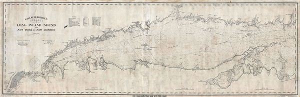
Geo. W. Eldridge's Chart C Long Island Sound from New York to New London.
1895 (dated) 27.5 x 85 in (69.85 x 215.9 cm)
1895 (dated) 27.5 x 85 in (69.85 x 215.9 cm)
Description
A fine example of George W. eldridge's scarce nautical chart or map of the Long Island Sound. eldridge's monumentally proportioned chart covers the Long Island Sound from New York City to New London, Connecticut, Race Rock, and Gardiner's Island. It includes the northern Coast of Long Island, including Shelter Island, Gardiner's Island, and Plum Island, and the southern coast of Connecticut. Though primarily a nautical chart with little inland detail, eldridge does map major harbors along both coastlines. eldridge further offers a wealth of maritime detail including countless depth soundings, shading to indicate coastal shoals, multiple compasses, identification of various buoys and lighthouses, and mileage. There are a few pencil marks and other notations dating to this map's early days as a working sea chart. Though published in some quantity, this maritime map has become very scarce due the simple fact that the conditions of use have destroyed most examples.
Cartographer
George Eldridge (November 27, 1821 - August 23, 1900) and his son George Washington Eldridge (1845 - 1914) were American makers of nautical charts and Pilot Books active in the late 19th century. George Eldridge was a Cape Cod fisherman known locally as an excellent ship's pilot. While recuperating from an injury in 1851, Eldridge drew his first nautical chart. The chart proved popular, and its success led Eldridge to pursue a career in hydrography - the science of mapping the sea with a special focus on navigation. Eldridge produced numerous subsequent maps and is credited with issuing some of the earliest accurate nautical charts of the American Atlantic coast. In time George Eldridge passed his thriving business on to his son, George Washington Eldridge, who continued to produce beautiful and practical maritime charts until 1924.Though most of Eldridge's charts were loosely based on U.S. Coast Survey work, they proved popular with navigators. The Eldridges possessed a talent, shared by both father and son, for distilling the often convoluted Coast Survey maps into practical nautical charts for the working mariner. From 1875, in addition to large format independently issued nautical charts, Eldridge also issued annual editions of Eldridge's Tide and Pilot Book and The Book of Harbor Charts. The Eldridge offices were located at 103 State St. Boston, Massachusetts. After the deaths of George and George Washington Eldridge, the firm passed into the hands of the latter's widow Sydna, and son-in-law, Wilfrid O. Wight. Wight's son and subsequent generations have continued to publish the Eldridge Tide and Pilot Book down to the present. More by this mapmaker...
Condition
Good Condition. Has been used in for actual navigation. Chart exhibits some wear and has been professionally flattened, restored, and backed on fine linen.