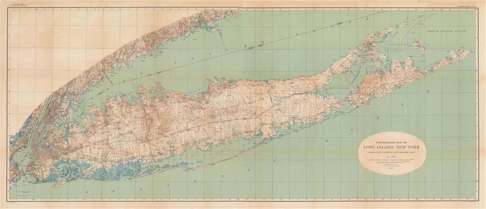
1913 U.S. Geological Survey Topographic Map of Long Island
LongIslandTopographic-geologicalsurvey-1913$1,000.00

Title
Topographic Map of Long Island, New York.
1913 (dated) 27.25 x 63.5 in (69.215 x 161.29 cm) 1 : 125000
1913 (dated) 27.25 x 63.5 in (69.215 x 161.29 cm) 1 : 125000
Description
This is a large format 1913 U.S. Geological Survey topographic map of Long Island. Aside from topography, the map provides a clear sense of the growing population and infrastructure of the island when the map was made.
Until the early 20th century, Long Island was sparsely populated farming country, but the growing population of New York City and the ease of travel to the city using railroads or automobiles led to a population boom. Notably, wealthy urbanites built luxurious country estates on the north shore of Long Island, memorably documented in F. Scott Fitzgerald's The Great Gatsby. On the southern shore of the island, just into the Borough of Queens, a more plebian class of New Yorkers relaxed at the amusement parks and entertainment venues on Rockaway Beach.
The several lines of the Long Island Railroad formed the backbone of transportation infrastructure between the city and Long Island. The first express roadways for automobiles on Long Island opened in the years just before this map's publication, most notably the Vanderbilt Parkway, privately built by William Kissam Vanderbilt II in 1908 for racing purposes.
By the 1920s and 1930s, a growing bureaucracy was required at the local, county (Nassau and Suffolk), and state level to manage the rapidly changing landscape of Long Island. Among those involved with these efforts was Robert Moses, who began his career as President of the Long Island State Park Commission. Among his greatest impacts on Long Island was the prioritization of automobile parkways, making the suburban sprawl of the mid-20th century possible.
A Closer Look
Coverage extends from the shores of New Jersey and Connecticut in the west to Montauk in the east, taking in New York City, including the western portion of Long Island that became the Boroughs of Queens and Brooklyn at the end of the 19th century. The distinctive topography of the island is immediately apparent, with marshy lowlands on the south side and relatively higher elevations on the north side facing Long Island Sound.Until the early 20th century, Long Island was sparsely populated farming country, but the growing population of New York City and the ease of travel to the city using railroads or automobiles led to a population boom. Notably, wealthy urbanites built luxurious country estates on the north shore of Long Island, memorably documented in F. Scott Fitzgerald's The Great Gatsby. On the southern shore of the island, just into the Borough of Queens, a more plebian class of New Yorkers relaxed at the amusement parks and entertainment venues on Rockaway Beach.
The several lines of the Long Island Railroad formed the backbone of transportation infrastructure between the city and Long Island. The first express roadways for automobiles on Long Island opened in the years just before this map's publication, most notably the Vanderbilt Parkway, privately built by William Kissam Vanderbilt II in 1908 for racing purposes.
By the 1920s and 1930s, a growing bureaucracy was required at the local, county (Nassau and Suffolk), and state level to manage the rapidly changing landscape of Long Island. Among those involved with these efforts was Robert Moses, who began his career as President of the Long Island State Park Commission. Among his greatest impacts on Long Island was the prioritization of automobile parkways, making the suburban sprawl of the mid-20th century possible.
Publication History and Census
This map was prepared by the U.S. Geological Survey and published by Julius Bien, a well-known government and commercial printer based in New York City. In 1914, the geologist Myron L. Fuller and the Geological Survey published a book titled The Geology of Long Island, New York (OCLC 699742538), which is the 'Professional Paper no. 82' referred to at top-right. Both the map, when cataloged independently, and the book are held by a small handful of libraries in North America and Europe.CartographerS
The United States Geological Survey (1878 - Present), aka the U.S.G.S., is a scientific agency of the United States government, which was founded in 1879. USGS scientists study the landscape of the United States, its natural resources, and the natural hazards that threaten it. The organization has four major science disciplines: biology, geography, geology, and hydrology. It is a bureau of the United States Department of the Interior and is the department's only scientific agency. More by this mapmaker...
Julius (Julien) Bien (September 27, 1826 - December 21, 1909) was a German-Jewish lithographer and engraver based in New York City. Bien was born in Naumburg, Germany. He was educated at the Academy of Fine Arts, Cassell and at Städel's Institute, Frankfurt-am-Main. Following the suppression of the anti-autocratic German Revolutions of 1848, Bien, who participated in the pan-German movement, found himself out of favor in his home country and joined the mass German immigration to the United States. Bien can be found in New York as early as 1849. He established the New York Lithographing, Engraving & Printing Company in New York that focused on the emergent chromo-lithograph process - a method of printing color using lithographic plates. His work drew the attention of the U.S. Government Printing Office which contracted him to produce countless government maps and surveys, including the Pacific Railroad Surveys, the census, numerous coast surveys, and various maps relating to the American Civil War. Bien also issued several atlases both privately and in conjunction with a relation, Joseph Bien. At the height of his career Bien was elected president of the American Lithographers Association. After his death in 1909, Bien's firm was taken over by his son who promptly ran it into insolvency. The firm was sold to Sheldon Franklin, who, as part of the deal, retained the right to publish under the Julius Bien imprint. In addition to his work as a printer, Bien was active in the New York German Jewish community. He was director of the New York Hebrew Technical Institute, the New York Hebrew Orphan Asylum, and president of the B'nai B'rith Order. Learn More...
Source
Myron L Fuller, Geological Survey (U.S.), The geology of Long Island, New York, U.S. Geological Survey Professional Paper 82 (1913).
Condition
Very good. Some discoloration along fold lines and in margins.
References
Rumsey 4230.000. OCLC 25622297.