This item has been sold, but you can get on the Waitlist to be notified if another example becomes available, or purchase a digital scan.
1910 Pennsylvania Railroad Promotional Wall Map of the United States
LookAtTheMap-pennrailroad-1910$850.00

Title
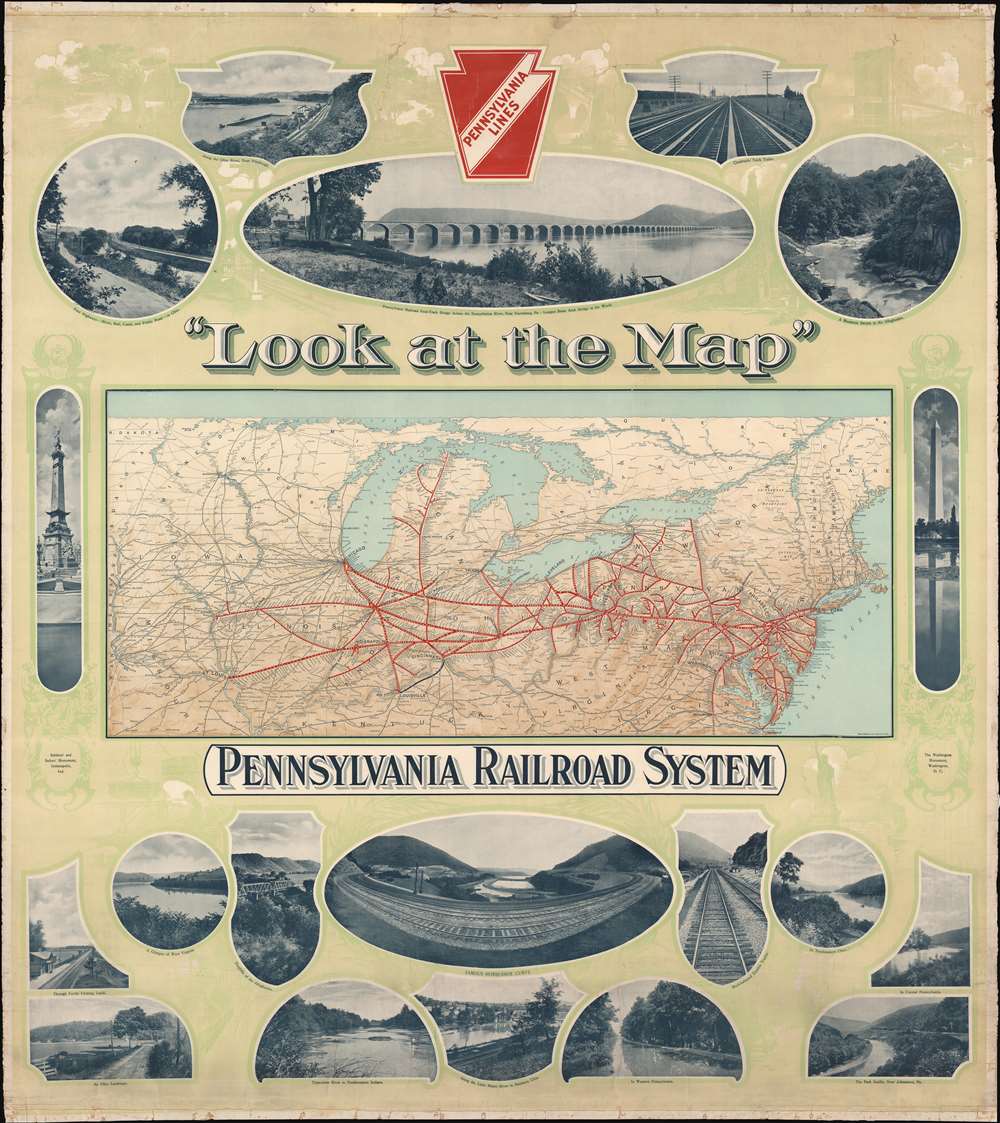
'Look at the Map'. Pennsylvania Railroad System.
1910 (undated) 51 x 45.25 in (129.54 x 114.935 cm) 1 : 2225000
1910 (undated) 51 x 45.25 in (129.54 x 114.935 cm) 1 : 2225000
Description
This c. 1910 Pennsylvania Railroad wall map of the United States promotes the natural beauty of the United States, and the ease of access to that beauty granted by the Pennsylvania Railroad. A map of the Pennsylvania's rail network occupies the center and thick red lines highlight its routes. White dots mark most of the stations and thin black lines mark major connecting railroads. Printed photographs surround the map and provide views of the vistas offered to the Pennsylvania's passengers, including mountain streams, major rivers, wooded hillsides, and open farmland. Other photos highlight the Pennsylvania's iconic infrastructure, such as the 'famous horseshoe curve' or the Pennsylvania Railroad four-track bridge across the Susquehanna River at New Harrisburg, Pennsylvania. Photos of the Washington Monument in Washington, D.C. and the Soldiers' and Sailors' Monument in Indianapolis flank the central map. Faint green illustrations fill the rest of the background and depict landmarks such as the Statue of Liberty and the Brooklyn Bridge alongside vignettes of workers in factories and idyllic countryside scenes.
Publication History and Census
This map was created by Rand McNally and Company and published by the Pennsylvania Railroad c. 1910. We see no examples catalogued in OCLC, in dealers' catalogues or in auction records; we have identified no other surviving examples of this map.Cartographer
Rand, McNally and Co. (fl. 1856 - present) is an American publisher of maps, atlases and globes. The company was founded in 1856 when William H. Rand, a native of Quincy, Massachusetts, opened a print shop in Chicago. Rand hired the recent Irish immigrant Andrew McNally to assist in the shop giving him a wage of 9 USD per week. The duo landed several important contracts, including the Tribune's (later renamed the Chicago Tribune) printing operation. In 1872, Rand McNally produced its first map, a railroad guide, using a new cost effective printing technique known as wax process engraving. As Chicago developed as a railway hub, the Rand firm, now incorporated as Rand McNally, began producing a wide array of railroad maps and guides. Over time, the firm expanded into atlases, globes, educational material, and general literature. By embracing the wax engraving process, Rand McNally was able to dominate the map and atlas market, pushing more traditional American lithographic publishers like Colton, Johnson, and Mitchell out of business. Eventually Rand McNally opened an annex office in New York City headed by Caleb S. Hammond, whose name is today synonymous with maps and atlases, and who later started his own map company, C. S. Hammond & Co. Both firms remain in business. More by this mapmaker...
Condition
Good. Backed on old linen. Linen hinging tape added to verso to reinforce the map. large stabilized tear from upper margin, extending approximately 5 inches into printed area. Edges exhibit wear.
References
Not in OCLC.