This item has been sold, but you can get on the Waitlist to be notified if another example becomes available, or purchase a digital scan.
1865 Blunt Nautical Chart or Map of the Southeastern United States Coast
LookoutCanaveral-blunt-1865$500.00

Title
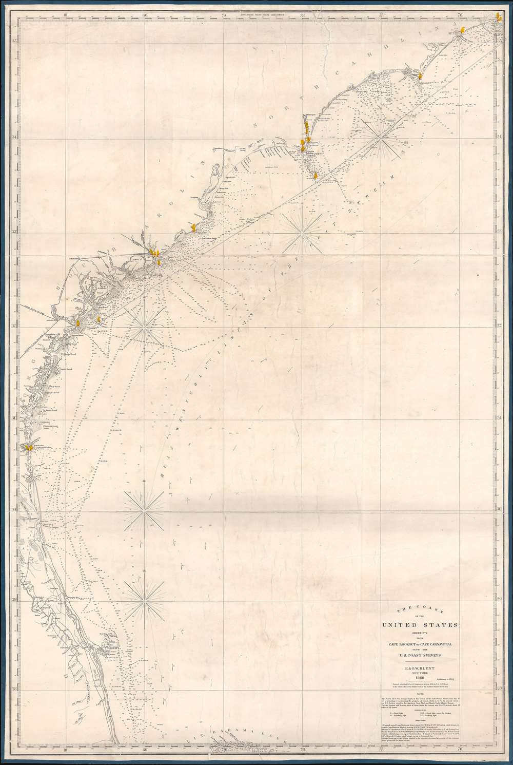
The Coast of the United States Sheet No. 2 from Cape Lookout to Cape Carnaveral from the U.S. Coast Survey.
1865 (dated) 47.75 x 32 in (121.285 x 81.28 cm) 1 : 735000
1865 (dated) 47.75 x 32 in (121.285 x 81.28 cm) 1 : 735000
Description
This is a rare 1865 Civil War Era Edmund and George William Blunt 'blockade runner' nautical map of the southeastern coast of the United States extending roughly from Cape Hatteras, North Carolina, to Cape Canaveral (written Carnaveral here), Florida. Benefiting from the work of the U.S. Coast Survey, the chart boasts impressive coastal detail, illustrating innumerable coastal islands, inlets, points, and other important navigational hazards. Depth soundings appear along the coast. Railroads are illustrated operating out of Savannah and Charleston, emphasizing their economic importance to the Confederate States of America.
A Blockade Runner's Chart?
The coverage, detail, and publication run, 1860 - 1865, of the map beg the question of why it was made at all? The Blunt firm was a private publisher based out of New York, so their maps would not have been in demand by the U.S. Navy, which had access to superior U.S. Coast Survey charts. Nor was there significant 'legitimate' private trade, as southern ports were blockaded. The detail present along the southern coastline, along with the indication of the critical railroad lines, is telling. This chart can only have been intended for Blockade Runners and smuggling goods out of southern ports to Europe, which was heavily dependent upon southern cotton. Typically, goods, mostly cotton, would be shipped clandestinely to the Bahamas, where they were unloaded by merchant companies and transferred to neutral vessels bound for London or France. While the Blunt firm operated in the heart of the Union, and there is no evidence they had Confederate sympathies, they may well have recognized a business opportunity. Perhaps they were able to sell such charts to European navigators calling in New York, who would then use them themselves, or sell the charts on to compatriots. This hypothesis, however, does run counter to the fact that the Edmund Blunt and his sons had a close relationship to the U.S. Coast Survey, which makes the private publication of a chart based on the Coast Survey's work of the Confederacy during Civil War very intriguing.Blueback Charts
Blueback nautical charts began appearing in London in the late 18th century. Bluebacks, as they came to be called, were privately published large format nautical charts known for their distinctive blue paper backing. The backing, a commonly available blue manila paper traditionally used by publishers to wrap unbound pamphlets, was adopted as a practical way to reinforce the low-quality paper used by private chart publishers to cut costs. That being said, not all blueback charts are literally backed with blue paper. The earliest known blueback charts include a 1760 chart issued by Mount and Page, and a 1787 chart issued by Robert Sayer. The tradition took off in the early 19th century, when British publishers like John Hamilton Moore, Robert Blachford, James Imray, William Heather, John William Norie, Charles Wilson, David Steel, R. H. Laurie, and John Hobbs, among others, rose to dominate the chart trade. Bluebacks became so popular that the convention was embraced by chartmakers outside of England, including Americans Edmund March Blunt, Charles Copley, and George Eldridge, as well as Scandinavian, French, German, Russian, and Spanish chartmakers. Blueback charts remained popular until the late 19th century, when government-subsidized organizations like the British Admiralty Hydrographic Office and the United States Coast Survey, began issuing their own superior charts on high-quality paper that did not require reinforcement.Publication History and Census
This map drawn by Edmund and George William Blunt and first issued in 1858, when it was copyrighted by the brothers, suggesting that they had already taken over most of the day-to-day activities of their father's firm. A second edition was published in 1860, shortly before the American Civil War (1861 - 1865). A third edition appeared with updated information in 1861, along with a fourth edition in 1864, with only one known cataloged example in private hands. A fifth edition, as here, was issued with updates in 1865. Two examples of the present 5th edition are known, at the Library of Congress and the University of North Carolina at Chapel Hill. While we have not been able to locate an 1862 or 1863 edition, given the presence of the 1860, 1861, 1864, and 1865 editions, we suspect that updated charts dating from those years likely exist as well.Cartographer
Edmund March Blunt (June 20, 1770 - 1862) was an American navigator, bookseller, chartmaker, and cartographer based in Newburyport, Massachusetts. Blunt was born in Portsmouth, New Hampshire in 1770. In 1796, along with the nominal assistance of prominent navigator Captain Lawrence Furlong, Blunt published The American Coast Pilot, one of the most important published works on American navigation. Although much of the work was plagiarized from British publications, the Coast Pilot was an immediate popular success. In response to the popularity of his work, Blunt published 21 subsequent editions, each with important updates and revisions. The first edition to contain map plates was printed in 1804. Following a fire that destroyed his offices at The Sign of the Bible in 1811, Blunt moved his business to New York and opened a new shop, The Sign of the Quadrant. His sons Edmund Jr. (1799 - 1866) and George William (1802 - 1878), joined the firm in 1824 and eventually took over the family business, renaming the firm 'E. and G. W. Blunt'. They both produced their own nautical books, charts, and instruments, as well as republished their father’s work. In 1830, Edmund accepted a position under Ferdinand Hassler at the United States Office of the Coast Survey. Much of Blunt's original work eventually found its way into U.S. Coast Survey Publications. George closed the firm in 1872 and sold the plates and chart copyrights to the U.S. Coast Survey and the U.S. Navy Hydrographic Office. Due to the quality and detail of Blunt's work, revised editions of his most important charts were republished well into the 1880s. More by this mapmaker...
Condition
Very good. Full professional restoration. Closed tears evident.
References
OCLC 72068860.