This item has been sold, but you can get on the Waitlist to be notified if another example becomes available, or purchase a digital scan.
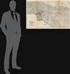
1925 Auto Club of Southern California Map of Los Angeles and Environs
LosAngeles-autoclubsocal-1925$100.00

Title
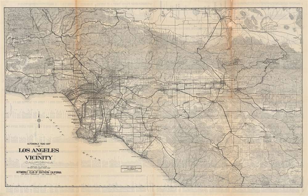
Automobile road map of Los Angeles and vicinity, California.
1925 (undated) 27.75 x 43.5 in (70.485 x 110.49 cm) 1 : 200000
1925 (undated) 27.75 x 43.5 in (70.485 x 110.49 cm) 1 : 200000
Description
This is an impressive c. 1925 map of the Los Angeles area published by the Automobile Club of Southern California. Presaging the city's later sprawl, the map covers most of the present-day metropolitan region, including all or parts of Los Angeles, Ventura, San Bernardino, Riverside, and Orange Counties.
The Automobile Club of Southern California could be considered part of a late group of L.A. 'boosters' who sought to brandish an image of Southern California as a comfortable paradise fit for relocation from the east coast and Midwest. This vision could conflict with more established residents who wanted to maintain the rustic feel and relatively small population of the region. One prominent example involved what became Malibu, which had been owned by the extremely wealthy local magnate Frederick H. Rindge and his wife Rhoda May Knight Rindge, who fiercely resisted repeated attempts to develop the area. The Rindges even went so far as to build their own railroad and real estate projects to block larger outfits like the Southern Pacific Railway from claiming eminent domain over their lands.
Eventually, the county and state government forced the issue, building a coastal road through the Rindges' ranch in the early 1920s, later upgraded to the Theodore Roosevelt Highway (now the Pacific Coast Highway) and a road (now Kanan Dume Rd./ County Route N9) connecting the coastal road to the State Highway (now U.S.-101). The Rindges won some vindication in the end, as the Southern Pacific never went through Malibu and its successor routes still take an odd inland turn at Oxnard to avoid the area, while Malibu residents have maintained their intense opposition to development that threatens their coastal paradise.
A Closer Look
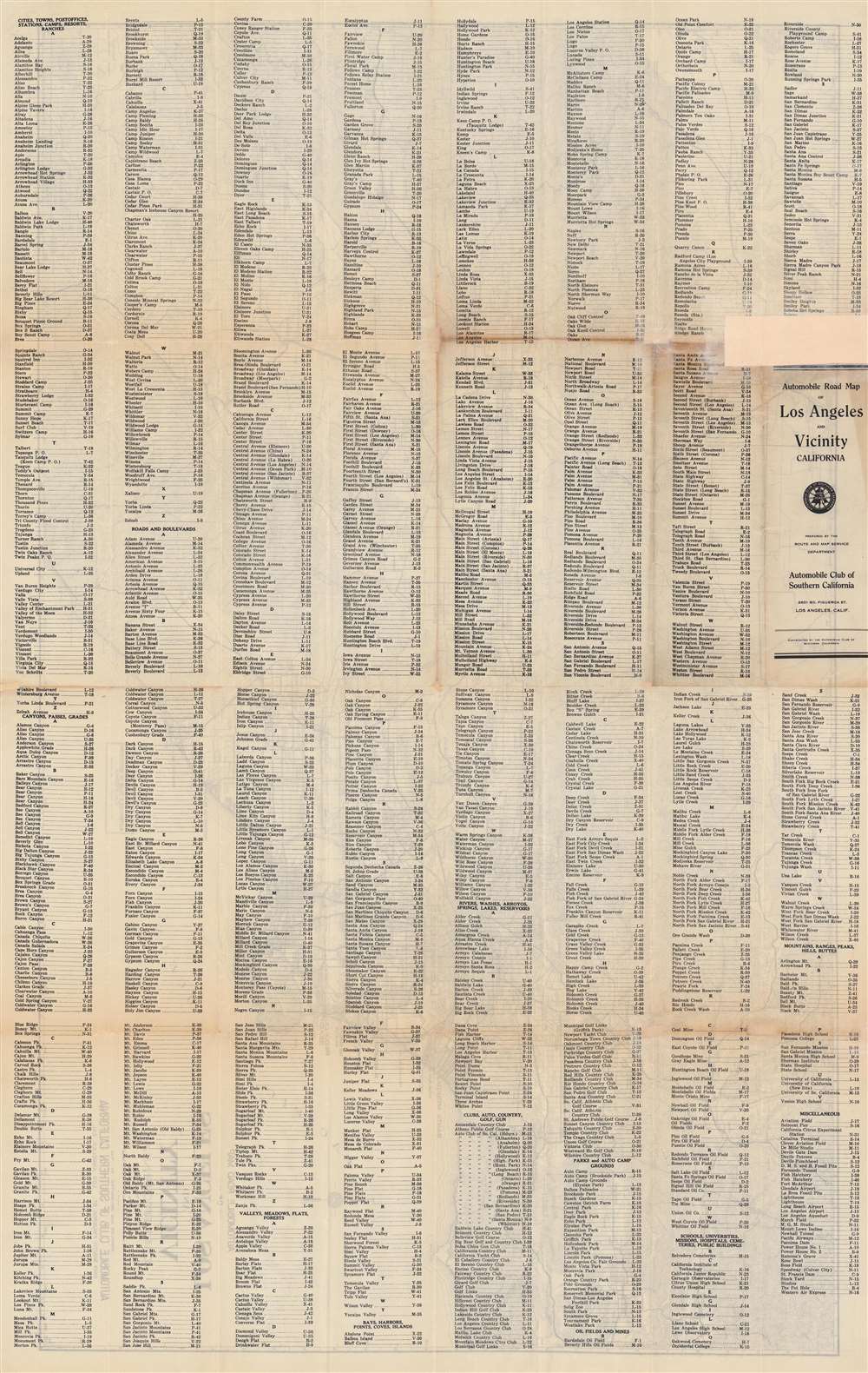
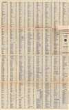
This map is quite distinct from most other Automobile Club of Southern California maps of the era focusing on Los Angeles in that it extends far beyond the built-up portions of Los Angeles and surrounding communities (Santa Monica, Long Beach, Pasadena) into areas that at that time were farmland or sparsely populated forests and mountains. The verso includes a very extensive index of cities, towns, roads, railroads, canyons, waterways, golf courses, oil fields, and more.The Automobile Club of Southern California could be considered part of a late group of L.A. 'boosters' who sought to brandish an image of Southern California as a comfortable paradise fit for relocation from the east coast and Midwest. This vision could conflict with more established residents who wanted to maintain the rustic feel and relatively small population of the region. One prominent example involved what became Malibu, which had been owned by the extremely wealthy local magnate Frederick H. Rindge and his wife Rhoda May Knight Rindge, who fiercely resisted repeated attempts to develop the area. The Rindges even went so far as to build their own railroad and real estate projects to block larger outfits like the Southern Pacific Railway from claiming eminent domain over their lands.
Eventually, the county and state government forced the issue, building a coastal road through the Rindges' ranch in the early 1920s, later upgraded to the Theodore Roosevelt Highway (now the Pacific Coast Highway) and a road (now Kanan Dume Rd./ County Route N9) connecting the coastal road to the State Highway (now U.S.-101). The Rindges won some vindication in the end, as the Southern Pacific never went through Malibu and its successor routes still take an odd inland turn at Oxnard to avoid the area, while Malibu residents have maintained their intense opposition to development that threatens their coastal paradise.
Publication History and Census
This map was published by the Automobile Club of Southern California in the mid-1920s. The exact date is difficult to determine. The lack of Sepulveda Boulevard suggests a date no later than 1925, while the presence of 'Malibu Road' indicates that this map postdates 1921. It differs slightly from the edition held by Stanford University, dated to c. 1924-1925, which has U.C.L.A. in Westwood as 'University of California, Sou. Branch' whereas here it is 'University of California at L.A.' Westwood was chosen as a new site for the school (previously on Vermont Ave. closer to downtown, now L.A. City College) in 1925 and constructed beginning in 1927, so the map must date from after the choice of campus location had been made. Other examples of the present edition may fall under two listings in the OCLC, in both cases held by the same six institutions and very scarce to the market.Cartographer
The Automobile Club of Southern California (1900 - Present) is an auto club based in Los Angeles, California and an affiliate of the American Automobile Association (AAA). Founded in 1900, it was one of the first auto clubs in the United States and was dedicated to proposing traffic laws, improving road conditions, and the overall improvement of driving conditions. The Auto Club began producing its own maps in 1910, when it sent out its own team of cartographers to survey the state's roads. Its main office at the corner of Figueroa Street and Adams Boulevard was completed in 1923. Numbering nearly 8 million members in its home territory alone, today it is the largest single member of the AAA federation More by this mapmaker...
Condition
Good. Discoloration and wear along fold lines. Previous repair on verso towards top-right.
References
OCLC 977654429, 1260161291.