This item has been sold, but you can get on the Waitlist to be notified if another example becomes available, or purchase a digital scan.
1803 Poirson Map of the Mississippi River Valley (French Louisiana)
Louisiana-poirson-1803$487.50

Title
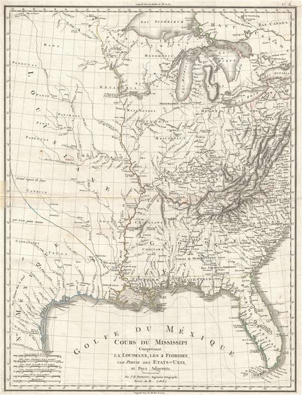
Cours Du Mississipi Comprenant La Louisiane, Les 2 Florides, Une Partie Des Etats-Unis, et Pays Adjacents.
1803 (dated) 21.5 x 16.5 in (54.61 x 41.91 cm) 1 : 5068800
1803 (dated) 21.5 x 16.5 in (54.61 x 41.91 cm) 1 : 5068800
Description
A scarce 1803 map by Jean-Baptiste Poirson illustrating French Louisiana on the cusp of the Louisiana Purchase. Centered on the Mississippi River Valley, the map extends from the Great Lakes to the Gulf of Mexico, including parts of Texas, both East and west Florida, and contiguous parts of the United States. The map is primarily noteworthy for its illustration of the fading Franco-Spanish presence in Louisiana.
The Louisiana Purchase
The Louisiana Territory was ceded to Spain when France lost the French and Indian War. In 1800, Napoléon Bonaparte, then First Consul of the French Republic, reacquired the territory with the intention of re-establishing the French New World empire. Meanwhile, French naval and military might, then focused on European wars, were unable to suppress the Haitian Revolution (1791 – 1804). With war pending with Great Britain, Napoléon decided that selling the territory for a much-needed cash infusion was a better idea than committing his armies to the defense of floundering New World colonies. The Louisiana Purchase, a historic expansion of U.S. Territory followed in 1803, just after this map was issued.
Cartographic Analysis
Cartographically this map was criticized in its day for relying too heavily on mediocre Spanish maps as source material. Particularly as regards the river systems west of the Mississippi, there are numerous inaccuracies, including the absence of the Platte River. Nonetheless, the map takes pains o identify American Indian nations, settlements, and territories throughout. It also identified French Forts, most of which were in ruins, along the course of the Mississippi. The map also identifies East and West Florida, then under tenuous Spanish control, as they would remain until the 1821 Seminole Wars of 1821 and the actualization of the Adams–Onís Treaty.
This map was engraved by Jean Baptiste Poirson in 1803 and published in Pierre-Étienne Herbin de Halle's Statistique Generale et Particulare de la France et ses Colonies.
Cartographer
Jean-Baptiste Poirson (March 6, 1761 – February 12, 1831) was a French engineer, globe-maker, geographer, and cartographer active in the late 18th and early 19th centuries. Poirson was born in Vrécourt (Vosages), France, the son of the town's master blacksmith, Pierre Poirson. Completing his studies in mathematics, Poirson took a position with the map publisher Edme Mentelle (1730 - 1815). From about 1790, maps begin appearing under the Poirson imprint. Having attained some recognition for correcting the work of earlier geographers, Porison was part of a team that collaborated on a large terrestrial globe for the instruction of the Dauphin. After 1803, he was again called on to produce an updated globe, this time for Napoleon Boneparte (this globe is preserved at Fontainebleau). Among his more significant works are the maps associated with the French edition of Alexander von Humboldt's Atlas Geographique Et Physique Du Royaume De La Nouvelle-Espagne. He also worked with Conrad Malte-Brun (1775 - 1826) and François-Raymond-Joseph de Pons (1751 - 1812). In 1825, Poirson and his wife settled in Valence-en-Brie (Seine-et-Marn), purchasing a house on the main street, today's Rue André-Taboulet. He died there in1831 and was survived by his son, the famous French playwright Charles-Gaspard Delestre-Poirson (1790 – 1859). More by this mapmaker...
Source
Halle, Pierre-Étienne Herbin de, Statistique generale et particulare de la France et ses colonies… (Paris) 1803.
Condition
Very good. Minor repair left side. Some wear on original fold lines. Margin repair upper right corner.
References
OCLC 10341772. Wheat, C. I., Mapping of the Transmississippi West, 1540 – 1861, 257. Lowery, W., The Lowery Collection, 741.