This item has been sold, but you can get on the Waitlist to be notified if another example becomes available, or purchase a digital scan.
1833 S.D.U.K. Map of Louisiana, Mississippi, and Alabama
LouisianaArkansas3-sduk-1833$87.50

Title
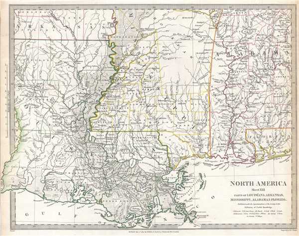
North America Sheet XIII Parts of Louisiana, Arkansas, Mississippi, Alabama and Florida.
1833 (dated) 13.75 x 16.25 in (34.925 x 41.275 cm) 1 : 1770000
1833 (dated) 13.75 x 16.25 in (34.925 x 41.275 cm) 1 : 1770000
Description
This is an uncommon 1833 Society for the Diffusion of Useful Knowledge or S.D.U.K. map of Mississippi, Louisiana, and Alabama, including a major portion of the states of Louisiana, Mississippi and Alabama, along with parts of Arkansas and Florida. The map depicts the region from Lake Sabine and the Sabine river to Choctawhatchee Bay and from Hempstead Country, Arkansas to the Gulf of Mexico. Numerous cities, towns, and villages throughout the region are labeled, along with rivers, lakes, , and other physical features. Counties within each state are illustrated and labeled. Several Indian tribes, including the Choctaw, are identified.
This map is particularly interesting and important due to its portrayal of the rapidly changing American Indian situation in the northern part Mississippi. In 1827, most of northern Mississippi was a confined territory assigned to the Chickasaw and Choctaw Indian Nations. Within only a few years of this map's publication, the Chickasaw and Choctaw Nations were forcibly relocated westward in the infamous 'Trail of Tears.'
This map was created for the Society for the Diffusion of Useful Knowledge, engraved by the firm of John and Charles Walker, and published by Baldwin and Cradock on June 1, 1833.
CartographerS
The "Society for the Diffusion of Useful Knowledge" (1826 - 1848) was a Whiggish organization founded in 1828 at the instigation of idealistic British lord Henry Peter Brougham. The admirable goal of the Society was to distribute useful information via a series of publications to the English working and middle classes. It promoted self-education and the egalitarian sharing of all knowledge. While closely tied to the London University and publishing houses on the order of Baldwin and Cradock, Chapman and Hall, and Charles Knight, the Society failed to achieve its many lofty goals in finally closed its doors in 1848. Most likely the failure of the Society resulted from its publications being too expensive for its intended lower to middle class markets and yet not large and fine enough to appeal to the aristocratic market. Nonetheless, it did manage to publish several extraordinary atlases of impressive detail and sophistication. Their most prominent atlas consisted of some 200 separately issued maps initially published by Baldwin and Cradock and sold by subscription from 1829 to 1844. Afterwards, the Society combined the maps into a single world atlas published under the Chapman and Hall imprint. In its day, this atlas was unprecedented in its quality, scope, and cost effectiveness. Today Society, or S.D.U.K. as it is commonly known, maps are among the most impressive examples of mid-19th century English mass market cartographic publishing available. The S.D.U.K. is especially known for its beautiful and accurately detailed city plans. More by this mapmaker...
John Walker (1787 - April 19, 1873) was a British map seller, engraver, lithographer, hydrographer, geographer, draughtsman, and publisher active in London during the 19th century. Walker published both nautical charts and geographical maps. His nautical work is particularly distinguished as he was an official hydrographer for the British East India Company, a position, incidentally, also held by his father of the same name. Walker's maps, mostly published after 1827, were primarily produced with his brothers Charles Walker and Alexander Walker under the imprint J. and C. Walker. Among their joint projects are more than 200 maps for the influential Society for the Diffusion of Useful Knowledge Atlas (SDUK). In addition they published numerous charts for James Horsburgh and the British Admiralty Hydrographic Office, including Belcher's important map of Hong Kong and Carless' exploratory map of Karachi. The J. and C. Walker firm continued to publish after both Walkers died in the 1870s. Learn More...
Baldwin and Cradock (fl. c. 1810 - 1860) were London based publishers working in the early to mid 19th century. They are best known for their publication of the Society for the Diffusion of Useful Knowledge's ground breaking subscription atlas. They also published John Thomson's magnificent New General Atlas from 1814 - c. 1820. In addition to their cartographic corpus, the firm had wide ranging publishing interests in many other areas, including books, broadsides, and an investment in Blackwoods Magazine. They had their offices at 47 Paternoster Row, London, England. This firm also published under the imprint Baldwin, Cradock, and Joy and Cradock and Joy. Learn More...
Condition
Very good. Even overall toning. Blank on verso.
References
Rumsey 0890.140 (atlas edition)