1803 Duvallon Narrative on Spanish Louisiana and West Florida w/ 2 Maps
LouisianeFloride-duvallon-1803$3,400.00


Title
Vue de la colonie Espagnole du Mississipi, ou des provinces de Louisiane et Floride Occidentale, en l'année 1802 de Louisiane et Floride occidentale, en l'année 1802, par un observateur résidant sur les lieux.
1803 (dated) x in (0 x 0 cm)
1803 (dated) x in (0 x 0 cm)
Description
This is Pierre-Louis Berquin Duvallon's 1803 travel narrative describing Spanish-administered Louisiana and West Florida on the cusp of the Louisiana Purchase. The work offers an entertaining and often critical account of political, economic, and social life in New Orleans between 1800 and 1802. It also includes two important maps, being among the few specific maps of Upper and Lower Louisiana and West Florida during the Spanish period.
Word of the retrocession did not reach U.S. Diplomatic circles until 1801, and then only in rumors. Fearing that France would renege on Spanish-American treaties guaranteeing the United States access to the Mississippi River and rights of deposit in New Orleans, then President Thomas Jefferson initiated diplomatic talks with French Emperor Napoleon Bonaparte to acquire New Orleans. Talks initially languished as Napoleon's troops attempted to suppress the revolution on Saint-Domingue (Haiti), which they considered to be the more significant territory. When French forces were soundly defeated by the Haitian revolutionary leader Jean-Jacques Dessalines in 1802, Napoleon relegated Louisiana to a redundancy and agreed to the Louisiana Purchase, transferring the territory to the United States on December 20, 1803.
A Closer Look
This is the first edition of the book in its original full leather binding. The binding is heavily worn and scuffed but intact. Contains some 318 pages, plus supplementary material and errata. There are two significant maps - see below. Streeter (1530) describes the work:This gives an entertaining and gossipy first-hand picture of life in New Orleans at the turn of the century; its theatrical companies, dances, the high status of medical doctors, gaucheries of the Creoles, and so on. At the end there are general accounts of the natural features of Louisiana, its commerce, and other general subjects. Its two colored maps, one of lower, the other of upper Louisiana to the Falls of St. Anthony are well worth while. (Streeter Sale #1530).
Love Hate Affair with New Orleans
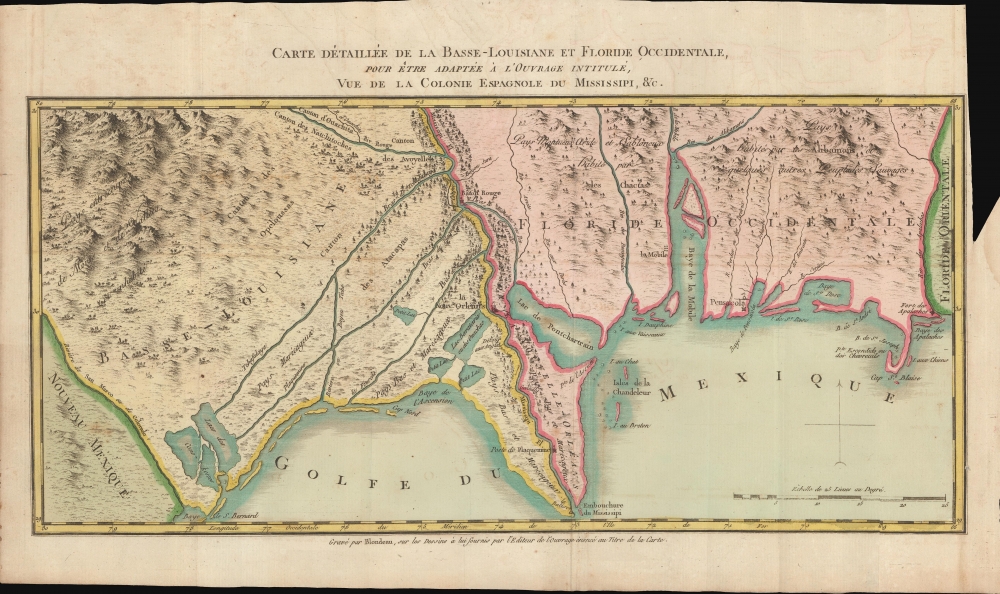
Duvallon had a love-hate relationship with Louisiana in general, and New Orleans specifically. His initial low opinion was likely spurred by his run-ins with the law regarding his importation of illegal Haitian slaves. He dwells on New Orleans over several chapters, which he describes as a ramshackle city with streets little better than open sewers. He seems to have been both scandalized and fascinated by the city's nightlife, calling the citizens amoral drunks bereft of education and manners, given to lewd dancing and nonstop gambling. He was particularly bothered by the free mixing of the races, as well as freemen and slaves. However, given the amount of pen-time he dedicates to these topics, it is clear he spent a good deal of time engaged in such activities.Map: West Florida and Lower Louisiana
The work's primary map Carte Detaillee de la Basse-Louisiane et Floride Occidentale, pour etre adaptee a l'ouvrage intitule, Vue de la Colonie Espagnole du Mississippi is one of the best specific maps capturing Louisiana on the cusp of the Louisiana Purchase. It was engraved by Alexandre Blondeau. It captures the southern part of Spanish Louisiana and West Florida. Centered on the Mississippi River and New Orleans, coverage embraces from what is here named the 'Rio de San Marco ou de Colorado', likely the Sabine River, and just to the east, Lake Calcasieu (Lacs des Cono-Kosses), east past Mobile Bay and Pensacola, as far as the Apalachicola River (Rio des Apalaches). The territory is divided by the Mississippi River into 'Basse-Louisiane' and 'Floride Occidentale'. New Orleans, Baton Rouge, Mobile, Pensacola, Poste de Plaquemine (Plaquemines Parish), and Fort Apalache are named.Map: Upper Louisiana
The second smaller map covers upper Louisiana or, Haute-Louisiane. It too was engraved by Alexandre Blondeau. Centered on the Mississippi, coverage embraces from the Falls of St. Anthony to Natchez. Lakes Superior and Michigan are embryonically illustrated. St. Louis, New Madrid, St. Genevieve, the 'Poste de Arcs ou Arkansas', and Natchez are identified. Territory is divided between Spanish-administered Haute-Louisiane to the west, described as 'vast countries little known', and the Etats-Unis (United States) to the east. Kentucky is named at the confluence of the Ohio with the Mississippi River. To the north of Kentucky, the 'Territoire du Nord Ouest' is noted, a reference to the 1787 Northwest Ordnance. Effort has been made to map the Missouri, but from this image, it is clear that the full extent of that river remained unknown. The map underscores the significance of the Mississippi River as a trade artery between the Great Lakes, and hence the Atlantic, and the Gulf of Mexico.Historical Context
By the time Duvallon arrived in New Orleans in 1800, Spain had already retroceded Louisiana to France through the Third Treaty of San Ildefonso. However, the agreement was a state secret in both countries and there would have been little evidence of the exchange in New Orleans, which, according to the treaty, continued to be governed by Spain through 1803.Word of the retrocession did not reach U.S. Diplomatic circles until 1801, and then only in rumors. Fearing that France would renege on Spanish-American treaties guaranteeing the United States access to the Mississippi River and rights of deposit in New Orleans, then President Thomas Jefferson initiated diplomatic talks with French Emperor Napoleon Bonaparte to acquire New Orleans. Talks initially languished as Napoleon's troops attempted to suppress the revolution on Saint-Domingue (Haiti), which they considered to be the more significant territory. When French forces were soundly defeated by the Haitian revolutionary leader Jean-Jacques Dessalines in 1802, Napoleon relegated Louisiana to a redundancy and agreed to the Louisiana Purchase, transferring the territory to the United States on December 20, 1803.
Publication History and Census
This book was originally published in Paris, in French, in 1803. A German edition followed in 1804, and an English edition was published in New York in 1806. A second French edition appeared in 1808. The present example is the 1803 first edition. It has a collection stamp on the title page identifying David Denne (1845 - 1903) of Montreal. Denne was a private collector of books, maps, and manuscripts. His private collection was auctioned in Montreal in 1908 by Walter M. Kearns - it is not clear if this book was in that auction. The work is well represented in institutions, but scarce to the market.CartographerS
Pierre-Louis Berquin Duvallon (1769 - 1814) was a French sugar planter and procureur du roi in French Santo Domingo before the Haitian Revolution (1791 - 1804). Berquin-Duvallon was born in Santo Domingo. In 1793 in the Revolution he fled to Baltimore - specifically as Maryland allowed him to bring and keep his slaves. (Louisiana, of note, did not allow the import of Haitian slaves after the 1791, for fear they would spread revolutionary sentiment.). In 1800, he travled to New Orleans, where he found trouble with the law as he brought his illegal Haitian slaves. Nonethless, he traveled through Louisiana, and purchased a plantation on the Tchoupitoulas Coast. It was there that he wrote the travel account for which he is best remembered, Vue de la Colonie Espagnole du Mississipi ou des provinces de Louisiane et Floride Occidentale en l’an 1802. More by this mapmaker...
Alexandre Blondeau (fl. c. 1799 - 1828) was a French line engraver based in Paris. In 1816 during the reign of Louis XVIII, he was appointed 'Graveur du Roi' and 'Premier Graveur du Dépot de la Guerre'. His apprentices include the topographical engraver Pierre Léonard Dandeleux (1783 - 1850). Learn More...
Source
Duvallon, Pierre-Louis Berquin, Vue de la colonie Espagnole du Mississipi, ou des provinces de Louisiane et Floride Occidentale, en l'année 1802 de Louisiane et Floride occidentale, en l'année 1802, par un observateur résidant sur les lieux, (Paris: Imprimerie Expéditive) 1803.
Condition
Good. Original binding heavily worn but intact. Contains both called for maps. Pages exhibit mild toning and light foxing. Maps are both in excellent condition.
References
OCLC 1646308. Howes, W., U.S.iana (1650-1950): A Selective Bibliography in which are Described 11,620 Uncommon and Significant Books Relating to the Continental Portion of the United States, #B389. Sabin, J., Biblioteca Americana. A Dictionary of Books Relating to America, from its Discovery to Present Time, (29 vols) #4962. Streeter, T. W., The celebrated collection of Americana formed by the late Thomas Winthrop Streeter, #1530. Leclerc, C., Bibliotheca Americana, #1038.