This item has been sold, but you can get on the Waitlist to be notified if another example becomes available, or purchase a digital scan.
1920 Manuscript Wall Map of Florida and Louisiana
Louissianne-unknown-1920$2,400.00


Title
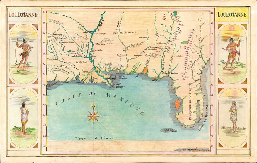
Loüissianne.
1920 (undated) 27.25 x 42.75 in (69.215 x 108.585 cm) 1 : 2455000
1920 (undated) 27.25 x 42.75 in (69.215 x 108.585 cm) 1 : 2455000
Description
A striking and impressively proportioned cartographic curiosity, this is a c. 1920 manuscript map of Florida and the Gulf Littoral as far as Texas. The image is surrounded by front and back-facing images of American Indians. Most likely this is the original art for an unpublished educational poster, as it exhibits a professional level of execution. The map is drawn in ink with color added using what appears to be colored pencil or pastels.
Sources - the Map
The map is based upon the rare 1715 first edition of Nicolas De Fer's map of the southern part of North America, La Riviere De Missisipi, et ses Environs. This is itself of great curiosity, as the 1715 De Fer is an entirely different map from the more common 1718 De Fer, and surviving examples are known in only 2 or 3 collections. The artist must have had access to one of the few surviving first editions to complete this map. Despite its rarity, the 1715 map is one of the most important early maps of the Mississippi Valley. It is the first map to introduce significant new cartographic information regarding the Lower Mississippi and surrounding areas based on the first-hand accounts of Jesuit missionaries and other explorers, including Françoise Le Maire, Louis Hennepin (1626 - 1704), René-Robert Cavelier Sieur de La Salle (1643 - 1687), and Louis Jolliet (1645 - 1700), among others. It also offers a unique illustration of Florida including a large island, here colored orange, roughly corresponding to an erroneous connection of Charlotte Harbor and Tampa Bay. On the opposite side of Florida vast inlet attempts to illustrate the inter-coastal waterways and the Key Biscayne / Miami area.Sources - the American Indian Images
The surrounding images of indigenous American Indians are based upon illustrations John White, first published in Theodore De Bry's 1590 collection of travel narratives, America, part of his Les Grands Voyages series. The man with a bow is a lord of the Werowan peoples of Virginia - first encountered and illustrated by John White. The woman, also by White, is 'of the Chieff Ladyes of Secota' - however, the original image is topless, suggesting the author of this image had more puritanical sensibilities.Publication History and Census
As a manuscript, this map is unique. We have discovered no evidence that it was ever published. The map is accompanied by an official 'Certificat d'Exportation' from the government of France.Cartographer
Nicholas de Fer (1646 - October 25, 1720) was a French cartographer and publisher, the son of cartographer Antoine de Fer. He apprenticed with the Paris engraver Louis Spirinx, producing his first map, of the Canal du Midi, at 23. When his father died in June of 1673 he took over the family engraving business and established himself on Quai de L'Horloge, Paris, as an engraver, cartographer, and map publisher. De Fer was a prolific cartographer with over 600 maps and atlases to his credit. De Fer's work, though replete with geographical errors, earned a large following because of its considerable decorative appeal. In the late 17th century, De Fer's fame culminated in his appointment as Geographe de le Dauphin, a position that offered him unprecedented access to the most up to date cartographic information. This was a partner position to another simultaneously held by the more scientific geographer Guillaume De L'Isle, Premier Geograph de Roi. Despite very different cartographic approaches, De L'Isle and De Fer seem to have stepped carefully around one another and were rarely publicly at odds. Upon his death of old age in 1720, Nicolas was succeeded by two of his sons-in-law, who also happened to be brothers, Guillaume Danet (who had married his daughter Marguerite-Geneviève De Fer), and Jacques-François Bénard (Besnard) Danet (husband of Marie-Anne De Fer), and their heirs, who continued to publish under the De Fer imprint until about 1760. It is of note that part of the De Fer legacy also passed to the engraver Remi Rircher, who married De Fer's third daughter, but Richer had little interest in the business and sold his share to the Danet brothers in 1721. More by this mapmaker...
Condition
Very good. Even toning. Old pinholes in corners.