1846 Bradford Map of Lower Canada (Quebec), New Brunswick, and Nova Scotia
LowerCanada-bradford-1846$275.00

Title
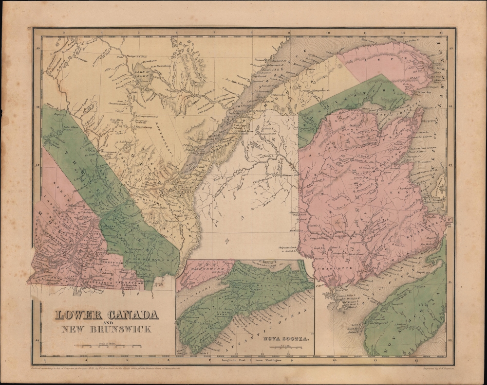
Lower Canada and New Brunswick.
1846 (dated) 11.5 x 14.25 in (29.21 x 36.195 cm) 1 : 2217600
1846 (dated) 11.5 x 14.25 in (29.21 x 36.195 cm) 1 : 2217600
Description
A nice example of Thomas Bradford's 1846 map of Lower Canada (Quebec), New Brunswick, and Nova Scotia, that appeared in his Universal Illustrated Atlas.
Still, intense opposition remained, with sporadic fighting by Quebecois patriotes continuing throughout the 1840s. At the same time, efforts to assuage separatist sentiment (namely the Rebellion Losses Bill) incensed British Tories, who felt they were being asked to compensate rebels for losses in a war they had initiated. The Tories group went so far as to riot and burn down the Parliament Building of the new province in Montreal in 1849, causing the government to relocate the capital of Canada to Toronto.
As for New Brunswick, it had been sparsely populated for much of its history as a European colony, but was growing rapidly at this time. Heavily wooded and otherwise lacking in valuable resources, the colony became the destination for tens of thousands of immigrants from Scotland and Ireland fleeing crop famine, land clearances, and other woes, seeking land and a new life in the Americas. Nova Scotia received more government largesse due to its strategic location, and moreover benefited from ready access to large fish stocks in the North Atlantic. It achieved responsible government (significant autonomy) in 1848, the first colony anywhere in the British Empire to do so.
A Closer Look
Taking in the southeastern part of today's Canada, this map covers Lower or Eastern Canada (now Quebec), New Brunswick, and Nova Scotia in an inset at bottom. Districts are color shaded for easy distinction, with internal administrative divisions (counties) marked with dashed lines. Towns and settlements are marked throughout, along with geographic features. The meandering border between Quebec and Maine seen here reflects uncertainties and disputes of previous decades; although the border had been fixed by the Webster-Ashburton Treaty of 1842, Bradford appears to have been unconvinced that the settlement was final.Historical Context
Canadian provinces and territories were under British and French control from the 16th century, until France gave up its claims in the Treaty of Paris in 1763. In 1791, under the Constitutional Act, the Province of Quebec was divided into Upper and Lower Canada. When this map was produced, the British were reeling from an armed uprising in Lower Canada in 1837-1838 (known locally as the Guerre des patriotes), which coincided with a rebellion in Upper Canada. Following the suppression of the rebellion and imposition of martial law, Lower Canada was united with Upper Canada as the Province of Canada in 1840, largely to dilute the political power of the French-speaking community. (They continued to be informally referred to as Upper and Lower Canada, or 'Canada West' and 'Canada East').Still, intense opposition remained, with sporadic fighting by Quebecois patriotes continuing throughout the 1840s. At the same time, efforts to assuage separatist sentiment (namely the Rebellion Losses Bill) incensed British Tories, who felt they were being asked to compensate rebels for losses in a war they had initiated. The Tories group went so far as to riot and burn down the Parliament Building of the new province in Montreal in 1849, causing the government to relocate the capital of Canada to Toronto.
As for New Brunswick, it had been sparsely populated for much of its history as a European colony, but was growing rapidly at this time. Heavily wooded and otherwise lacking in valuable resources, the colony became the destination for tens of thousands of immigrants from Scotland and Ireland fleeing crop famine, land clearances, and other woes, seeking land and a new life in the Americas. Nova Scotia received more government largesse due to its strategic location, and moreover benefited from ready access to large fish stocks in the North Atlantic. It achieved responsible government (significant autonomy) in 1848, the first colony anywhere in the British Empire to do so.
Publication History
Despite the date of the copyright at bottom-left, this map (engraved by George Washington Boynton) was published in the 1846 edition of Bradford's Universal Illustrated Atlas.CartographerS
Thomas Gamaliel Bradford (1802 - 1887) was born in Boston, Massachusetts, where he worked as an assistant editor for the Encyclopedia Americana. Bradford's first major cartographic work was his revision and subsequent republishing of an important French geography by Adrian Balbi, Abrege de Geographie published in America as Atlas Designed to Illustrate the Abridgment of Universal Geography, Modern and Ancient. Afterwards Bradford revised and expanded this work into his own important contributions to American cartography, the 1838 An Illustrated Atlas Geographical, Statistical and Historical of the United States and Adjacent Countries. Bradford's cartographic work is significant as among the first to record Texas as an independent nation. In his long career as a map publisher Bradford worked with William Davis Ticknor of Boston, Freeman Hunt of New York, Charles De Silver of Philadelphia, John Hinton, George Washington Boynton, and others. We have been able to discover little of Bradford's personal life. More by this mapmaker...
George Washington Boynton (fl. c. 1830 - 1850) was a Boston based cartographer and map engraver active in the first half of the 19th century. Boynton engraved and compiled maps for numerous publishers including Thomas Bradford, Nathaniel Dearborn, Daniel Adams, and S. G. Goodrich. His most significant work is most likely his engraving of various maps for Bradford's Illustrated Atlas, Geographical, Statistical, and Historical, of the United States and the Adjacent Countries and Universal Illustrated Atlas. He also engraved for the Boston Almanac. In 1835, Boynton is listed as an employee of the Boston Bewick Company, an engraving, stereotype, and printing concern based at no. 47 Court Street, Boston. Little else is known of his life. Learn More...
Source
Bradford, T. G. and Goodrich, S. G., A Universal Illustrated Atlas, exhibiting a Geographical, Statistical, and Historical view of the World, (Boston: Charles D. Strong) 1846.
The Universal Illustrated Atlas is one of the great American atlases of the first half of the 19th century. The atlas was first published in 1838 under the imprint of Charles D. Strong. It replaced and superseded Bradford's earlier smaller format Illustrated Atlas, Geographical, Statistical, and Historical, of the United States and the Adjacent Countries. Numerous reissues of the Universal Illustrated Atlas followed until about 1848. Although there are minor variations between the editions, most contain about 50 maps, the majority of which focus on the United States. Bradford's atlases are significant for recording North America during the Republic of Texas Era. In later editions, particularly the 1846 edition, Bradford illustrates the boom in railroad construction, possibly with the idea that his maps would aid travelers in planning journeys by rail. It was compiled by Thomas Gamaliel Bradford and Samuel Griswold Goodrich with most of the plates engraved by George Washington Boynton (fl. c. 1830 - 1850). Other contributors include Thomas Gordon (1778 - 1848), Fielding Lucas Jr. (1781 - 1854), Samuel Edward Stiles (1844 - 1901), Sherman and Smith (fl. c. 1829 - 1855), and Horace Thayer (1811 - c. 1874).
Condition
Good. Light foxing and soiling.
References
Rumsey 4453.005 (1841 edition).