1849 Greenleaf Map of Lower Canada (Quebec)
LowerCanada-greenleaf-1849$250.00

Title
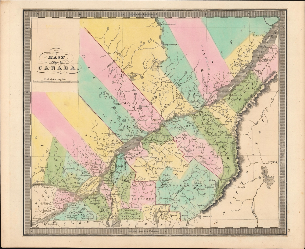
East Part of Canada.
1849 (undated) 10.75 x 12.75 in (27.305 x 32.385 cm) 1 : 1440000
1849 (undated) 10.75 x 12.75 in (27.305 x 32.385 cm) 1 : 1440000
Description
A bright, colorful example of Jeremiah Greenleaf's 1849 map of Lower Canada (Quebec). It was published at a time when tensions between Francophone and Anglophone residents of these territories, and between both groups and the British administration, were simmering.
Still, intense opposition remained, with sporadic fighting by patriotes continuing throughout the 1840s. At the same time, efforts to assuage separatist sentiment (namely the Rebellion Losses Bill) incensed British Tories, who felt they were being asked to compensate rebels for losses in a war they had initiated. The Tories group went so far as to riot and burn down the Parliament Building of the new province in Montreal in 1849, the same year this map was published, causing the government to relocate the capital of Canada to Toronto.
A Closer Look
Centered on the St. Lawrence River, the map covers the territories of Lower Canada, including much of today's Quebec. Throughout, various cities, rivers, mountains, forts, and an assortment of additional topographical details are recorded. The borders between counties (known today as regional county municipalities) and districts (Montreal 3 Rivers, and Quebec) are noted with color shading. The city of Montreal is prominent towards bottom-left, with the important Lachine Canal (completed 1824) labeled, while the city of Quebec can be seen along the St. Lawrence towards right.Historical Context
Canadian provinces and territories were under British and French control from the 16th century, until France gave up its claims in the Treaty of Paris in 1763. In 1791, under the Constitutional Act, the Province of Quebec was divided into Upper and Lower Canada. When this map was produced, the British were reeling from an armed uprising in Lower Canada in 1837-1838 (known locally as the Guerre des patriotes), which coincided with a rebellion in Upper Canada. Following the suppression of the rebellion and imposition of martial law, Lower Canada was united with Upper Canada as the Province of Canada in order to dilute the political power of the French-speaking community (they continued to be informally referred to as Upper and Lower Canada, or 'Canada West' and 'Canada East').Still, intense opposition remained, with sporadic fighting by patriotes continuing throughout the 1840s. At the same time, efforts to assuage separatist sentiment (namely the Rebellion Losses Bill) incensed British Tories, who felt they were being asked to compensate rebels for losses in a war they had initiated. The Tories group went so far as to riot and burn down the Parliament Building of the new province in Montreal in 1849, the same year this map was published, causing the government to relocate the capital of Canada to Toronto.
Publication History and Census
This map was published by Jeremiah Greenleaf in the scarce 1849 (last) edition of his New Universal Atlas. It is based on David Burr's 1834 original, which was published in the latter's atlas of the same name, before being inherited and updated by Greenleaf, who published it in several editions in the 1840s.CartographerS
Jeremiah Greenleaf (1791 - 1864) is a little known but highly admired American cartographer of the early 19th century. He published from roughly 1830 to 1850. His most important work is A New Universal Atlas; Comprising of all the Principal Empires, Kingdoms, and States Throughout the World and Forming a distinct Atlas of the United States, published in several editions in the 1840s. Many of his maps are reformatted versions of his contemporary David Burr's much admired cartographic works. Greenleaf's maps are extremely rare and admired for their stunningly vivid pastel color washes. More by this mapmaker...
David Hugh Burr (August 18, 1803 - December 25, 1875) of one of the first and most important truly American cartographers and map publishers. Burr was born in Bridgeport Connecticut in August of 1803. In 1822 Burr moved to Kingsboro, New York to study law. A year and a half later he was admitted to the New York Bar association. Burr must have questioned his choice of careers because shortly after being admitted to the Bar, he joined the New York State Militia. Though largely untrained in the art of surveying, Burr was assigned to work under Surveyor General of New York, Simeon De Witt, to survey several New York Roadways. Seeing a window of opportunity, Burr was able to negotiate with the governor of New York at the time, De Witt Clinton, to obtain copies of other New York survey work in order to compile a map and Atlas of the state of New York. Recognizing the need for quality survey work of its territory, the government of New York heartily endorsed and financed Burr's efforts. The resulting 1829 Atlas of the State of New York was the second atlas of an individual U.S. state and one of the most important state atlases ever produced. Burr went on to issue other maps both of New York and of the United States in general. In cooperation with publishing firm of Illman & Pillbrow, he produced an important New Universal Atlas and, with J.H. Colton, several very important maps of New York City. In recognition of this work, Burr was appointed both "Topographer to the Post office" and "Geographer to the House of Representatives of the United States". Later, in 1855, Burr was assigned to the newly created position of Surveyor General to the State of Utah. Burr retired from the position and from cartographic work in general in 1857 when light of some of his financial misdeeds and frauds came to light. He was accused of submitting false expense reports and underpaying employees, among other indiscretions. Learn More...
Source
Greenleaf, J., New Universal Atlas, (Brattleboro, Vermont: Greenleaf) 1849.
Condition
Very good.
References
Rumsey 15176.034.