This item has been sold, but you can get on the Waitlist to be notified if another example becomes available, or purchase a digital scan.
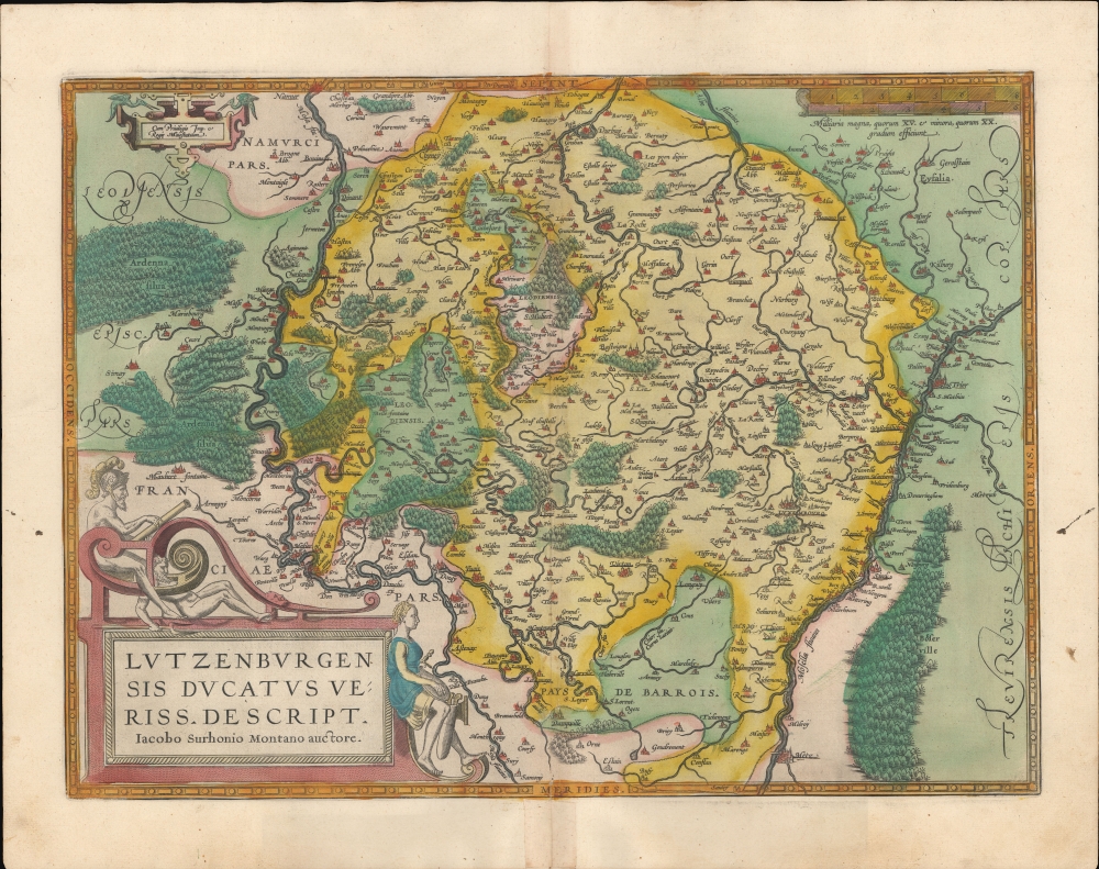
1595 Ortelius Map of Luxembourg
Luxembourg-ortelius-1595$700.00


Title
Lutzenburgensis Ducatus Veriss Descript.
1595 (undated) 14 x 20 in (35.56 x 50.8 cm) 1 : 400000
1595 (undated) 14 x 20 in (35.56 x 50.8 cm) 1 : 400000
Description
A beautiful example, in superb original color, of Abraham Ortelius' map of Luxembourg. It is considered the first map of those areas presented in an atlas. While the book's first edition was released in 1570, Ortelius continually improved the work - both by adding new maps, and by refining the production of the book. Maps appearing in editions of the Theatrum in the 1580s and 1590s generally display, as here, a finer quality of color than those in the earlier issues of the work.
Sources
This map is based on a 1551 map of Luxembourg made by Jean de Surhon for Holy Roman Emperor Charles V (1500 - 1558) in 1551. Seen as a threat to state security, the Surhon map was never published - at least, not until 1579, when Antwerp was briefly independent. At that time, Ortelius used Surhon as a source, producing this map. Other sources include geographic data by Tilemanus Stella Sigensis (not previously published), by Christian Schrot, and Ioannes Scillius (not previously published).Historical Context
In the late 1500s, Luxembourg was tumultuously caught between the great powers of Europe. It was a period dominated by the Habsburgs, under whose rule the territory was a part of the Spanish Netherlands. The Protestant Reformation, which was sweeping through Europe, also touched Luxembourg, leading to religious tensions and conflicts. Strategically positioned, Luxembourg was a coveted prize and often became a battleground between the rivaling powers, particularly during the Eighty Years’ War (1568 - 1648) between Spain and the Dutch Republic. Despite these challenges, its fortified city, with impressive walls and bastions, stood as a testament to Luxembourg's resilience and strategic importance.Publication History and Census
This map was engraved and first added to the Ortelius Atlas in 1570. It is the fourth state, corresponding to Ort 60.4, retooled with additional hachuring in the cartouche. The present example conforms typographically to the 1595 Latin edition of the work (1595L35). This map is well represented in institutional collections and appears on the market from time to time.CartographerS
Abraham Ortelius (April 14, 1527 - June 28, 1598) also known as Ortels, was a cartographer, geographer, and cosmographer of Brabant, active in Antwerp. He was the creator of the first modern atlas, Theatrum Orbis Terrarum and is a seminal figure in the history of cartography. Along with Gerard Mercator and Gemma Frisius, he was a founder of the Netherlandish school of cartography. His connections with Spain - culminating in his 1575 appointment as Royal Cartographer to King Phillip II of Spain - gave him unmatched access to Spanish geographical knowledge during a crucial period of the Age of Discovery. Ortelius was born in 1527 in Antwerp. In 1547 he entered the Antwerp Guild of Saint Luke as an illuminator of maps. He began trading in books, prints, and maps, traveling regularly to the Frankfurt book and print fair, where in 1554 he met Mercator. He accompanied Mercator on journeys throughout France in 1560 and it was at this time, under Mercator's influence, that he appears to have chosen his career as a scientific geographer. His first published geographic work appeared in 1564, an eight-sheet cordiform world map. A handful of other maps preceded the 1570 publication of the first edition of the Theatrum Orbis Terrarum, which would prove to be his life work. Appearing with but 53 maps in its first edition, Ortelius' work expanded with new maps added regularly. By 1592, it had 134 maps. Many of Ortelius' maps remained the standard for nearly a century. He traveled extensively, but his genius was as a compiler, locating the best informed maps on which to base his own. His contacts throughout Europe and extending even (via the Portuguese) to the Far East were formidable. Moreover, many of his maps were based on his own scholarship, particularly his historical works. His theories of geography were particularly ahead of his time with respect to the notion of continental drift, the possibility of which he mused on as early as 1596, and which would be proven correct centuries later.
In a sense his greatest achievement was his successful navigation of the religious and political violence endemic to his city throughout his adult life: The Dutch Revolt, or Eighty Years' War (1568 - 1648), fully embroiled Antwerp. Although outwardly and officially recognized as Catholic (Arias Montanus vouched for Ortelius' Catholic orthodoxy prior to his appointment as Royal Geographer), Ortelius was able to separate himself from the religious furor which characterized the war in the low countries. Ortelius showed a glimpse of himself in a letter to a friend, regarding humanist Justus Lipsius: 'I do not know whether he is an adherent of the Pope or a Calvinist, but if he has ears to hear, he will neither be one nor the other, for sins are committed on both sides'. Ortelius' own explorations of Biblical history in his maps, and the Christogram contained in his own motto, suggest him to be a religious man, but his abjuration of political religious authorities mark him as an individualist. His tombstone at St Michael's Præmonstratensian Abbey in Antwerp bears the inscription, Quietis cultor sine lite, uxore, prole. ('served quietly, without accusation, wife, and offspring.') More by this mapmaker...
Jean de Surhon (fl. 1550 - 1600) was a Franco-Flemish engraver and cartographer. His father and brother, both named Jacques, were engravers and cartographers as well: his father was also a silversmith. He is remembered for those of his maps which were incorporated in Ortelius' Theatrum Orbis Terrarum: those of Namur (1553), Vermandois (1557), Luxembourg (1551), and Picardy (1557). The original maps do not appear to have survived, and thus Ortelius' versions are the earliest acquirable to the collector. The first, 1570 edition of the Theatrum contained the map of Vermandois: Namur and Picardy first appeared in the 1579 edition. It is a testament to Surhon's maps that no improvement was made to them until the second half of the seventeenth century: Willem Blaeu's atlas would reprise Surhon's work in a faithful, though more beautiful copy of the Ortelius. Learn More...
Source
Ortelius, A., Theatrum Orbis Terrarum, (Antwerp: Plantin) 1595.
Abraham Ortelius' magnum opus, Theatrum Orbis Terrarum, was the world's first regularly produced atlas, which 'set the standards for later atlases . . . It was the first undertaking of its kind to reduce the best available maps to an uniform format.' (Koeman) A modestly-sized work of fifty-three maps in its first edition of May 1570, it was an immediate success: there were three further editions that year, and the work remained in print for a total of 32 editions, the last of which was 1641, well after its author's 1598 death. Ortelius added to his atlas constantly, and by 1595 the Theatrum contained 147 maps. Ortelius is renowned generally as an editor, and indeed much of the Theatrum is compiled from a variety of sources: in such cases, Ortelius was scrupulous in naming his sources. But Ortelius was also a mapmaker in his own right: many of his maps are a distillation of various sources into his own work, and there were many maps - particularly in his atlas of Biblical and ancient history Parergon - which were entirely Ortelius' work. In his role as an editor, Ortelius followed in the footsteps of Munster, whose Cosmographia was, until Ortelius, the best window on the world for the curious European reader. In terms of the artistry of his maps, Ortelius oversaw the first great flourishing of copperplate engraving in the service of cartography to occur in Northern Europe. Ortelius' work provided the model for the atlases of Mercator, Hondius, Blaeu and all their progeny in the 17th century - many of whom were to produce faithful editions of Ortelius' maps in their own productions.
Condition
Very good. Generous margins. Superb original color. Slight foxing. Minor verso repair, bottom centerfold.
References
Van der Krogt, P. C. J., Koeman's Atlantes Neerlandici, (3 Vols),3380:31. Ord 60.4.