This item has been sold, but you can get on the Waitlist to be notified if another example becomes available, or purchase a digital scan.
1959 Reissue of the Japanese Coprosperity Map of Luzon, the Philippines
Luzon-coprosperity-1959$187.50

Title
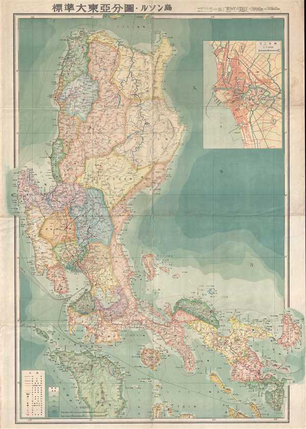
標準大東亞分圖 : ルソン島 / Standard Map of the Great East Asia: Luzon.
1959 (dated) 29.5 x 21.25 in (74.93 x 53.975 cm) 1 : 1000000
1959 (dated) 29.5 x 21.25 in (74.93 x 53.975 cm) 1 : 1000000
Description
A 1959 reissue of an important and rare World War II (WWII) 1943 Showa 18 Japanese Map of the Philippines. The map covers the northern Philippine Island of Luzon. Oceanic depths are illustrated with blue shading. Air and sea routes are identified with distances noted.
The capture and control of the Philippines was vital to the success of Japanese plan to dominate the Pacific. Not only was the archipelago rich in natural resources, including rubber, oil, mineral resources, and wood, it was also centrally located and well positioned for expansion into the West Indies. Moreover, wresting control of the Philippines from the United States would have effectively undermined the American ability to wage war in the region. The Japanese, like the Spanish before them, quickly discovered that the hundreds of islands and limited infrastructure made the Philippines almost impossible to fully control. Nonetheless, the importance of the Philippines in the Japanese plan is evident in the fact that map is no. 3 in the series, following only the general map of the Co-Prosperity Sphere and East Indian Archipelago map.
This is a 1959 reissue of one of less common maps from the 20-map series Greater East Asian Co-Prosperity Sphere which was issued a between 1942 and 1944.
Condition
Very good. Even overall toning. Blank on verso.
References
OCLC 676068548.