1879 Rogers / Daniels View of Cape Ann, Boston, North Shore
MABalloonView-rogersfkimball-1879$400.00

Title
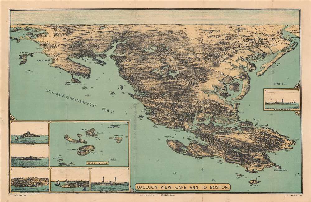
Balloon view - Cape Ann to Boston.
1879 (dated) 11.25 x 17.75 in (28.575 x 45.085 cm)
1879 (dated) 11.25 x 17.75 in (28.575 x 45.085 cm)
Description
A delightful 1879 bird's-eye view of Cape Ann and the North Shore of Massachusetts by Frank Kimball Rogers and John H. Daniels. While emphasizing Cape Ann's maritime significance, it also highlights important landward development, such as urbanization and railroad connections.
In the distance, Boston is depicted as nearly an island, the Shawmut Peninsula, only connected with the mainland by a narrow 'neck' of land to Dorchester and a milldam across a portion of the Charles River. In the years immediately following this view's publication, massive land reclamation projects would give the city its modern shape, greatly expanding South Boston, creating the Back Bay and Kenmore-Fenway, and filling in additional land in other parts of the city.
Another noteworthy feature is the prevalence of railroads, which developed into a dense network around New England by the mid-late 19th century. Many of these lines have been incorporated into the Massachusetts Bay Transportation Authority's Commuter Rail system, terminating at North Station in Boston.
A Closer Look
This view is oriented towards the southwest, with Gloucester and Rockport in the foreground and Salem, Lynn, Marblehead, Swampscott, Danvers, and Boston in the background. Seven insets appear around the main view: at right is the Plum Island Lighthouse off Newburyport, while at bottom-left are the Isles of Shoals along the maritime border of Maine and New Hampshire, Thacher (Thacher's) Island, Eastern Point Lighthouse in Gloucester, Norman's Woe Rock or Reef off the coast of Gloucester, Half-way Rock (not to be confused with another rock of the same name in Casco Bay, Maine) sitting halfway between Boston and Cape Ann, and Egg Rock (also known as Elephant Rock, not to be confused with the Egg Rock in Bar Harbor, Maine) in Nahant Bay.In the distance, Boston is depicted as nearly an island, the Shawmut Peninsula, only connected with the mainland by a narrow 'neck' of land to Dorchester and a milldam across a portion of the Charles River. In the years immediately following this view's publication, massive land reclamation projects would give the city its modern shape, greatly expanding South Boston, creating the Back Bay and Kenmore-Fenway, and filling in additional land in other parts of the city.
Another noteworthy feature is the prevalence of railroads, which developed into a dense network around New England by the mid-late 19th century. Many of these lines have been incorporated into the Massachusetts Bay Transportation Authority's Commuter Rail system, terminating at North Station in Boston.
Publication History and Census
This view was drawn by Frank Kimball Rogers and lithographed by John H. Daniels in 1879. It is listed in the OCLC among the holdings of the Boston Public Library, the New York Public Library, the Boston Athenaeum, and the University of Minnesota-Twin Cities. Scarce to the market.Cartographer
Frank Kimball Rogers (November 28, 1854 - November 23, 1930) was an American draftsman, artist, and viewmaker active in Cape Ann and Boston, Massachusetts. Rogers was born in Gloucester, the son of John Kimball Rogers, a type-founder, and great grandson of Daniel Rogers, one of Gloucester's founding citizens. Rogers is best known as a landscape painter who complete views of Cape Ann, Cape Cod, Gloucester, and Provincetown, among others. He died in Rhode Island and is buried at Oak Grove Cemetery, Essex. More by this mapmaker...
Condition
Good. Even toning. Wear along fold lines. Chips and small tears in margins. Verso repairs with archival tissue at left-center, top-right, and top-center margin. Offsetting along top mirroring the title cartouche at bottom. Accompanied by original cover, which has also been expertly repaired.
References
OCLC 961189268, 191908007.