This item has been sold, but you can get on the Waitlist to be notified if another example becomes available, or purchase a digital scan.
1750 Bellin Map of Macao Hong Kong China
Macao-bellin-1748$150.00

Title
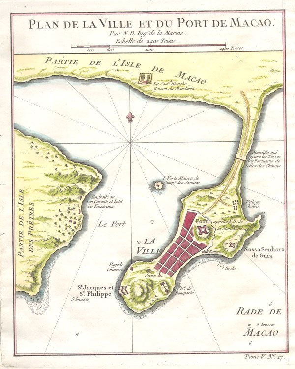
Plan de la Ville et du Port de Macao.
1784 (undated) 9 x 7 in (22.86 x 17.78 cm)
1784 (undated) 9 x 7 in (22.86 x 17.78 cm)
Description
This is a rare map of the city and port of Macao (Macau) dating to 1764 by Jacques N. Bellin. This map is one of the earliest depictions of Macao's street structure. Shows fortifications, roads, several important buildings, the fort, and a Chinese village near the Portuguese city. This map was issued as map number 17 in volume 5 of Abbe Prevost's Historie universale des voyages. Varients were also issued for Bellin's Petit Atlas Maritime and Nouvel Atlas de la Chine, de la Tartarie Chinoise.
Cartographer
Jacques-Nicolas Bellin (1703 - March 21, 1772) was one of the most important cartographers of the 18th century. With a career spanning some 50 years, Bellin is best understood as geographe de cabinet and transitional mapmaker spanning the gap between 18th and early-19th century cartographic styles. His long career as Hydrographer and Ingénieur Hydrographe at the French Dépôt des cartes et plans de la Marine resulted in hundreds of high quality nautical charts of practically everywhere in the world. A true child of the Enlightenment Era, Bellin's work focuses on function and accuracy tending in the process to be less decorative than the earlier 17th and 18th century cartographic work. Unlike many of his contemporaries, Bellin was always careful to cite his references and his scholarly corpus consists of over 1400 articles on geography prepared for Diderot's Encyclopedie. Bellin, despite his extraordinary success, may not have enjoyed his work, which is described as "long, unpleasant, and hard." In addition to numerous maps and charts published during his lifetime, many of Bellin's maps were updated (or not) and published posthumously. He was succeeded as Ingénieur Hydrographe by his student, also a prolific and influential cartographer, Rigobert Bonne. More by this mapmaker...
Condition
Very good condition. Blank on verso. Original platemark visible.
References
Library of Congress, G7823.M2 1764 .B38 TIL.