This item has been sold, but you can get on the Waitlist to be notified if another example becomes available, or purchase a digital scan.
1900 National Publishing Map of Massachusetts, Connecticut, Rhode Island
MACTRI-nationalpublishing-1900$150.00

Title
The National Publishing Company's Railroad, Post Office, Township and County Map of Massachusetts, Rhode Island and Connecticut.
1900 (dated) 35.5 x 38 in (90.17 x 96.52 cm) 1 : 316800
1900 (dated) 35.5 x 38 in (90.17 x 96.52 cm) 1 : 316800
Description
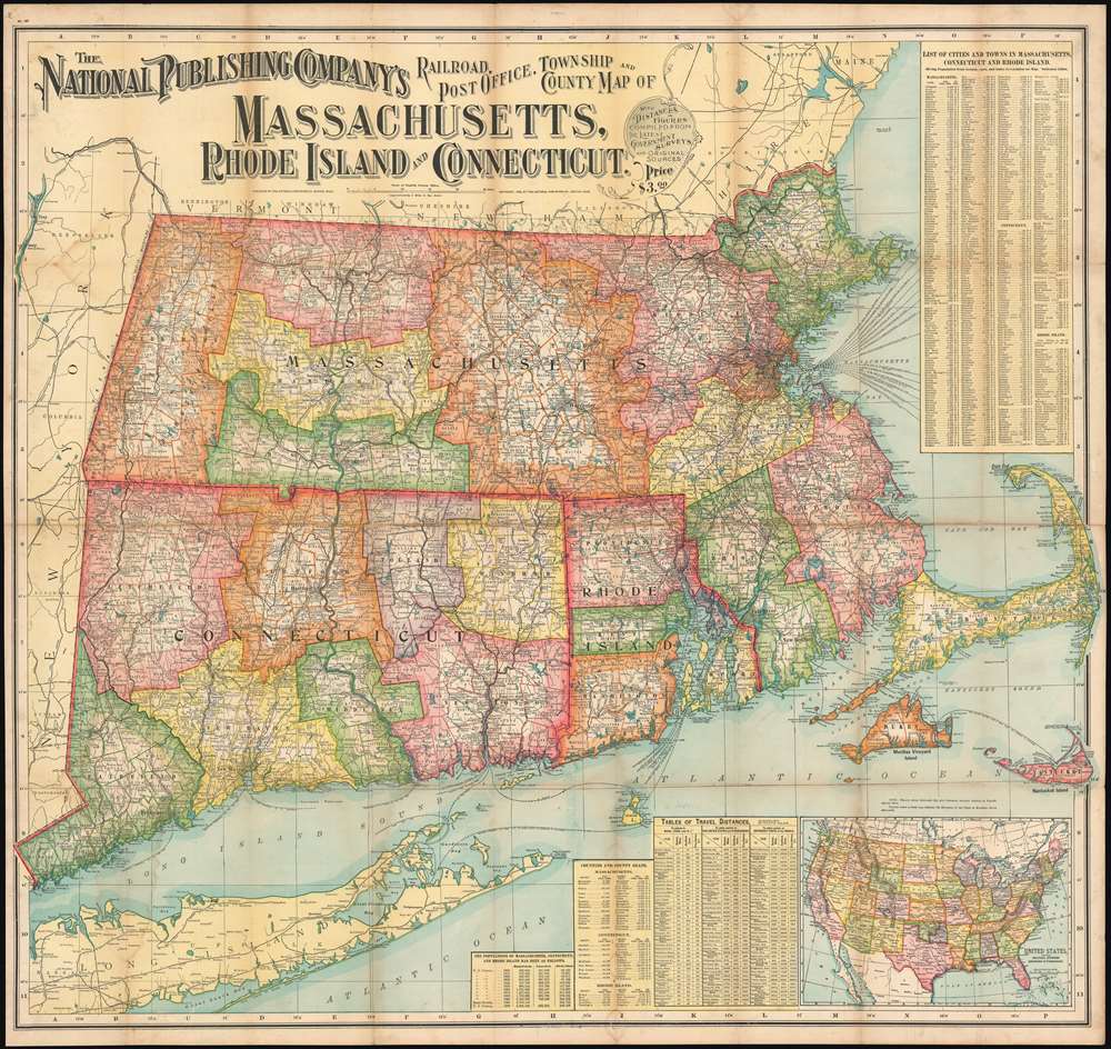
This is a 1900 National Publishing Company map of Massachusetts, Connecticut, and Rhode Island. The map depicts all three states in their entirety, along with parts of Long. Island, New Hampshire, Vermont, New York State, and Maine.
Railroads
With impressive detail, this map was intended to help travelers navigate the complex regional railroad, trolley, and coach system. Both major and minor railroads are illustrated, including the 'New York, New Haven, and Hartford Railroad' and the 'Boston and Maine Railroad'. At this point, eighty percent of cities and towns in these three states were served by rail.A Map Full of Details
Counties are outlined with various colors to allow for easy differentiation, and individual townships within the counties are identified. The most important cities noted, include Providence, Boston, Hartford, and New Haven, marked by large black type. Both Martha's Vineyard and Nantucket appear in detail in the lower right. A city and town index is included in the upper right corner, while travel distance tables, a list of counties and county seats, and an inset map of the entire United States appear in the bottom right.Publication History and Census
This map was created and published by the National Publishing Company in 1900 and is likely the first edition. This is the only known example of the 1900 edition. Later editions, copyrighted in 1902 and 1903, are cataloged in OCLC as being part of ten institutional collections.Cartographer
National Publishing Company (1897 - 1902) was an American map publishing firm founded in Portland, Maine in 1897. The founders, brothers Walter C. Scarborough (June 4, 1862 - May 9, 1904) and Howard G. Scarborough (December 23, 1867 - June 10, 1905), were also proprietors of the Scarborough Company and the Dominion Publishing Company. The National Publishing Company was intended to be managed by Howard, with Walter serving as treasurer. By 1901, the firm had relocated to Boston, where it published and sold large scale brilliantly printed road maps. In 1902, the Scarborough brothers merged their three concerns into the Boston based Scarborough Company and opened an office in Indianapolis, Indiana. Walter and Howard died in 1904 and 1905, both from tuberculous, but the Scarborough Company continued, transferring its offices to Indianapolis. In 1913 it became the Scarborough Motor Guide Company (c. 1913 - c. 1933). It does not appear to be related to the more prominent general publisher of the same name based out of Philadelphia. More by this mapmaker...
Condition
Very good. Mounted on linen. Exhibits light wear and toning along original fold lines. Areas of damp staining evident on verso that is minimally apparent on the map. Blank on verso.
References
OCLC 24205914 (1903).