This item has been sold, but you can get on the Waitlist to be notified if another example becomes available, or purchase a digital scan.
1895 French Military Invasion Map of Madagascar
Madagascar-beylie-1895$1,250.00


Title
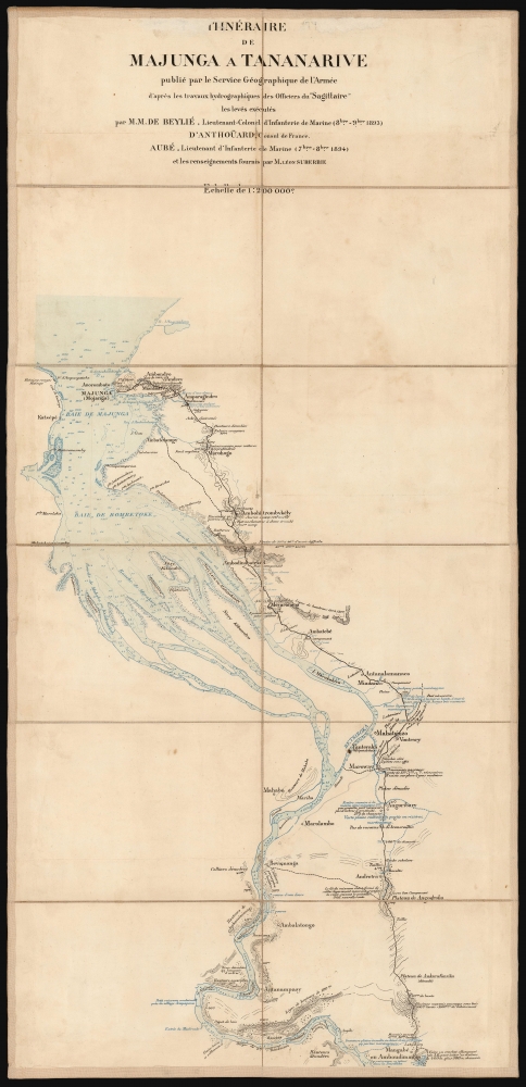
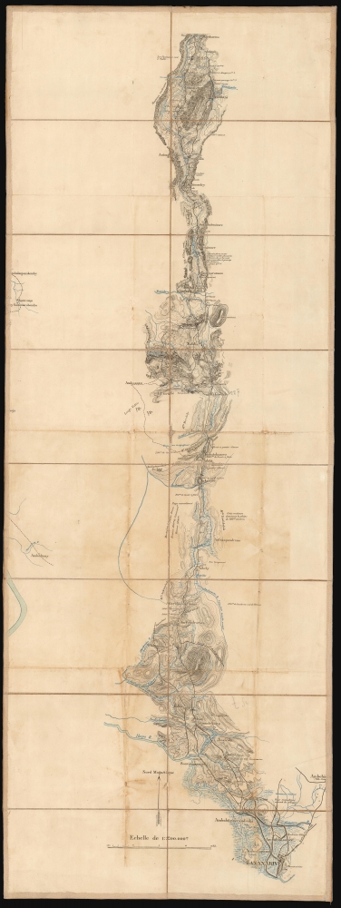
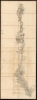
Itineraire de Majunga a Tananarive publie par le Service Geographique de l'Armée...
1895 (undated) 34 x 12.5 in (86.36 x 31.75 cm) 1 : 200000
1895 (undated) 34 x 12.5 in (86.36 x 31.75 cm) 1 : 200000
Description
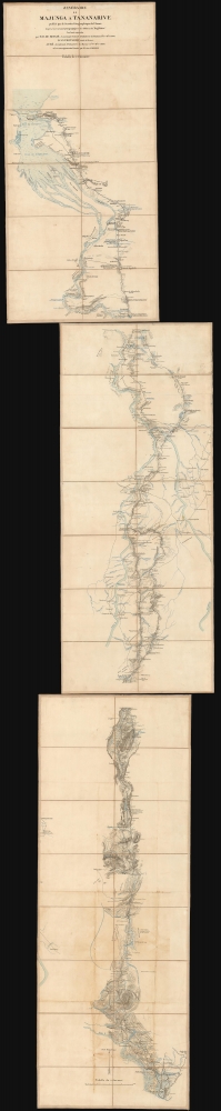
This detailed and rare trio of military folding maps of Madagascar follow a route connecting the northwest port of Mahajanga (Majunga) and the capital at Antananarivo (Tananarive). They were produced to record the campaign of the so-called 'Second Madagascar Expedition' (1894 - 1895), which brought the Franco-Hova Wars (1834 - 1896) to a close and turned Madagascar into a French protectorate.
Sources
There are several sources credited for the map's detail: the French marine officers Beylié and Aubé, the interim ambassador of 1894, Baron Albert François Ildefonse d' Anthoüard, and the adventurer, gold concessionaire, and amateur diplomat André Léon Suberbie. The printer is not named but may have been the lithographers Berger-Levrault et Cie in Nancy, who in 1897 produced a another map based on this content.The Second Madagascar Expedition
The refusal of Queen Ranavalona III of Madagascar's Merina dynasty to accept a protectorate treaty from France after the First Franco-Hova War (December 1883) resulted in a de-facto French declaration of war on the dynasty. An expeditionary corps under General Jacques Duchesne (1837 - 1918) captured Madagascar's harbors of Toamasina on the east coast, and Mahajanga on the west, in December 1894 and January 1895, respectively. The body of the force, some 15,000 soldiers, were landed in Mahajanga in May 1895. In order to advance, the French had to construct a road as they pushed into the interior against constant guerilla attacks, as well as inclement rainy-season tropical weather. Although only 25 French soldiers died from fighting (and thousands form disease), they did not reach the capital until the end of September. An artillery bombardment of the city led to a quick surrender. The island was made a French protectorate in 1895 and annexed in 1896.A Long-Planned Offensive
The map's military sources pre-date the December 1894 opening of hostilities: Belié's contribution is dated October and November 1893, and Aubé's is dated September and October 1894. Between these, and the writings of diplomat Anthoüard and the longtime Madagascar resident Suberbie, it appears clear that the basis of these charts were surveys made in advance of the French invasion, and that the invasion was likely planned well in advance of those surveys.On the Map
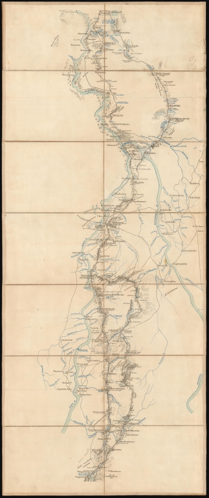
The focus of the work is detailed and direct. It is printed in two colors, with water elements marked in blue and other features in black. Mahajanga's harbor is well charted and replete with depth soundings. Strategic features are noted all along the prospective route, and include good areas for encampments, the presence of fortifications, and good and bad passages across rivers including places where bridges would be necessary. There are no indications of battles fought during the war in 1895. For example, the region of Andriba (where the French were stalled in August) appears as a mountain overlooking the prospective route, but there is no indication of the disease-wracked delay there. No mention of the bombardment or surrender of Tananarive appears, but the northernmost points from which the city can be seen are noted.More Firsthand Surveys
The observations of the officers Beylié and Aubé are supplemented by the earlier work of André Léon Suberbie, whose search for gold on the island had led to exploration from the French-held ports on the east coast to the capital at Tananarive, and from there to Majunga on the northern coast. Suberbie leased plantations around the country, and so he had a personal interest in the island's topography. Between the first and second parts of the war, Suberbie secured a gold concession from the Queen, for which he formed the Société des mines d'or de Suberbieville, capitalized at an astounding sixteen million Francs. The Société established a mining town (Suberbieville) on the Ikopa River just upstream from Mevatanana in northern Madagascar. (This is marked on the middle sheet of the map.) Between the years 1888 and 1894 the mine produced roughly 1250 kilograms of gold, underscoring its rich potential.Publication History and Census
This map is extremely rare. We see no other examples of it in dealers' listings or institutional collections. An 1897 map published by Lith. Berger-Levrault et Cie (Nancy), Itinéraire de Majunga à Maharidaza : 2me feuille was copied from part of this one; a single example of it appears in the Bibliothèque Nationale de France. No market history.CartographerS
Léon Marie Eugène de Beylié (1849-1910) was a French colonial military officer, archaeologist, and art collector. He graduated from Saint-Cyr Military Academy, and subsequently served in military campaigns in North Africa, Central Asia, Madagascar, and Cochinchina. During the course of his military travels, he sent back to France some two thousand pieces of furniture, weapons, statues, and works of art, all donated to the Museum-Library of Grenoble. To his credit, he took extensive notes during these archeological acquisitions. To his military postings, he added on his own account journeys to Burma, China, Japan, and Java. His travels took him as far as the ruins at Angkor, which few Europeans at that point had laid eyes on. Near the end of his life he published a study of Hindu architecture in the Far East. When he died by drowning in the Mekong in 1910, he had reached the rank of General. More by this mapmaker...
Henri François Adolphe Auguste Aubé (February 10, 1865 - December 3 1935) was a French soldier and legionnaire. He was born to French parents in Bahia, Brazil, and would be educated at Saint-Cyr Military Academy. He received a commission as a Second Lieutenant of Marine Infantry on October 1, 1887, and was promoted to Lieutenant in 1891. His service took him to Cherbourg in 1892 and Benin in 1894. He was promoted to Captain in 1895, by which time he had been in service in Madagascar during the Second Expedition. He was still posted there in 1896. From 1897 to 1900 he would serve in the 1st Marine Infantry Regiment. In the First World War he was Colonel commanding the 21st Marine Infantry Regiment, and was made an officer of the Legion of Honor. He became Commander of the Legion of Honor on December 28, 1921, being Brigadier General, Member of the Advisory Committee for the Defense of the Colonies. Learn More...
André Léon Suberbie (July 3, 1854 - October 30, 1907) was a French adventurer, colonial and gold concessionaire, whose exploits in Madagascar would win him entrance to the Legion of Honour. He was the founder of Société des mines d'or de Suberbieville, a gold mining concession in north central Madagascar about which he would build a town bearing his name. He would go on to publish, with Edouard Laillet, the first modern survey of the island in 1889.
His early life is obscure. Born in Toulouse, he advanced swiftly from employment on the southern railways, to becoming commissioner on a ship of the Paquet company; in 1874 he gained employment in Madagascar by the Marseille trading house Roux de Fraissinet (the same company which would set up his brother-in-law and collaborator Edouard Laillet in that country). Suberbie spent several years in Mahanoro, then in Tamatave. By 1880 he was in charge of the company office in Tananarive, where he made a great impression with his commercial abilities as well as his command of the Malagasy language: in his correspondence he was on intimate terms with both the Merina Prime Minister and Queen, calling them 'Cher Ami' and 'Majesté et chère amie' respectively. From the Prime Minister's son, he was able to lease plantations for coffee, cotton, cocoa, sugar cane and raffia. As diplomatic relations between France and the Merina regime deteriorated, official French representatives abandoned Tananarive in fear of their lives, leaving Suberbie and his compatriots the closest thing to official representation left to France in the capital. He was active in this role, successfully foiling British attempts to gain influence with the Merina. His influence allowed him to extend protection to many of his fellow colonials: During the 1882-85 Franco-Merina War he led a 23-day march from Tananarive to Tamatave of 92 French men, women and children following their expulsion from the former city by the Hovas. (This exploit would win Suberbie the Legion of Honor; though according to reports of the event, the march was not so much led by Suberbie as it was by a troop of Hovas, who turned the French loose at Ivondoro, just south of Tamatave.) He was active in more areas than the political: by 1883 he had become one of the few Europeans to explore from coastal Madagascar to the interior at Tananarive; from Tananarive to Majunga; and from there, down the west coast to Cap. St. Vincent. Suberbie in 1885 was able to establish the Société des mines d'or de Suberbieville, a company capitalized at sixteen million Francs, to mine gold at a site southwest of Maevatanana along the Ikoka River. He was the first European to be granted a concession to do so by Imperial Merina - no doubt another facet of his warm personal relations with the regime. Between the years 1888 and 1894 the mine would produce nearly 1250 kilograms of gold. Ironiclly, During the 1895 campaign, which culminated in the 1896 French absorption of Madagascar as a colony, Suberbieville would provide the main supply and concentration center for French troops. Suburbie's company does not seem to have survived the fall of Merina for long, and with the annexation of Madagascar Suberbie's political influence seems to have disappeared. Neither seem to have survived better than did Suberbie himself, who died in Toulouse in 1907.
Learn More...
Albert François Ildephonse Anthouard de Wasservas (October 12, 1861 - October 10, 1944) was a French diplomat, historian and author. The son of brigadier general Charles Alexandre Comte d'Anthouard and a superb student, he would join the administration of Cochinchina in 1881; as Secretary at the Department of the Interior, he was sent to Saigon (1882) and then Bien Hoa where he explored the Moï country. He returned to Saigon and would remain there throughout the conquest of Indochina. He was then seconded to the General Residence of Tananarive in Madagascar, as secretary to Mr. le Myre de Vilers, then successively and for eight years, as vice-president, president, and delegate to the General Residence. He would later be posted to Montenegro, and Beijing, where he was posted during the Boxer Rebellion. He participated in the march to relieve the legations in Beijing on August 17, 1900). He would afterwards see postings in Tunis and Rio de Janeiro. Anthouard authored books and articles on the economy and politics in Brazil, Egypt, and on diplomacy in the colonies, including an 1895 communique with respect to the colonization of Madagascar. During the First World War, he assumed the presidency of the National Federation of Assistance Societies for Prisoners of War. He retired in 1918 to serve as general secretary of the Union of Women of France. He was in the 1920s General councilor of Haute-Loire, and was elected mayor of Lavoute Chillac. He was a founding member of the Academy of Colonial Sciences in 1922, and was successively knight, officer, and commander of the Legion of Honor (1913). He was elected full member of the 5th section of the Academy of Colonial Sciences upon its foundation in 1923, and was member of the Malagasy Academy. Learn More...
Condition
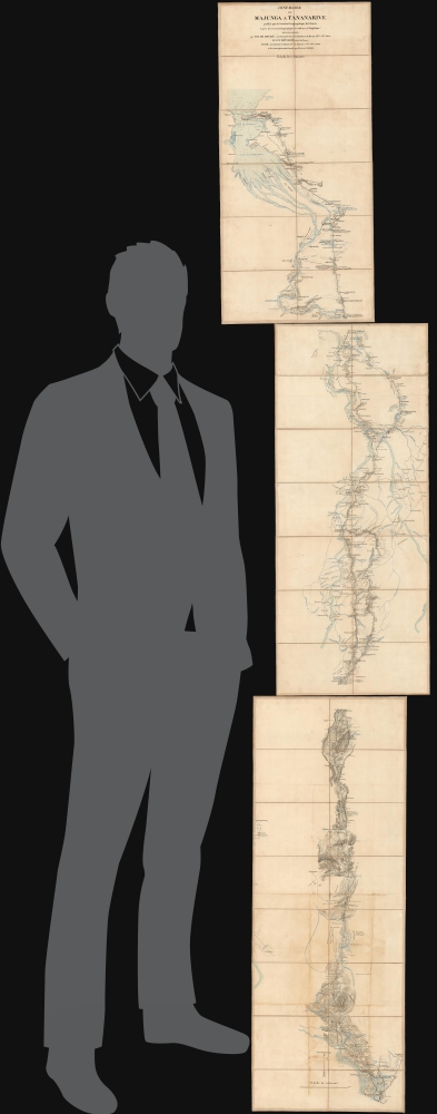
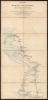
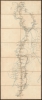
Very good. Three lithographed sheets, dissected and mounted on linen for folding. Few areas of wear at folds with very slight loss. Else excellent. Size given for bottom sheet. Each sheet is 12.5 inches wide by 26.25, 30.5 and 34 inches high respectively.
References
No copies in institutional collections.