This item has been sold, but you can get on the Waitlist to be notified if another example becomes available, or purchase a digital scan.
1697 Coronelli Map of Madagascar and part of Southern Africa
Madagascar-coronelli-1697-2$700.00


Title
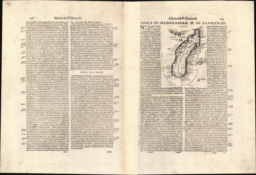
Isola di Madagascar, o di S. Lorenzo scoperta da Portoghesi nell'Anno 1506, Descritta dal P. Mrō Coronelli M.C. Cosmografo della Seren.ma Rep: Di Venetia, Dedicata All' Ill.mo Sigr. Antonio Magliabecchi, Bibliotecario dell' A. Serenissima Del Gran Duca di Toscana.
1697 (undated) 23.75 x 18 in (60.325 x 45.72 cm) 1 : 1011588
1697 (undated) 23.75 x 18 in (60.325 x 45.72 cm) 1 : 1011588
Description
This is Vincenzo Maria Coronelli's 1697 map of Madagascar, the most sophisticated 17th century map of the island. While the southeastern portion of the island reflects the cartography of Étienne de Flacourt (1607 - 1660), who from 1648 to 1653 was French East India’s Governor of Madagascar, and who in 1658 published the first natural history of the island, this map includes detail beyond any of the French or Dutch maps sourced from Flacourt's manuscripts. Typical of Coronelli's meticulously researched work, the map provides a granular catalogue of the island's coastline toponymy. The interior has been broken into administrative regions, including tribal names not present on any earlier printed maps.
It is notable that an indigenous name for the island appears here on the map. Isle St. Marie's Malagasy name is Nosy Boraha. Some sources associate the name 'Boraha' with a local Jonah-esque whale legend, but more frequently the name is translated to 'The Island of Abraham.' The origin of the name is obscure, but the name appearing on the map, Nossi Hibrahin, tends to reinforce not only the association with Abraham, but the notion that the name was first applied to the island by Arabic traders, whom the Portuguese had taken pains to drive from the island, partly for reasons of religion and partly to remove competition in trade.
Isle St. Marie
Just off the east coast of Madagascar lies the Isle St. Marie, also named Nossi Hibrahin and Isle d' Abraham on the map. First named Santa Maria by the Portuguese, it was the site of several failed attempts at settlement by the French and the English in the 1640s. This state of affairs would not last: by the time this map was produced, Isle St. Marie would become an infamous haven for English and French pirates preying on the ships passing to and from India. This map includes three settlements, including S. Marguerite.It is notable that an indigenous name for the island appears here on the map. Isle St. Marie's Malagasy name is Nosy Boraha. Some sources associate the name 'Boraha' with a local Jonah-esque whale legend, but more frequently the name is translated to 'The Island of Abraham.' The origin of the name is obscure, but the name appearing on the map, Nossi Hibrahin, tends to reinforce not only the association with Abraham, but the notion that the name was first applied to the island by Arabic traders, whom the Portuguese had taken pains to drive from the island, partly for reasons of religion and partly to remove competition in trade.
La Réunion
To the east of Madagascar appears I. De Bourbon, also named Mascaregne, and now known as La Réunion. This island is shown on maps of Africa going back into the 16th century. It was first named by Europeans as Santa Apollonia, a name given by the Portuguese, who visited the island in the first decade of the 16th century. No attempt to settle was made then, but in 1638 the French claimed it, officially occupying it in 1642 (by marooning a dozen mutineers there.) The French changedd the name to Île Bourbon in 1649, in honor of the French royal house. While the shape of the island is only approximate, its volcanic nature is revealed with the name Paese Incendiato. The island possesses one of the world's most active volcanoes, whose hundreds of recorded eruptions go back to the 17th century. The French East India Company would not seriously attempt colonization of Île Bourbon until 1665, two years before the publication of this map. The wealth of place names on the coast of the island here - much more than appear on earlier French maps of the region - suggests that Coronelli's source may have been positioned in or near the French East India Company.A Remarkable Dedicatee
The curious reader is encouraged to search out an image of the bust, crafted by the artist Antonio Montaiuti, or Antonio di Marco Magliabecchi - the dedicatee of this map. The artist appears to have captured the spirit of this Florentine librarian, a formidable scholar and bibliophile as dedicated to learning as he was NOT to the tidiness of his clothes and the maintenance of his personal relationships. Among bibliophiles he was truly a giant, in that he was reputed to have actually read all the books he bought. And he bought many: his library consisted of forty thousand books and ten thousand manuscripts. He so valued his time reading that he would not take time to change clothes or even undress for bed. This eccentric figure was, despite the obvious visceral challenges of associating with him, sought out by scholars from all over Europe for the depth and breadth of his knowledge, and it is plain that Coronelli valued his assistance greatly enough to dedicate this map to him.Publication History and Census
There are only three examples of the separate map listed in OCLC: Harvard, the Bibliotheque National, and the Bayerische Staatsbibliothek. Coronelli's Atlante veneto is, however, well represented in institutional collections.Cartographer
Vincenzo Maria Coronelli (August 16, 1650 - December 9, 1718) was an important 17th-century cartographer and globe maker based in Venice. Coronelli was born the fifth child of a Venetian tailor. Unlikely to inherit his father's business, he instead apprenticed in Ravenna to a woodcut artist. Around 1663, Coronelli joined the Franciscan Order and, in 1671, entered the Venetian convent of Saint Maria Gloriosa dei Frari. Coronelli excelled in the fields of cosmography, mathematics, and geography. Although his works include the phenomenal Atlante Veneto and Corso Geografico, Coronelli is best known for his globes. In 1678, Coronelli was commissioned to make his first major globes by Ranuccio II Farnese, Duke of Parma. Each superbly engraved globe was five feet in diameter. Louis IV of France, having heard of the magnificent Parma globes, invited Coronelli to Paris, where from 1681-83 he constructed an even more impressive pair of globes measuring over 12 feet in diameter and weighing 2 tons each. The globes earned him the patronage of Louis XIV and privileged access to French cartographic information from Jesuit sources in the New World, particularly Louisiana. Coronelli returned to Venice and continued to publish globes, maps, and atlases, which were admired all over Europe for their beauty, accuracy, and detail. He had a particular fascination for the Great Lakes region, and his early maps of this area were unsurpassed in accuracy for nearly 100 years after their initial publication. He is also well known for his groundbreaking publication of the first accurate map depicting the sources of the Blue Nile. At the height of his career, Coronelli founded the world's first geographical society, the Accademia Cosmografica degli Argonauti, and was awarded the official title Cosmographer of the Republic of Venice. In 1699, in recognition of his extraordinary accomplishment and scholarship, Coronelli was also appointed Father General of the Franciscan Order. The great cartographer and globe maker died in Venice at the age of 68. His extraordinary globes can be seen today at the Bibliothèque Nationale François Mitterrand in Paris, Biblioteca Marciana in Venice, the National Library of Austria, the Globe Museum in Vienna, the Library of Stift Melk, the Special Collections Library of Texas Tech University, as well as lesser works in Trier, Prague, London, and Washington D.C. Coronelli's work is notable for its distinctive style, which is characterized by the high-quality white paper, dark intense impressions, detailed renderings of topographical features in profile, and numerous cartographic innovations. More by this mapmaker...
Source
Coronelli, V., Atlante Veneto, (Venice: Girolamo Albrizzi) 1697.
The Atlante Veneto was a Venetian cosmographic atlas issued by the Jesuit Minorite friar, geographer, and globe maker Vincenzo Maria Coronelli. The massive work consists of some 13 volumes in four parts. The first section focused on a general introduction to geography and included notes on various geographic systems and globes. The second part consisted of world maps from various periods and in various styles, including double-page maps of the continents and poles derived from his earlier globe work. The third part focused on hydrography and included nautically styled maps of important rivers, bays, oceans, lakes, and gulfs. The fourth and final section details exploration. The whole consisted of some 191 engraved charts and maps as well as an assortment of views and decorative plates. The atlas was conceived as a continuation of Blaeu's Atlas Major and, in many respects, follows Blaeu cartographically. Many of the other maps are derived from Coronelli's own earlier globe work and exhibit distinctly globe-like elements. Coronelli first issued the Atlante Veneto in 1691. A second edition was prepared and issued between 1695 and 1697. Most of the individual map plates remain identical and thus indistinguishable between editions. The maps of the Atlante Veneto are universally admired for their exquisite engraving and high production quality, including fine paper and premium inks. All examples were issued uncolored and have typically been left as such by dealers and collectors. Some of Coronelli's other works, including the Isolario dell' Atlante Veneto, Libro dei Globi, and Corso Geografico Universal, might reasonably considered amendments and expansions on the Atlante Veneto.
Condition
Very good. Generous margins. Some text show through, else excellent.
References
Rumsey 11391.096. OCLC 714043656.