This item has been sold, but you can get on the Waitlist to be notified if another example becomes available, or purchase a digital scan.
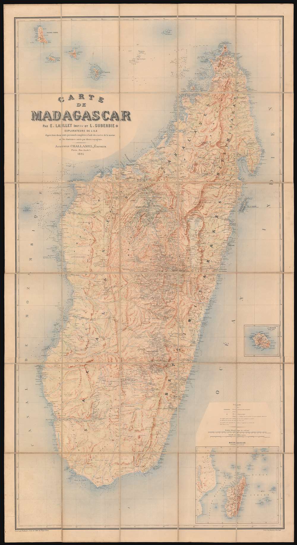
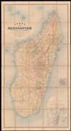
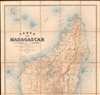
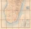
1895 Laillet and Suberbie Map of Madagascar
Madagascar-lailletsuberbie-1895$2,750.00

Title
Carte de Madagascar.
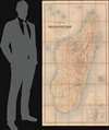
1895 (dated) 74 x 40 in (187.96 x 101.6 cm) 1 : 1000000
1895 (dated) 74 x 40 in (187.96 x 101.6 cm) 1 : 1000000
Description
This large, magnificently detailed, and rare map of Madagascar is the first modern, scientific survey of the island. This map is significant not only for its groundbreaking cartography, but also for its support of insights into the complex and often conflicting loyalties and motivations that unpinned colonial life: loyalties to self, to company, to countryman, to nation, and to the adopted nation.
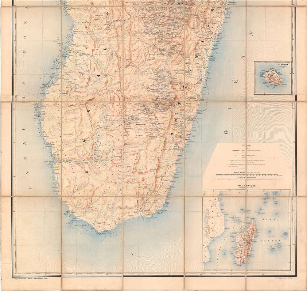
France won the war, and the subsequent treaty levied a huge indemnity against Madagascar. To pay it (and to raise funds for arms), the Merina reversed their policy on gold mining, offering concessions to foreign companies to establish mines on behalf of the Queen. André Léon Suberbie was the first such concessionaire, for which he formed the Société des mines d'or de Suberbieville, capitalized at an astounding sixteen million Francs. The Société established a mining town (Suberbieville) on the Ikopa River just upstream from Mevatanana in northern Madagascar. Between the years 1888 and 1894 the mine produced roughly 1250 kilograms of gold, underscoring its rich potential. Even so, from the point of view of Madagascar, the scheme failed as much of the island's gold was smuggled to English and French traders and did little to pay the war debt.
Laillet and Suberbie
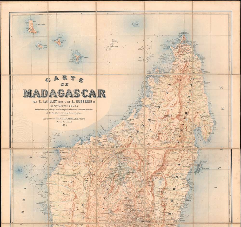
First published in 1889, it was produced around 1884 by French civil engineer Édouard Laillet and his brother-in-law, the adventurer, gold concessionaire, and amateur diplomat André Léon Suberbie. Both were assigned to Madagascar by the Marseille trading house 'Roux de Fraissinet', and as such were in a unique position to survey both the coasts and interior, as well as to capitalize as first-movers in the pre-colonial space. Posted in the capital of Tananarive, Suberbie became an intimate of both Madagascar's Queen Ranavalona III (1861 - 1917) and Prime Minister Rainilaiarivony (1828 - 1896), placing him in a position of unparalleled access during the period of political intrigue leading up to the 1896 French annexation of Madagascar.Firsthand Surveys
Laillet previously published, in 1877, surveys of Madagascar's east coast harbors and anchorages; all evidenced here. Suberbie's explorations from the French-held ports on the east coast reached the capital at Tananarive (Antananarivo), from Tananarive to Majunga on the northern coast; and down the west coast to Cape St. Vincent. Suberbie, leveraging his Malagasy political connections, leased plantations and in the country, thus spurring a personal interest in the island's topography.Gold and Colonial Maneuvering in Madagascar
Reaching back to the 16th century, Madagascar was reputed to be burgeoning with gold, and indeed by the mid-19h century, deposits proved plentiful. Madagascar's Imperial regime, the Merina, were aware of the wealth, but deliberately suppressed knowledge of it, even punishing Malagasy who illicitly mined. Thus, they hoped to avoid the notice of greedy colonial powers. It worked up to a point, but France nonetheless maintained a toehold in Madagascar as a staging point to counter British India. This led to numerous conflicts between French civilian and military officials, and the Malagasy, culminating in the 1883 French invasion of Madagascar, better known as the First Franco-Hova War (1883 - 1885). Over the course of the war, Suberbie successfully leveraged his influence with the Merina to protect his fellow colonists. These efforts saw him knighted as Chevalier de la Légion d'Honneur (note the medal following his printed name). It was during this war that Laillet and Suberbie compiled this map, and despite Suberbie's continuous efforts to achieve common ground between the French invaders and the Malagasy, its military utility is clear.France won the war, and the subsequent treaty levied a huge indemnity against Madagascar. To pay it (and to raise funds for arms), the Merina reversed their policy on gold mining, offering concessions to foreign companies to establish mines on behalf of the Queen. André Léon Suberbie was the first such concessionaire, for which he formed the Société des mines d'or de Suberbieville, capitalized at an astounding sixteen million Francs. The Société established a mining town (Suberbieville) on the Ikopa River just upstream from Mevatanana in northern Madagascar. Between the years 1888 and 1894 the mine produced roughly 1250 kilograms of gold, underscoring its rich potential. Even so, from the point of view of Madagascar, the scheme failed as much of the island's gold was smuggled to English and French traders and did little to pay the war debt.
A British Gambit
Just as the 1889 first edition of this map was produced during the First Franco-Hova War, this second edition was produced during the Second Franco-Hova War (1894 - 1895). In a 'Scramble for Africa' gambit, the British recognized the France Protectorate over Madagascar in return for uncontested British control of Zanzibar. (From the British point of view, the strategic importance of Madagascar waned following the opening of the Suez Canal.) Meanwhile, hoping to drive out the French and defend against further colonial incursions, Prime Minister Rainilaiarivony (1828 - 1896) made a large arms purchase in Europe. In 1894, fearful of a potential revolt, France sent a preemptive strike force to Madagascar, taking Antananarivo in 1895 - this was the Second Franco-Hova War (1894 - 1895). In the aftermath, Queen Ranavalona III was exiled to Réunion and later French Algeria.Suburbie's Fall from Grace
Despite a dramatic falling out with Prime Minister Rainilaiarivony, the French suspected Suberbie of being an agent of the Merina. Distrusted by both sides, and his economic interests in shambles, Suberbie returned to his hometown of Toulouse, where he died in 1907. The company town of Suberbieville diminished to a near ghost-town, although Google Earth reveals an unnamed settlement persisting at the location.An Eminently Useful Map
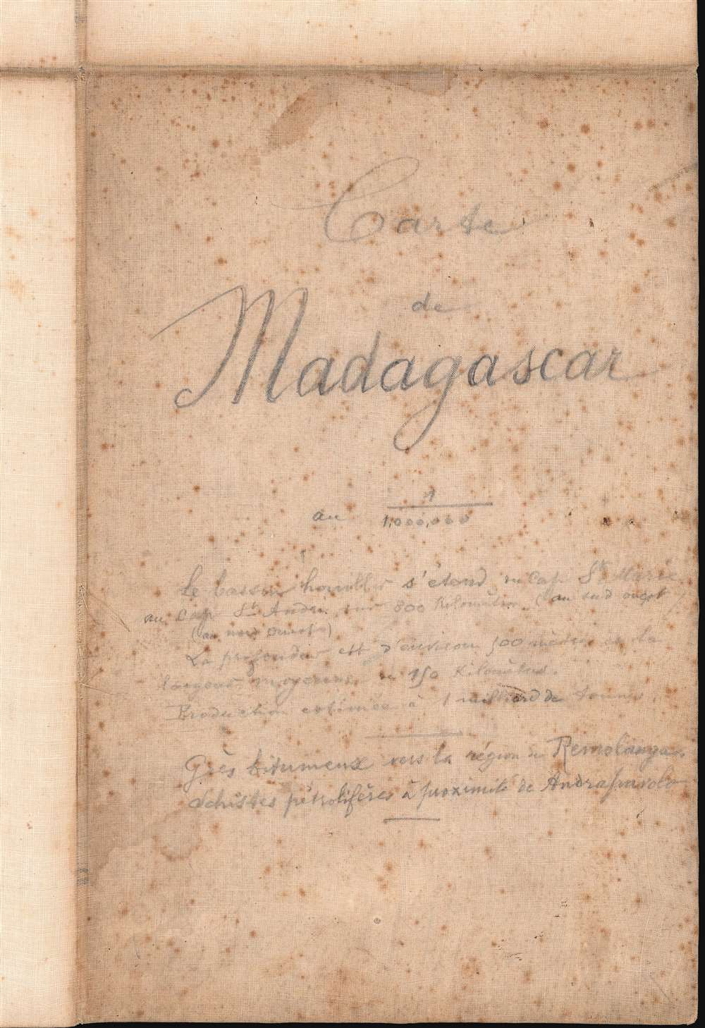
Laillet and Suberbie's map is a cartographic masterpiece, with matchless detail and effective depiction of topography. Its production doubtless informed Suberbie in his selection of a site for his gold concession and plantations. As the finest map of the Madagascar obtainable, the map had persistent value, and was consulted for military, political, and resource research for decades to follow. A case in point, on the back of this map, extensive pencil annotations discusses the location, length and depth of a Madagascar coal field, as well as notes on discoveries of bitumen and petroliferous shale.Publication History and Census
This map is very rare. It was published by the Paris publisher and hack historian Augustin Challamel, first in 1889 and again in 1895. OCLC lists only 2 copies of this 1895, in the Bibliotheque Nationale and at Harvard; the 1889 edition appears in three collections: the British Library, the Bibliotheque Nationale de France, and the Biblioteca Nacional de Espana. No market history.CartographerS
Édouard Laillet (March 20 , 1853 - December 26, 1927) was a French civil engineer, cartographer and writer. He was born to an affluent family; his father was a successful notary. He received a bachelor's degree in 1870 just in time to be taken captive in the defense of Épinal during the Franco-Prussian war, but was able to escape to Lyon. He resumed his education in 1873 at the École centrale des arts et manufactures de Paris, graduating as an engineer in 1876 - part of his education included an 1875 circumnavigation via sailing ship which he undertook as work study. He was hired by the shipping company Roux et Fraissinet and sent to Madagascar tasked to install a rice husking factory in Manahoro on the west coast. He did not limit his activities to this: he would produce a chart for the French government of potential anchorages on the east coast of the island, about which he would publish in 1877. He was a founder of Syndicat de la Presse Coloniale Française and the Society of French colonists in Madagascar, an aid society for to French colonists in difficulty. His intimate familiarity with the island's geography was put to French use during the 1883-1895 Franco-Malagasy war. In partnership with his brother-in-law Léon Suberbie (founder of the Société des mines d'or de Suberbieville he produced, in 1884, the first modern survey of the island. This was first published in 1889. In addition to his geographic achievements, he and his colleague Paul Leprince established a coffee roasting plant in France, increasing the purity of the roasted coffee and earning the pair awards at World's Fairs in Paris, Brussels and London. More by this mapmaker...
André Léon Suberbie (July 3, 1854 - October 30, 1907) was a French adventurer, colonial and gold concessionaire, whose exploits in Madagascar would win him entrance to the Legion of Honour. He was the founder of Société des mines d'or de Suberbieville, a gold mining concession in north central Madagascar about which he would build a town bearing his name. He would go on to publish, with Edouard Laillet, the first modern survey of the island in 1889.
His early life is obscure. Born in Toulouse, he advanced swiftly from employment on the southern railways, to becoming commissioner on a ship of the Paquet company; in 1874 he gained employment in Madagascar by the Marseille trading house Roux de Fraissinet (the same company which would set up his brother-in-law and collaborator Edouard Laillet in that country). Suberbie spent several years in Mahanoro, then in Tamatave. By 1880 he was in charge of the company office in Tananarive, where he made a great impression with his commercial abilities as well as his command of the Malagasy language: in his correspondence he was on intimate terms with both the Merina Prime Minister and Queen, calling them 'Cher Ami' and 'Majesté et chère amie' respectively. From the Prime Minister's son, he was able to lease plantations for coffee, cotton, cocoa, sugar cane and raffia. As diplomatic relations between France and the Merina regime deteriorated, official French representatives abandoned Tananarive in fear of their lives, leaving Suberbie and his compatriots the closest thing to official representation left to France in the capital. He was active in this role, successfully foiling British attempts to gain influence with the Merina. His influence allowed him to extend protection to many of his fellow colonials: During the 1882-85 Franco-Merina War he led a 23-day march from Tananarive to Tamatave of 92 French men, women and children following their expulsion from the former city by the Hovas. (This exploit would win Suberbie the Legion of Honor; though according to reports of the event, the march was not so much led by Suberbie as it was by a troop of Hovas, who turned the French loose at Ivondoro, just south of Tamatave.) He was active in more areas than the political: by 1883 he had become one of the few Europeans to explore from coastal Madagascar to the interior at Tananarive; from Tananarive to Majunga; and from there, down the west coast to Cap. St. Vincent. Suberbie in 1885 was able to establish the Société des mines d'or de Suberbieville, a company capitalized at sixteen million Francs, to mine gold at a site southwest of Maevatanana along the Ikoka River. He was the first European to be granted a concession to do so by Imperial Merina - no doubt another facet of his warm personal relations with the regime. Between the years 1888 and 1894 the mine would produce nearly 1250 kilograms of gold. Ironiclly, During the 1895 campaign, which culminated in the 1896 French absorption of Madagascar as a colony, Suberbieville would provide the main supply and concentration center for French troops. Suburbie's company does not seem to have survived the fall of Merina for long, and with the annexation of Madagascar Suberbie's political influence seems to have disappeared. Neither seem to have survived better than did Suberbie himself, who died in Toulouse in 1907.
Learn More...
Jean Baptiste Marius Augustin Challamel (March 18, 1818 - October 20, 1894) was a French historian, editor, and publisher active in Paris in the mid to late 19th century. Challamel is best known as a historian. Even so, although prolific, his personal work more often falls into pop-history and has little originality or merit. More significantly, Challamel also founded Challamel et Cie., a publishing house at 5 Rue Jacob. From this location, Challamel published extensively for French colonial interests in Africa, Asia, Indochina, and Polynesia. His work includes some of the most significant works documenting late 19th century French scientific discoveries, navigation, cartography, and scholarship. He held the contract for official French colonial office printings, including for the Bureau Topographique and the Service Geographique. Although Challamel died in 1894, his firm continued to operate until the 1920s. His heirs, operating under the same name, moved tore 17 Rue Jacob and renamed their firm Librairie Maritime et Coloniale, Augustin Challamel, Editeur. Learn More...
Jean Noël Monrocq (December 25, 1819 - February 18, 1913) was a French printer and bookseller active in Paris in the mid to late 19th century. Monrocq was born on Chrismtas day, hence his name, in Trelly, La Manche, the son of a farmer. In 1839 he moved to Paris for a more urban lifestyle. Although he had little formal education, he found work with the Parisian book and print seller Delarue. Meating some success, he opened his own print shop in 1848. He initially applied for a booksellers patent in 1853, but the application was initially rejected. It was formally approved in 1877. In 1859, he received a lithographers patent for artistic and industrial prints for education purposes. He took over the presses of Louis Etienne Stanislas Petit in 1859, but did not relieve a formal intaglio imprint until 1865. In March 1874, he established a branch of his lithographic printing press in Ivry, Rue de Vitry, where he moved part of his equipment. He became known for zincographic lithography - the process of etching plates into zinc, which he claimed falsely to have invented. He did nonetheless, contributed significantly to the industrialization of the printing with zinc plates. Being cheap, simple to make, easy to modify, zinc plates became the standard for news printing. Zincography under Monrocq was also ideally suited to map production. The Monrocq produced a significant corpus of maps. The firm spearheaded the movement to centralize map production in France. The firm continued well after his death, issuing maps for both Hachette Taride. For a long time, his son, Léon Monrocq (1857 - 1902) worked with him specifically printing maps, unfortunately he died young. The firm for a time was operated by the founder's son-in-law, who took the name Gaillac-Monrocq. Jean Noël Monrocq's grandson Lucien Monrocq, eventually took over the publishing arm of the firm. Learn More...
Condition
Very good. Dissected and laid on original linen. Some manuscript notes on verso.
References
OCLC 494951918.