This item has been sold, but you can get on the Waitlist to be notified if another example becomes available, or purchase a digital scan.
1846 Bradford Map of Maine
Maine-bradford-1846$112.50

Title
Maine.
1846 (dated) 15 x 12 in (38.1 x 30.48 cm) 1 : 1584000
1846 (dated) 15 x 12 in (38.1 x 30.48 cm) 1 : 1584000
Description
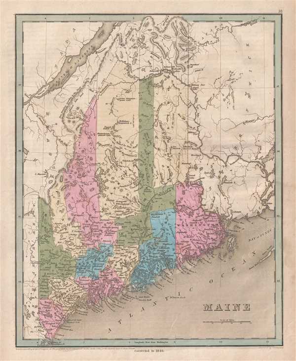
This is an 1846 Thomas G. Bradford map of Maine. The map depicts the region from Quebec (Lower Canada) and New York to New Brunswick and from Canada to the Atlantic Ocean. The most intriguing element illustrated here reflects the changes to the border between Maine and British Canada established by the Webster-Ashburton Treaty
The Aroostook War and the Webster-Ashburton Treaty
The Webster-Ashburton Treaty, which ended the Aroostook War (also known as the Pork and Beans War), and fixed the border between the United States and British Canada. A dispute over 13,000 square miles of land between modern-day Quebec and New Brunswick, erupted mostly due to disputes over logging rights in the region. This war, between British colonies in Canada, and American forces in the state of Maine, really should be called an international incident. No one was killed, two Canadian militiamen were injured, and several British were taken prisoner, but there was never a significant engagement between the two sides. The treaty, signed by U.S. Secretary of State Daniel Webster and British diplomat Alexander Baring, 1st Baron Ashburton in August 1842, gave the United States over half of the disputed territory. Here, Bradford illustrates both the newly agreed-upon border, along with the 'true border according to the Treaty of 1783'. The phrase 'true border' lends itself to the presumption that Bradford was unhappy with the treaty, like many of his countrymen.
Highly detailed, each county is labeled and color coded for easy differentiation. Numerous cities and towns are labeled, along with rivers and lakes. The railroad from Kittery to Portland is also illustrated.
This map was engraved by George Boynton and published in the 1846 edition of Bradford and Goodrich's A Universal Illustrated Atlas.
CartographerS
Thomas Gamaliel Bradford (1802 - 1887) was born in Boston, Massachusetts, where he worked as an assistant editor for the Encyclopedia Americana. Bradford's first major cartographic work was his revision and subsequent republishing of an important French geography by Adrian Balbi, Abrege de Geographie published in America as Atlas Designed to Illustrate the Abridgment of Universal Geography, Modern and Ancient. Afterwards Bradford revised and expanded this work into his own important contributions to American cartography, the 1838 An Illustrated Atlas Geographical, Statistical and Historical of the United States and Adjacent Countries. Bradford's cartographic work is significant as among the first to record Texas as an independent nation. In his long career as a map publisher Bradford worked with William Davis Ticknor of Boston, Freeman Hunt of New York, Charles De Silver of Philadelphia, John Hinton, George Washington Boynton, and others. We have been able to discover little of Bradford's personal life. More by this mapmaker...
George Washington Boynton (fl. c. 1830 - 1850) was a Boston based cartographer and map engraver active in the first half of the 19th century. Boynton engraved and compiled maps for numerous publishers including Thomas Bradford, Nathaniel Dearborn, Daniel Adams, and S. G. Goodrich. His most significant work is most likely his engraving of various maps for Bradford's Illustrated Atlas, Geographical, Statistical, and Historical, of the United States and the Adjacent Countries and Universal Illustrated Atlas. He also engraved for the Boston Almanac. In 1835, Boynton is listed as an employee of the Boston Bewick Company, an engraving, stereotype, and printing concern based at no. 47 Court Street, Boston. Little else is known of his life. Learn More...
Source
Bradford, T. G. and Goodrich, S. G., A Universal Illustrated Atlas, exhibiting a Geographical, Statistical, and Historical view of the World, (Boston: Charles D. Strong) 1846.
The Universal Illustrated Atlas is one of the great American atlases of the first half of the 19th century. The atlas was first published in 1838 under the imprint of Charles D. Strong. It replaced and superseded Bradford's earlier smaller format Illustrated Atlas, Geographical, Statistical, and Historical, of the United States and the Adjacent Countries. Numerous reissues of the Universal Illustrated Atlas followed until about 1848. Although there are minor variations between the editions, most contain about 50 maps, the majority of which focus on the United States. Bradford's atlases are significant for recording North America during the Republic of Texas Era. In later editions, particularly the 1846 edition, Bradford illustrates the boom in railroad construction, possibly with the idea that his maps would aid travelers in planning journeys by rail. It was compiled by Thomas Gamaliel Bradford and Samuel Griswold Goodrich with most of the plates engraved by George Washington Boynton (fl. c. 1830 - 1850). Other contributors include Thomas Gordon (1778 - 1848), Fielding Lucas Jr. (1781 - 1854), Samuel Edward Stiles (1844 - 1901), Sherman and Smith (fl. c. 1829 - 1855), and Horace Thayer (1811 - c. 1874).
Condition
Very good. Even overall toning. Blank on verso.
References
Rumsey 0089.007 (1838 edition)