This item has been sold, but you can get on the Waitlist to be notified if another example becomes available, or purchase a digital scan.
1881 Steele Map of Eastern and Central Maine
Maine-steele-1881-2$225.00

Title
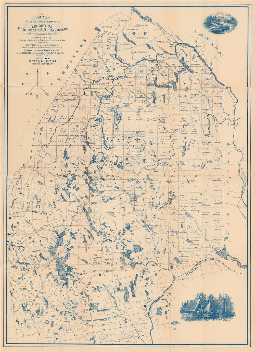
Map of the Headwaters of the Aroostook, Penobscot, and St. John Rivers, Maine.
1881 (dated) 29.5 x 21.5 in (74.93 x 54.61 cm) 1 : 400000
1881 (dated) 29.5 x 21.5 in (74.93 x 54.61 cm) 1 : 400000
Description
This is an 1881 Thomas Sedgwick Steele map of central and eastern Maine. Depicting the state from Penobscot Lake to Grand Lake, this is one of the first maps ever issued with the canoeist in mind. The Aroostook, Penobscot, and St. John rivers appear in fantastic detail, alongside Maine's extensive lake and river system. Moosehead Lake, Maine's largest lake, is situated on the left side. Maine's township grid overlays the state. Township owners are identified, and several towns close to the Canadian border, such as Linneus and Houlton, are labeled as well. The Female Seminary Grant is marked, as is the Middlesex Canal Grant, the Day's Academy Grant, and the Sandwick Academy Grant, among others. Entirely printed with blue ink, the map features two attractive engravings, one of Steele's canoe at the top right and another of his camp at the bottom right. Both of which are based on Steele's paintings.
Publication History and Census
This map was created by Thomas Sedgwick Steele and published in 1881 in his classic narrative of wilderness, Canoe and Camera. We are aware of two different editions of Steele's map, one printed in black and white and another printed in blue, like the present example. Three examples are cataloged in OCLC and are part of the institutional collections at the Connecticut Historical Society, the University of Michigan, and the Osher Map Library at the University of Southern Maine. However, it is unknown whether these examples represent the black and white edition or the blue edition.Cartographer
Thomas Sedgwick Steele (June 11, 1845 - September 9, 1903) was an American outdoorsman, writer, photographer and artist active in the latter half of the 19th century. Steele was born in Hartford Connecticut on June 11, 1845. As a young man he partnered with his father and established himself as a jeweler. While enjoying mild success in this profession, Steele's real passions were writing, painting, drawing. Steele published his first books, "Canoe and Camera" and "Paddle and Portage" in the early 1880s. These, like all of Steele's works were lavishly illustrated with engravings derived from his own paintings. They were also issued with a map of some historical importance as it represented one of the first maps ever created specifically with canoeists in mind. Steele formally gave up the jewelry business in 1887 to pursue his artistic passions. He went on to join the Boston Art Club, study in Paris with Marcius Sidmonds, and travel throughout Europe and North Africa. As an artist Steele developed a realist style and most of his work focused wildlife (specifically fish) and still life images of fruit. He is also known to have dabbled in impressionism and luminism, but neither style inspired him. Though he married twice, Steele fathered no known children. He died in Swampscott, MA on September 9th, 1903. More by this mapmaker...
Source
Steele, T. S., Canoe and Camera or Two Hundred Miles Through The Maine Forests, Illustrated. (New York: Orange Judd and Co.) 1881.
Condition
Very good. Some wear on old fold lines.
References
OCLC 53285584.