This item has been sold, but you can get on the Waitlist to be notified if another example becomes available, or purchase a digital scan.
1936 F. M. S. Map of Portuguese and Dutch Fortifications, Malacca
Malacca-fms-1936$200.00

Title
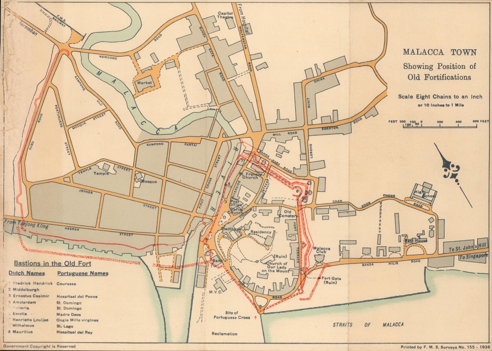
Malacca town, Showing position of old fortifications.
1936 (dated) 7.25 x 10 in (18.415 x 25.4 cm) 1 : 6336
1936 (dated) 7.25 x 10 in (18.415 x 25.4 cm) 1 : 6336
Description
An intriguing 1936 map of Malacca (Melaka) highlighting the location of historic sites, especially fortifications, produced by the Survey Department of the Federated Malay States (FMS). Although Malacca had been under British control for more than a century by this point, the city's identity was closely tied to its complex colonial and pre-colonial past.
As a strategically located port in one of the busiest shipping lanes in the world, Malacca has a long history as a crossroads of cultures, trade, and imperial competition. In the early 15th century, support from Admiral Zheng He's 'Treasure Fleets' and Ming China allowed the port, previously insignificant, to become an important entrepôt. A century later, a Portuguese force sent from Goa conquered Malacca, and in turn, in 1641, the Dutch captured the city and ruled it for a century and a half. Finally, in 1824, Malacca was ceded to the British East India Company in exchange for Bencoolen, Sumatra. After the company was dissolved, Malacca became a crown colony and joined the Straits Settlements.
The British recognized the value of Malacca's location for controlling the Strait of Malacca, but like the Portuguese and Dutch they were not especially interested in prioritizing it as a commercial port, focusing instead on Penang and Singapore. Like those two port cities, Malacca was a quintessential outpost of the British Empire, with a small population of Europeans and mixed race 'Eurasians' forming an elite, and the bulk of the population consisting of Chinese, Indians, and Malays.
A Closer Look
Possibly intended for tourists, this map points out the location of historic Portuguese and Dutch fortifications (outlined in red), churches, ruins, and other sites throughout the city. Structures that existed under both empires have their Portuguese and Dutch names indicated, reflecting the layered history of the city. Even in recent years, construction projects have unearthed additional ruins and fortifications, such as the 2006 discovery of a portion of the Middelburg Bastion along the Malacca River.As a strategically located port in one of the busiest shipping lanes in the world, Malacca has a long history as a crossroads of cultures, trade, and imperial competition. In the early 15th century, support from Admiral Zheng He's 'Treasure Fleets' and Ming China allowed the port, previously insignificant, to become an important entrepôt. A century later, a Portuguese force sent from Goa conquered Malacca, and in turn, in 1641, the Dutch captured the city and ruled it for a century and a half. Finally, in 1824, Malacca was ceded to the British East India Company in exchange for Bencoolen, Sumatra. After the company was dissolved, Malacca became a crown colony and joined the Straits Settlements.
The British recognized the value of Malacca's location for controlling the Strait of Malacca, but like the Portuguese and Dutch they were not especially interested in prioritizing it as a commercial port, focusing instead on Penang and Singapore. Like those two port cities, Malacca was a quintessential outpost of the British Empire, with a small population of Europeans and mixed race 'Eurasians' forming an elite, and the bulk of the population consisting of Chinese, Indians, and Malays.
Publication History and Census
This map was produced by the Survey Department of the Federated Malay States in 1936. It is not known to be held by any institution and has no known history on the market. A 2011 doctoral dissertation about the A Famosa Ruins, likely the site indicated here as 'Fort Gate (Ruin),' refers to a map of the same title and year published by the Malacca Historical Society, perhaps as part of a 1936 book titled Historical guide of Malacca. However, that reference does not mention the Survey Department, leading to some uncertainty about the relationship between the two maps.Cartographer
Federated Malay States Survey (1922 - 1945), better known as the F.M.S. Survey Department, was established in the early 20th century to produce detailed surveys of British Malaya and the Straits Settlements. The survey department had offices in most major Malayan ports, including Singapore, Kuala Lumpur, Penang (Georgetown), and Malacca. They were the first official survey organization to publish detailed scientifically produced maps of the region. More by this mapmaker...
Condition
Good. Wear along fold lines. Creasing and wear at left.
References
Mohamad Izani Zainal Abidin, 'Conjectural Reconstruction of the A Famosa Fortress in Melaka' (Ph.D. Dissertation: University of Strathclyde, Glasgow, 2011), p. 97 et passim.