This item has been sold, but you can get on the Waitlist to be notified if another example becomes available, or purchase a digital scan.
1783 Bohn and Valentijn Map of Singapore, Malaya, and Sumatra
MalayaSingaporeSumatra-bohnzoon-1783$1,750.00

Title
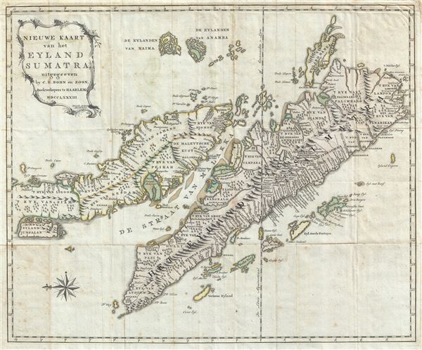
Nieuwe Kaart van het Eyland Sumatra, uitgegeeven by C. H. Bohn en Zoon, Boekverkopers te Haaarlem MDCCLXXXIII.
1783 (dated) 19 x 23 in (48.26 x 58.42 cm) 1 : 3326400
1783 (dated) 19 x 23 in (48.26 x 58.42 cm) 1 : 3326400
Description
A fine engraved 1783 map of the Malay Peninsula, Singapore, the Straits of Malacca, and Sumatra by Christoph Heinrich Bohn. Oriented to the east, Bohn's map covers from the Island of Junsalan (Penang / Prince of Wales Island / Pulu Pinang) south as far as the Straits of Sunda and west to Atsjien (Banda Aceh) at the western tip of Sumatra. It extends eastwards to the Anambas Islands and the Bangka-Belitung Islands. Topography is rendered in profile. The map also offers limited submarine detail through the Strait of Malacca. Several small towns, most notably Soengei Pao, appear in the vicinity of modern day Kuala Lumpur. Johor is identified as Djohor. The island of Singapore is presented but not named.
Cartographically this map is derived from the 1726 map of Francois Valentijn. Francois Valentijn (1666–1727) was a minister, naturalist and writer who is best known for his Oud en Nieuw Oost-Indien (Old and New East-India), a history of the Dutch East India Company (VOC) and their activities in the East Indies. Valentijn's maps were among the most accurate and large scale productions detailing the East Indies thus far published. As VOC officer, Valentijn doubtless had access to VOC manuscript records which he complied into his remarkable collection of maps. In fact, Valentijn's maps are so superior to previous maps that their publication itself is rather surprising. The VOC's policy of extreme secrecy, especially regarding cartographic matters, historically limited publication of their charts.
By the time Bohn published this map, in 1783, the VOC had somewhat relaxed its policy of secrecy. Nonetheless, Valentijn's map remained the standard and it is upon this work that he based his own map. Bohn's map is not, however, a slavish copy and is a wholly new engraving featuring several important updates. These are primarily focused on the arrangement of cities and districts, and correction of names, in southwestern Sumatra. Eyland Junsalan, or modern day Penang, is overlarge. Bohn further added a decorative cartouche of a rococo ethic.
This map was published by Bohn en Zoon (Bohn and Sons) in Amsterdam and engraved by Krevelt for publication in Schirach and Eschelskroon's 1783 Beschryving van het Eiland Sumatra. Both the book and this map are exceedingly scarce. We have found no other examples offered for sale, or ever offered, and only a few examples of the book itself in institutional collections. A once in a lifetime collecting opportunity.
CartographerS
Christoph Heinrich Bohn (1755 - 1785) was a Dutch engraver active in Haarlem during the second half of the 18th century. Bohn's imprint Bohn en Zoon (John and Sons) also includes his son Francois Haarlem Bohn (1781 - 1819). More by this mapmaker...
Francois Valentijn (April 17, 1666 - August 6, 1727) was a Dutch minister, naturalist, colonial administrator, and historian active in Holland and the East Indies, in the late 17th and early 18th centuries. Valentijn was born in Dordrecht, Holland and studied at the Universities and Leiden and Utrecht before, in 1685, taking a position with the Dutch East India Company (VOC). He remained in the East Indies for about 10 years before returning to Dordrecht. Unable to adjust to life in Europe, he returned to the East Indies in 1705 where he remained for another 9 years. After 19 total years in the Orient working for the VOC, Valentijn once again returned to Holland where he composed his eight volume five part masterwork Oud en Nieuw Oost-Indien. The scope and detail of this work, including over 1000 engraved images and numerous maps was unprecedented with regards to Asia. The work contained some of the finest and most detailed large scale maps of the East Indies ever published. The most important of these focus on Taiwan and Malaya. Valentijn most likely drew on secret VOC manuscript maps and documents, a fact that makes it exceptionally surprising that his works were actually published. Valentijn academic scholarship, in sharp contrast to his cartographic work, is often highly criticized as being self-aggrandizing and, more often than not, plagiarized. Learn More...
Source
Eschelskroon, A., and Schirach, G. B. von, Beschryving van het eiland Sumatra. Inzonderheid ten aanzien van deszelfs koophandel, en de voornaamste merkwaardigheden, die eenige betrekking tot dezelve hebben. Benevens eene origineele kaart van dat eiland, door den Heer Adolph Echels-Kroon ... in 't Hoogduitsch uitgegeeven en met eene voorrede verrykt, door den Herr Gottlob Benedict von Schirach ... Waar by gevoegd is een aanhangzel, behelzende eene beknopte beschryving der eilanden Borneo, Banda, Amboina en Ceylon ..., (Haarlem, C. H. Bohn en Zoon) 1783.
Condition
Very good. Original fold lines exhibit slight wear. Minor closed tear extending 1 inch into the paper, upper right corner. Minor tape upper margin, verso, from previous framing work.
References
Yale University, Beinecke, Nff86 I61 783Ep.