1727 Valentijn Map of Malaysia and Sumatra (Singapore)
MalayaSumatra-valentijn-1726$2,000.00

Title
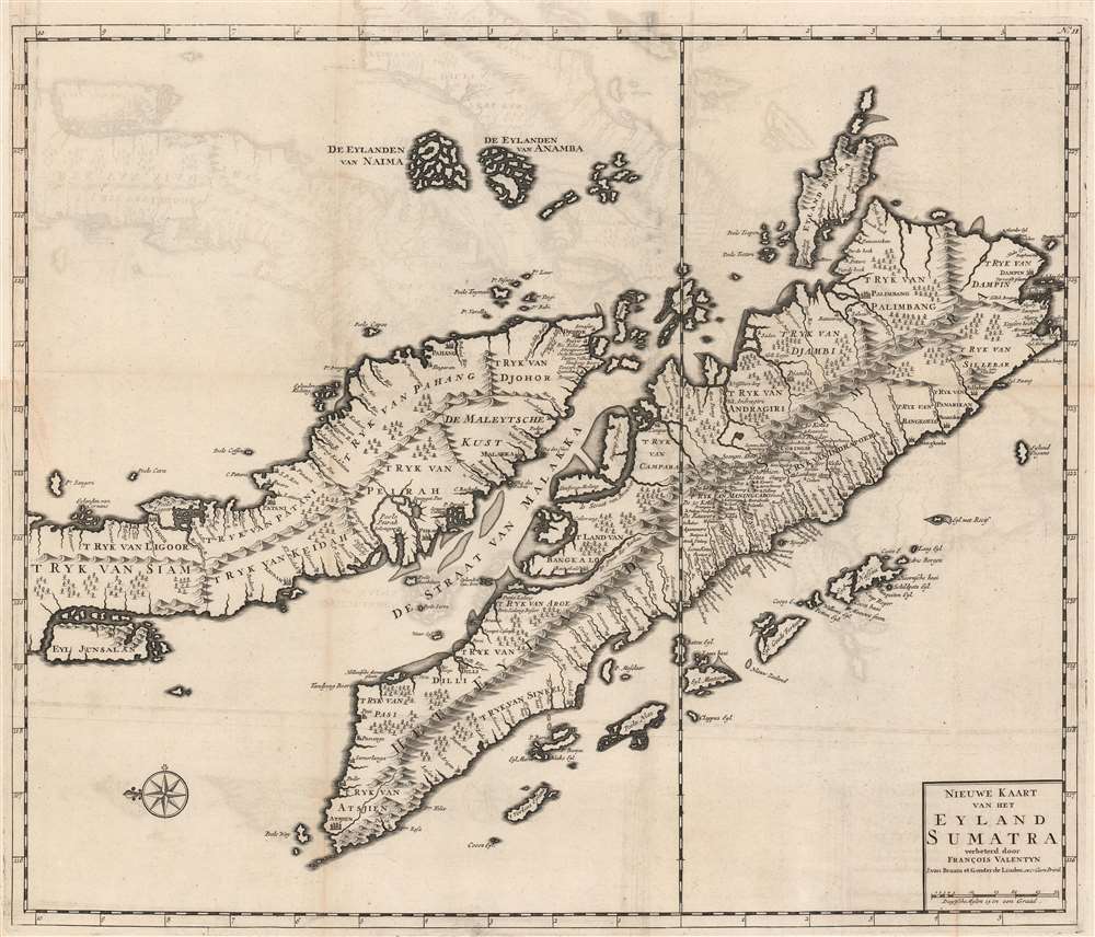
Nieuwe Kaart van het Eyland Sumatra verbeterd door Francois Valentyn.
1726 (undated) 20.5 x 24.5 in (52.07 x 62.23 cm) 1 : 3000000
1726 (undated) 20.5 x 24.5 in (52.07 x 62.23 cm) 1 : 3000000
Description
This is a superb example of Francois Valentijn's 1726 map of Malaya (Malaysia and Singapore) and Sumatra. This is the earliest published map to present a sophisticated treatment of Malaya and Sumatra, and the model upon which most subsequent maps through the late 18th century were based. It is, moreover, one of the earliest maps to expound upon the indigenous polities of Malaya.
A Closer Look
Oriented to the east, Valentijn's map covers from the Island of Junsalan (Penang / Prince of Wales Island / Pulu Pinang) south as far as the Straits of Sunda and west to Atsjien (Banda Aceh) at the western tip of Sumatra. It extends eastwards to the Anambas Islands and the Bangka-Belitung Islands. The cartographer identifies various polities as well as numerous coastal settlements and cities. Topography is rendered in profile with hydrographic content present in the Strait of Malacca. Valentijn identifies seven separate kingdoms within the peninsula.Historical Context
The presentation thus represents a major change in Malayan politics following the Dutch capture of Portuguese Malacca in 1606. The Dutch forged a peaceful arrangement with the Sultan of Johor, leading to peace and prosperity in the region. This prosperity, combined with the decline of the Sunnite of Aceh in northern Sumatra, allowed for the rapid development and expansion of smaller polities throughout the peninsula, including Johor, Perak, Pahang, Patani, Kedah, and Ligor - the latter two of which, as noted here, fell under the sway of Siam. Valentijn, moreover, has recorded some 80 place names in Malaya alone and far more in Sumatra, surpassing all predecessor maps.Publication History and Census
This map was issued in Amsterdam in Francois Valentijn's 1726 Oud en nieuw Oost-Indien. It was published by Joannes van Braam and Gerard onder de Linden, whose names appear on the imprint. Today this important map is very scarce.Cartographer
Francois Valentijn (April 17, 1666 - August 6, 1727) was a Dutch minister, naturalist, colonial administrator, and historian active in Holland and the East Indies, in the late 17th and early 18th centuries. Valentijn was born in Dordrecht, Holland and studied at the Universities and Leiden and Utrecht before, in 1685, taking a position with the Dutch East India Company (VOC). He remained in the East Indies for about 10 years before returning to Dordrecht. Unable to adjust to life in Europe, he returned to the East Indies in 1705 where he remained for another 9 years. After 19 total years in the Orient working for the VOC, Valentijn once again returned to Holland where he composed his eight volume five part masterwork Oud en Nieuw Oost-Indien. The scope and detail of this work, including over 1000 engraved images and numerous maps was unprecedented with regards to Asia. The work contained some of the finest and most detailed large scale maps of the East Indies ever published. The most important of these focus on Taiwan and Malaya. Valentijn most likely drew on secret VOC manuscript maps and documents, a fact that makes it exceptionally surprising that his works were actually published. Valentijn academic scholarship, in sharp contrast to his cartographic work, is often highly criticized as being self-aggrandizing and, more often than not, plagiarized. More by this mapmaker...
Source
Valentijn, F., Oud en Nieuw Oost-Indien, (Dordrecht: J. van Braam) 1726.
Condition
Very good. Crisp dark impression suggestive of an early strike off the plate. Original platemark visible. Left margin expertly extended where originally joined to volume. Minor verso repair same area. Blank on verso.
References
Curtis, R. and Durand, Fr., Maps of Malaysia and Borneo: Discovery, Statehood and Progress, pages 49-50, no. 38. OCLC 871359842.