1955 Survey Department Map of Malay Peninsula, Malaysia, Singapore
MalayPeninsula-surveydeptmalaya-1955$125.00

Title
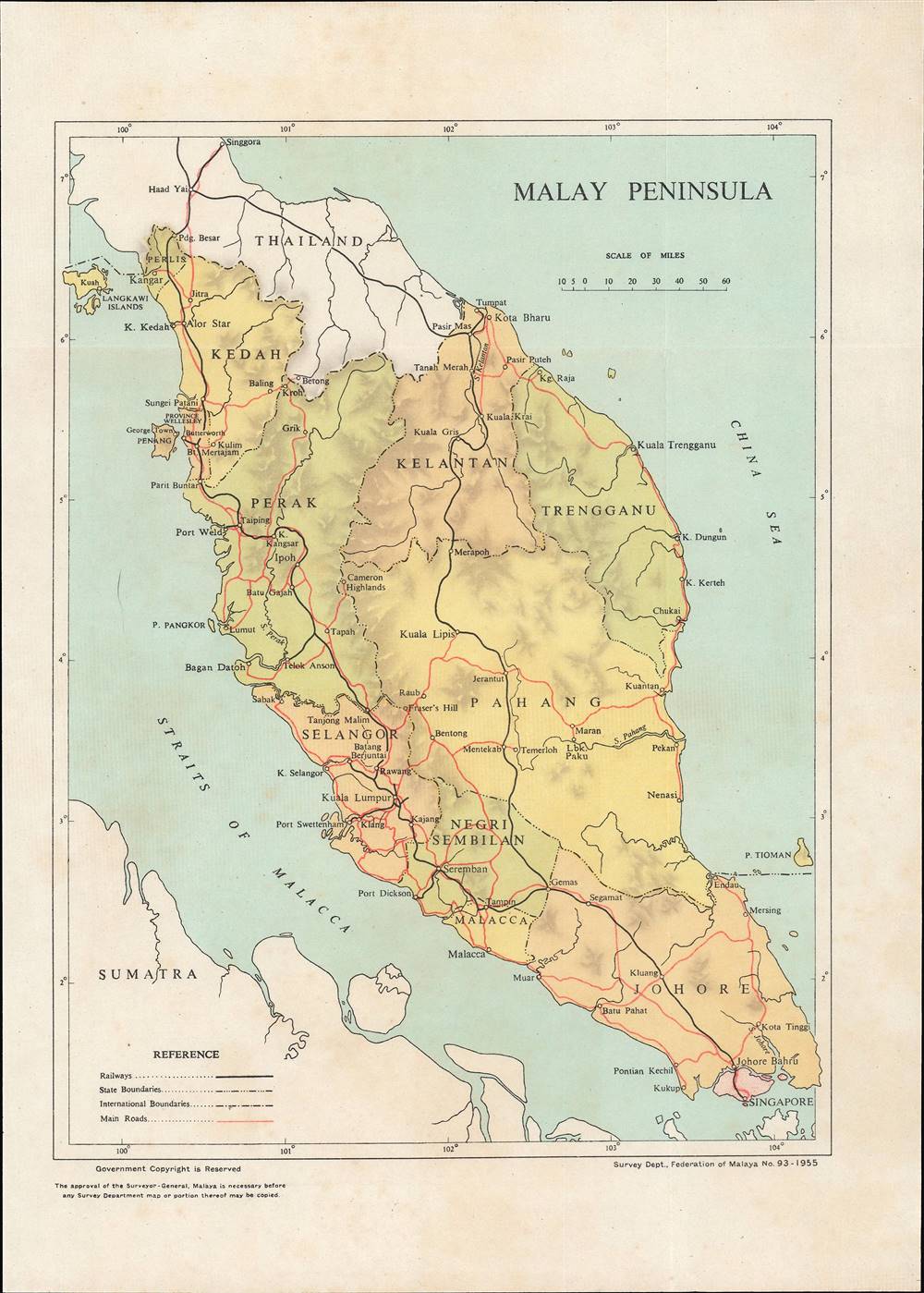
Malay Peninsula.
1955 (dated) 10.25 x 7.5 in (26.035 x 19.05 cm) 1 : 3000000
1955 (dated) 10.25 x 7.5 in (26.035 x 19.05 cm) 1 : 3000000
Description
This is a 1955 map of the Malay Peninsula and Singapore made by the Survey Department of the Federation of Malaya. It depicts the country on the eve of its independence from Great Britain, which was a relatively smooth transition.
Aside from administrative boundaries, roads and railways are indicated here, highlighting the paucity of infrastructure in the north and east of the country. The limited number of roads and railways running north and south down the peninsula had been an important factor in Japan's rapid conquest of Malaya in late 1941 and early 1942, and they were equally important in the 'Malayan Emergency,' which was ongoing when this map was made. The handful of roads were ripe spots for ambushes by Communist insurgents, which led to widespread use of herbicides and defoliants by the British to remove roadside vegetation, making it difficult for insurgents to launch attacks.
Malaya was an important piece in Britain's global empire, especially as a source of tin and rubber. This fact also made the peninsula a target for a Japanese invasion in late 1941. Britain's defense of the peninsula was disastrous, culminating in the embarrassing surrender of Singapore, smashing the façade of British military invincibility. The occupation was trying for all inhabitants of Malaya, especially ethnic Chinese communities who suffered wholesale massacres at the hands of Japanese troops.
After the war, as elsewhere, Britain found it difficult to reassert control and was forced to undertake moves towards independence. The war and the immediate postwar situation had pushed the states and colonies towards a federal union, which adopted a Westminster parliamentary system and a fixed-term monarch that rotated among the rulers of the various constituent states.
The independence of the Federation (1957) and creation of Malaysia (1963) were heavily influenced by Cold War geopolitics. Britain was aided in its plan of gradual drawdown by the recklessness of the most militant independence activists and rebels, led by Communists, who repeatedly committed terrorist attacks that alienated the population and justified a continued British military presence. The defeat of the Communists in the 'Malayan Emergency' came to be seen as a model 'counter-insurgency,' though attempts to repeat its success elsewhere have failed.
With the Communists on the back foot by 1955, and with a new Prime Minister, Tunku Abdul Rahman, who enjoyed broad public support, Malaya was ready to move towards independence. Although there was intercommunal strife and widespread anti-colonial sentiment, the handoff to independence in Malaya was relatively smooth and the country subsequently maintained closer ties with Britain than Burma or India, including as an anti-communist bulwark in Southeast Asia (the dominant political party of the independence era, the United Malays National Organization, was strongly supported by the British). Still, Malaysia's early history was defined by racial tensions, leading to the expulsion of Singapore only two years into the country's existence, and conflict with Indonesia.
A Closer Look
The map includes the constituent states of the Federation of Malaya, including Penang and Malacca, which had previously been crown colonies and part of the Straits Settlements. Singapore at this point was not a part of the Federation of Malaya but remained a crown colony, albeit one clearly on the road to greater autonomy (it held its first general election in 1955). Soon afterward, the People's Action Party led by Lee Kuan Yew became the dominant force in Singaporean politics and still is today.Aside from administrative boundaries, roads and railways are indicated here, highlighting the paucity of infrastructure in the north and east of the country. The limited number of roads and railways running north and south down the peninsula had been an important factor in Japan's rapid conquest of Malaya in late 1941 and early 1942, and they were equally important in the 'Malayan Emergency,' which was ongoing when this map was made. The handful of roads were ripe spots for ambushes by Communist insurgents, which led to widespread use of herbicides and defoliants by the British to remove roadside vegetation, making it difficult for insurgents to launch attacks.
From Malaya to Malaysia
British Malaya was a combination of quasi-independent protectorates like Kedah (the Unfederated States), more directly controlled but still nominally autonomous Federated States (based in Kuala Lumpur), and the Straits Settlements (Singapore, Penang, Malacca, and Dinding, here as Pangkor Island), which were crown colonies. Though all were enmeshed in a wider colonial system and often considered as part of a single entity, this tripartite system lasted until after the Second World War.Malaya was an important piece in Britain's global empire, especially as a source of tin and rubber. This fact also made the peninsula a target for a Japanese invasion in late 1941. Britain's defense of the peninsula was disastrous, culminating in the embarrassing surrender of Singapore, smashing the façade of British military invincibility. The occupation was trying for all inhabitants of Malaya, especially ethnic Chinese communities who suffered wholesale massacres at the hands of Japanese troops.
After the war, as elsewhere, Britain found it difficult to reassert control and was forced to undertake moves towards independence. The war and the immediate postwar situation had pushed the states and colonies towards a federal union, which adopted a Westminster parliamentary system and a fixed-term monarch that rotated among the rulers of the various constituent states.
The independence of the Federation (1957) and creation of Malaysia (1963) were heavily influenced by Cold War geopolitics. Britain was aided in its plan of gradual drawdown by the recklessness of the most militant independence activists and rebels, led by Communists, who repeatedly committed terrorist attacks that alienated the population and justified a continued British military presence. The defeat of the Communists in the 'Malayan Emergency' came to be seen as a model 'counter-insurgency,' though attempts to repeat its success elsewhere have failed.
With the Communists on the back foot by 1955, and with a new Prime Minister, Tunku Abdul Rahman, who enjoyed broad public support, Malaya was ready to move towards independence. Although there was intercommunal strife and widespread anti-colonial sentiment, the handoff to independence in Malaya was relatively smooth and the country subsequently maintained closer ties with Britain than Burma or India, including as an anti-communist bulwark in Southeast Asia (the dominant political party of the independence era, the United Malays National Organization, was strongly supported by the British). Still, Malaysia's early history was defined by racial tensions, leading to the expulsion of Singapore only two years into the country's existence, and conflict with Indonesia.
Publication History and Census
This map was drafted, printed, and published by the Survey Department of the Federation of Malaya in 1955. It is held by the University of California Berkeley, the University of Hawaii at Manoa, the University of Chicago, and the National Library Board, Singapore.Cartographer
Survey Department, Federation of Malaya (1885 - present), today the Department of Survey and Mapping Malaysia (Jabatan Ukur dan Pemetaan Malaysia, abbreviated as JUPEM), has origins in the Department of Survey, Johor, established in 1885. The survey departments of the various states and settlements of Malaya were gradually merged and formally placed under a single administration upon independence in 1957, though to this day JUPEM is divided into units according to state that are generally successors to the former survey departments of the individual states. More by this mapmaker...
Condition
Very good.
References
OCLC 230655623.