1827 Map of the Maldive Archipelago
Maldives-vandermaelen-1827$500.00

Title
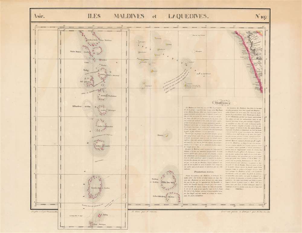
Iles Maldives et Laquedives. Asie. no. 107.
1827 (undated) 20 x 21.75 in (50.8 x 55.245 cm) 1 : 1641836
1827 (undated) 20 x 21.75 in (50.8 x 55.245 cm) 1 : 1641836
Description
This is the rare 1827 Vandermaelen map of the Indian Ocean archipelagoes of the Maldives and the Laccadive Islands. It is the first map to specifically focus on these islands. The map of the Maldives - presented as an inset extension of the main map - illustrates the chain of lagoons in sharper detail than any other to date. In particular, the map presents two ships' tracks through the Huvadhu Channel. Since this was and is the broadest channel between any other atoll of Maldives. Its identification by the ships Contractor in 1792 and the Fatty Rair in 1795 would make the channel an important feature to highlight. As a matter of contrast, other channels are identified either as 'dangereux' ('dangerous') or 'inconnu' ('unknown'). The secrets of navigating the Maldives had long been the island kingdom's first line of defense - and the discovery of this channel by European powers was the first break in these defenses in more than 300 years. This was among the largest-scale maps of this region produced to date. Vandermaelen's Atlas, by applying a uniform scale to every map, afforded sharper detail to many remote areas of the world previously not so well depicted. This is also the first map of the region executed in lithograph.
Publication History and Census
This map appeared in the second part, 'Deuxième partie, Asie' of Vandermaelen's Atlas universel de géographie physique, politique, statistique et minéralogique. The atlas was produced in one edition in 1827. Only 810 complete sets were sold. The full set of six volumes appears in eleven institutional collections in OCLC. The 2nd volume alone is listed in 11. We do not see any examples of the separate map in institutional collections.Cartographer
Philippe Marie Guillaume Vandermaelen (December 23, 1795 - May 29, 1869) was a Flemish cartographer active in Brussels during the first part of the 19th century. Vandermaelen is created with "one of the most remarkable developments of private enterprise in cartography," namely his remarkable six volume Atlas Universel de Geographie. Vandermaelen was born in Brussels in 1795 and trained as a globe maker. It was no doubt his training as a globe maker that led him see the need for an atlas rendered on a universal scale in order that all bodies could be understood in relation to one another. In addition to his great work Vandermaelen also produced a number of globes, lesser maps, a highly detailed 250 sheet map of Belgium, and several regional atlases. More by this mapmaker...
Source
Vandeermaelen, P., Atlas universel de geographie physique, politique, statistique et mineralogique, (Bruxelles: Vandermaelen) 1827.
Atlas Universel de Geographie. This great work, featuring some 378 unique maps and compiled over three years, was the first lithograph atlas, and the first to render the world on the same projection and at a uniform scale. It was no doubt Vandermaelen’s training a globe maker that led him see the need for an atlas rendered uniformly so that all bodies could be understood in relation to one another. As a result, many newly emerging areas received more attention than prior efforts. Maps of the American West, in particular, benefited: ‘no mapmaker had previously attempted to use such a large scale for any western American area.’ (Wheat). Central and South Asia also appear in sharper focus. Despite Vandermaelen’s reliance upon existing sources, his maps very frequently provided the clearest depictions available of many poorly-understood parts of the world. The atlas was an expensive production, costing $800 in 1827. Subscription lists indicate that only 810 full sets of the atlas were sold. It was printed on high-quality paper with superior hand coloring and was engraved in a clear, legible style. Conjoined, the maps of Vendermaelen's atlas would create a massive globe some 7.75 meters in diameter, a feat which was accomplished at the Etablissement Geographique de Brussels.
Condition
Very good. Filled pinholes to upper margin, else excellent with original wash color.
References
Rumsey 2212.139.