This item has been sold, but you can get on the Waitlist to be notified if another example becomes available, or purchase a digital scan.
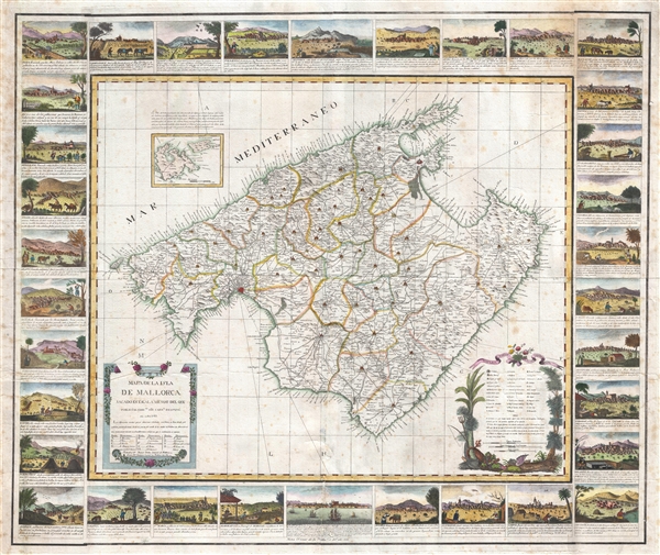
1814 Despuig Map of Majorca, Balaeric Islands, Spain (with surround)
Mallorca-despuig-1814$1,500.00

Title
Mapa de la Isla de Mallorca sacado en escala menor del que publico el E.S. Cardenal Despuig El Año 1785.
1914 (dated) 25 x 30 in (63.5 x 76.2 cm) 1 : 187000
1914 (dated) 25 x 30 in (63.5 x 76.2 cm) 1 : 187000
Description
An exceptionally rare 1814 separately issued boradside map of Majorca, Spain, with fully illustrated surround. The map covers all of Majorca (Mallorca) with an inset nearby islands of Cabrera and Conejara. It is based upon an earlier map surveyed at the order of Cardinal Antonio Despuig y Dameto in 1785. Manuel Briton, Artillery Commissioner revised and reduced the map for sale to tourists in 1814. It was subsequently laid down, engraved, and printed in Palma, Majorca, by Lorenzo María Muntaner (1782-1848). The map is in Spanish, as are the caption on the surrounding views, but the imprint of Briton and Muntaner is in Catalan.
The base map is quite rare and beautiful, but what makes this example special is the decorative surround featuring 34 captioned views of Majorcan cities. This is the only known example to include the views. The OCLC notes only two examples without the views, both located in the Institut Cartografic, Barcelona. For any serious collector of Balearic Islands, this map, published in Palma, an exceptional opportunity.
The base map is quite rare and beautiful, but what makes this example special is the decorative surround featuring 34 captioned views of Majorcan cities. This is the only known example to include the views. The OCLC notes only two examples without the views, both located in the Institut Cartografic, Barcelona. For any serious collector of Balearic Islands, this map, published in Palma, an exceptional opportunity.
Condition
Good. Some foxing. Light creasing. Wear. Printed on 4 sheets, joined by publisher.
References
OCLC 707614400, 707612531.