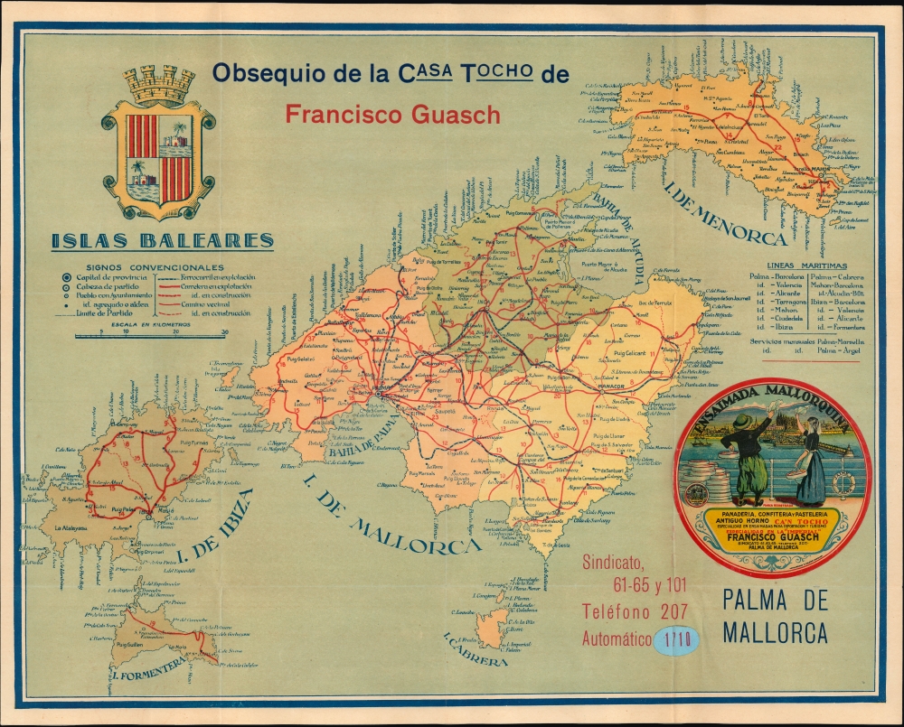
1925 Gausch Map of Mallorca and the Balearic Islands
MallorcaBalearicIs-gausch-1925$350.00


Title
Islas Baleares. / Mapa de comunicaciones de Mallorca.
1925 (undated) 15 x 19 in (38.1 x 48.26 cm) 1 : 360000
1925 (undated) 15 x 19 in (38.1 x 48.26 cm) 1 : 360000
Description
This is an unrecorded c. 1925 chromolithographed promotional map of the Balearic Islands, including Mallorca and Ibiza, produced for the Spanish textile company Gausch.
A Closer Look
The map covers the Balearic Islands, including the now-international tourist destinations of Mallorca and Ibiza. Cities and towns are labeled throughout, including Palma (de Mallorca), the Balearic capital and largest city. Administrative boundaries are traced, and districts (partidos) are color-shaded. Major and minor roads ('country roads' caminos vecinales), both existing and under construction, are traced in red with distances noted, while railways are marked with dashed lines. A table of maritime lines appears at the right, and a sticker of the seal of the Balearic Islands and an advertisement for Mallorcan Ensaïmada, a Gausch pastry product, appears below the table.Gausch
The company today known as Gausch was founded in 1859 by brothers Isaac and Francisco Guasch Pujol in Capellades, some 25 miles from Barcelona. By 1905, the company had expanded considerably, selling textiles internationally and branching into other industries, and relocated many of its operations to Barcelona. The next generation leader of the company, Matías Gausch, oversaw further expansion but faced setbacks when the company's factory was damaged during the Spanish Civil War (1936 - 1939). After the war, Matias and his brother José relaunched the company as Gausch Hermanos S.A., modernizing its practices. The company continues to produce a wide range of textiles but is historically best known for its handkerchiefs and, in more recent years, pajamas.Chromolithography
Chromolithography is a color lithographic technique developed in the mid-19th century. The process involved using multiple lithographic stones, one for each color, to yield a rich composite effect. Oftentimes, the process would start with a black basecoat upon which subsequent colors were layered. Some chromolithographs used 30 or more separate lithographic stones to achieve the desired effect. Chromolithograph color could also be effectively blended for even more dramatic results. The process became extremely popular in the late 19th and early 20th centuries when it emerged as the dominant method of color printing. The vivid color chromolithography produced made it exceptionally effective for advertising and propaganda imagery.Publication History and Census
This map was prepared by an unknown maker and provided as a gift by Gausch. It is undated, but from the style and details present (especially the roads and rail lines), it likely dates to the mid-1920s (the Manacor to Arta rail line was completed in 1921, so it must have been produced after that date). The advertisement on both the map and the cover was printed by Artes Gráficas R. Molero in Barcelona, who very well might have printed the entire map as well (like Gasuch, Molero is still in operation, as Gráficas Molero). In any event, the map is unrecorded in institutional collections, under either the title on the map or the cover title, making this a very rare and perhaps unique item.Condition
Very good. Light wear along original fold lines. Advertising sticker on both map and envelope. Accompanied by original envelope.