1730 Seutter Map of Malta and Gozo with crests
Malta-seutter-1730$2,000.00

Title
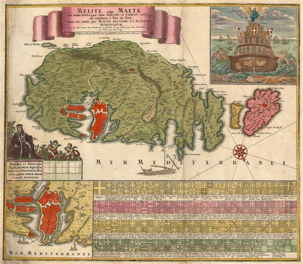
Melite, vulgo Malta cum vicinis Goza, quae olim Gaulos, et Comino insulis / uti exhibetur á Nic. de Fer, nunc aeri incisa per Matth. Seutter, S.C.M. Geogr.
1730 (undated) 19.5 x 22.5 in (49.53 x 57.15 cm) 1 : 150000
1730 (undated) 19.5 x 22.5 in (49.53 x 57.15 cm) 1 : 150000
Description
With this dramatic 1730 map of Malta, Gozo, and Comino, Matthias Seutter celebrates the Venetian victory over the Ottoman Turks in the 1565 Siege of Malta - an event so momentous that even in the 18th century it remained a signal event in European consciousness. Along the bottom of the map are a series of armorial crests representing Grand Masters of the Order of Knights of the Hospital of Saint John of Jerusalem, commonly known as the Knights Hospitaller or the Order of Saint John, a militant monastic order dating to the Crusades.
The Great Siege of Malta
The Great Siege of Malta took place in 1565 when the Ottoman Empire tried to invade the island of Malta, then held by the Knights Hospitaller. The siege lasted four months during the hot summer, resulting in an Ottoman defeat. The numbers of combatants are disputable, varying from 2,000 to 6,000 on the Venetian side versus 30,000 to 40,000 Ottomans. Nevertheless, an island fortress weathering a siege anywhere within this range would merit celebration. Viewed as a turning point in the long war between Christian Venice and the Muslim Ottoman Turks, the Siege became a cause célèbre throughout Western Europe.The Map
The southern-oriented map (after De Fer's exceedingly rare 1722 L'Isle de Malthe,) includes an inset plan of the city and fort of Valleta, and a dramatic view of a Venetian ship sailing triumphantly away, leaving defeated Ottoman sailors floating in its wake. Sixty-eight coats of arms of Maltese knights are displayed below. Fortifications on Malta and Gozo are marked boldly in red.Publication History and Census
This map was engraved by Matthias Seutter and published in Augsburg based upon earlier cartography prepared by Nicolas de Fer. Various editions of this map appear in perhaps two dozen library collections in OCLC.CartographerS
Matthäus Seutter (1678 - 1757) was one of the most important and prolific German map publishers of the 18th century. Seutter was born the son of a goldsmith but apprenticed as a brewer. Apparently uninspired by the beer business, Seutter abandoned his apprenticeship and moved to Nuremberg where he apprenticed as an engraver under the tutelage of the prominent J. B. Homann. Sometime in the early 1700s Seutter left Homann to return to Augsburg, where he worked for the prominent art publisher Jeremiad Wolff (1663 - 1724), for whom he engraved maps and other prints. Sometime around 1717 he established his own independent cartographic publishing firm in Augsburg. Though he struggled in the early years of his independence, Seutter's engraving skill and commitment to diversified map production eventually attracted a substantial following. Most of Seutter's maps are heavily based upon, if not copies of, earlier work done by the Homann and De L'Isle firms. Nonetheless, by 1731/32 Seutter was one of the most prolific publishers of his time and was honored by the German Emperor Karl VI who gave him the title of Imperial Geographer, after which most subsequent maps included the Avec Privilege designation. Seutter continued to publish until his death, at the height of his career, in 1757. Seutter had two engraver sons, Georg Matthäus Seutter (1710 - 173?) and Albrecht Carl Seutter (1722 - 1762). Georg Matthäus quit the business and relocated to Woehrdt in 1729 (and probably died shortly thereafter), leaving the family inheritance to his wastrel brother Albrecht Carl Seutter, who did little to advance the firm until in own death in 1762. Following Albrecht's death, the firm was divided between the established Johann Michael Probst (1727 - 1776) firm and the emerging firm of Tobias Conrad Lotter. Lotter, Matthäus Seutter's son-in-law, was a master engraver and worked tirelessly on behalf of the Suetter firm. It is Lotter, who would eventually become one of the most prominent cartographers of his day, and his descendants, who are generally regarded as the true successors to Matthäus Seutter. (Ritter, M. Seutter, Probst and Lotter: An Eighteenth-Century Map Publishing House in Germany., "Imago Mundi", Vol. 53, (2001), pp. 130-135.) More by this mapmaker...
Nicholas de Fer (1646 - October 25, 1720) was a French cartographer and publisher, the son of cartographer Antoine de Fer. He apprenticed with the Paris engraver Louis Spirinx, producing his first map, of the Canal du Midi, at 23. When his father died in June of 1673 he took over the family engraving business and established himself on Quai de L'Horloge, Paris, as an engraver, cartographer, and map publisher. De Fer was a prolific cartographer with over 600 maps and atlases to his credit. De Fer's work, though replete with geographical errors, earned a large following because of its considerable decorative appeal. In the late 17th century, De Fer's fame culminated in his appointment as Geographe de le Dauphin, a position that offered him unprecedented access to the most up to date cartographic information. This was a partner position to another simultaneously held by the more scientific geographer Guillaume De L'Isle, Premier Geograph de Roi. Despite very different cartographic approaches, De L'Isle and De Fer seem to have stepped carefully around one another and were rarely publicly at odds. Upon his death of old age in 1720, Nicolas was succeeded by two of his sons-in-law, who also happened to be brothers, Guillaume Danet (who had married his daughter Marguerite-Geneviève De Fer), and Jacques-François Bénard (Besnard) Danet (husband of Marie-Anne De Fer), and their heirs, who continued to publish under the De Fer imprint until about 1760. It is of note that part of the De Fer legacy also passed to the engraver Remi Rircher, who married De Fer's third daughter, but Richer had little interest in the business and sold his share to the Danet brothers in 1721. Learn More...
Source
Seutter, M., Grosser Atlas (Augsburg: Seutter) 1730.
Condition
Fair. Expertly remargined on both left and right with manuscript reinstatement to border.
References
OCLC 159823404. Nick Kanas, Star Maps: History, Artistry, and Cartography, 170-1. Solder and Ganado, Charting Maltese Waters, ch. 5.