This item has been sold, but you can get on the Waitlist to be notified if another example becomes available, or purchase a digital scan.
1922 Fairchild Aerial Photo Survey of Manhattan and the Bronx, NEW YORK
Manhattan-fairchildaerial-1922$750.00

Title
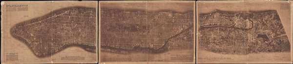
Aerial Survey of Manhattan and the Bronx.
1922 (dated) 21 x 98 in (53.34 x 248.92 cm) 1 : 11200
1922 (dated) 21 x 98 in (53.34 x 248.92 cm) 1 : 11200
Description
This is a rare 1922 triptych aerial survey map of Manhattan Island, New York, prepared by the Fairchild Aerial Camera Corporation. This is mostly likely either the first or second aerial survey of a major city – the other being Fairchild's survey of Newark in the same year. This view covers all of Manhattan Island as well as adjacent parts of the Bronx. The leftmost sheet detail lower Manhattan to 60th Street. The second map covers from 60th Street to 160th Street. The third map extends from 160th street well into the Bronx as far as Woodhaven cemetery. Important locations are labeled throughout.
These maps were photographed use Sherman Fairchild's patented interval aerial camera. The camera, which was mounted under a bi-plane, automatically took photographs at fixed intervals which could then be joined to create a comprehensive exact aerial image of a city. The present example was made from some 100 photographs taken in a single flight from about 1000 feet.
This view is quite rare. The Library of Congress owns a similar view, doubtless a precursor of the present example, which it dates to 1921. The present example was issued in three parts by the New York Evening Post's Saturday Graphic on April 8, 15, and 22, consecutively.
Cartographer
Sherman Mills Fairchild (April 7, 1896 – March 28, 1971) was an American inventor, entrepreneur, pilot, and photographer active in New York in the first half of the 20th century. He was the son of George Winthrop Fairchild, a Republican Congressman and Co-Founder of IBM. He inherited his father's vast estate in 1924, becoming IBM's largest shareholder. After studying at Harvard, the University of Arizona, and Columbia University, Fairchild invented the synchronized camera shutter and flash – a significant advancement in photography. Sherman was chronically in poor health, nonetheless, when World War I broke out he volunteered for the military. Due to his health, he was rejected by the military, so he decided to contribute to the war effort in another way. He took a contract with the U.S. Government to develop a new kind of aerial camera capable of taking sequentially timed photographs for advanced aerial terrain mapping. This invention led to the founding of the Fairchild Aerial Camera Corporation (later the Fairchild Camera and Instrument Company) in 1920. In 1921, he purchased a surplus World War I Fokker D. VII biplane and expanded with his own aerial survey company, Fairchild Aerial Surveys. His first map, the first aerial photo-survey of a major city, was of Newark, New Jersey. This was quickly followed by a large aerial survey of Manhattan, also completed in 1921. Other cities followed. Later the Fairchild Corporation developed even more advanced cameras, including the Fairchild Lunar Mapping Camera, used by NASA to take photos of the Moon from orbit. He also founded Fairchild Aviation Corporation, which built the FC-1 and FC-2 Aircraft. The firm went on to become one of the largest military and defense contractors in the world. Fairchild died in 1971, leaving behind a $200+ million dollar estate to varies charities and foundations. More by this mapmaker...
Source
New York Evening Post, 'Saturday Graphic', April 8, 15, and 22, 1922.
Condition
Average. Sepia tone. Backed on old linen. Some chipping here and there throughout. Brittle. Measurement represets three sheets.
References
Library of Congress 90680339. OCLC 881836679.