This item has been sold, but you can get on the Waitlist to be notified if another example becomes available, or purchase a digital scan.
1939 Geographia City Map or Plan of Manhattan, New York City
Manhattan-geographia-1939$600.00


Title
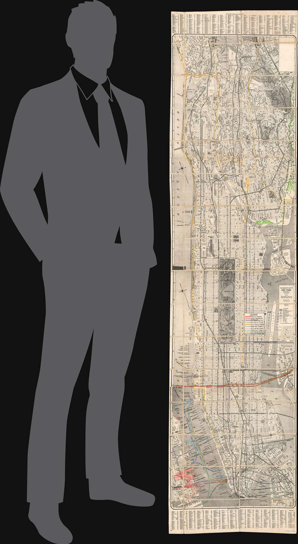
The Complete Map of New York (Manhattan) Featuring House Numbers, Transit Lines, Playgrounds, Wading Pools, etc.
1939 (dated) 71.5 x 17.5 in (181.61 x 44.45 cm) 1 : 24000
1939 (dated) 71.5 x 17.5 in (181.61 x 44.45 cm) 1 : 24000
Description
This is a unique c. 1939 Geographia city plan or map of Manhattan, New York City with extensive manuscript annotation relating to the infrastructure and operations of the Pennsylvania Railroad. The map’s coverage includes all of Manhattan, as well as adjacent portions of Jersey City, Brooklyn, and the Bronx. The I.R.T., B.M.T., and Independent subway lines are identified.
All other railroads with terminals along the Hudson, no matter if they were in Jersey City or Hoboken, offered connections between New Jersey and New York City via ferry. These terminals are illustrated along the left side of the map, although not all of them are present. The ferry lines are noted by dashed lines of varying colors to highlight the different routes and piers used by the different railroads. Coincidentally, only two railroads cross the East River into Queens: the Lehigh Valley Railroad and the New York, New Haven and Hartford Railroad, which operated over tracks owned by the Pennsylvania Railroad.
Manuscript Railroad Lines
Focusing on the Hudson River, eleven railroad lines and their associated ferry crossings are illustrated in manuscript, including the Pennsylvania Railroad, the New York Central Railroad, and the Delaware, Lackawanna and Western Railroad. Only one of these railroads, the New York Central, was founded in New York City, and only two, the Pennsylvania and the Hudson and Manhattan, had successfully constructed tunnels under the Hudson River to provide direct service into New York City from New Jersey. The Pennsylvania, marked here in solid red lines, completed its North River Tunnels in 1910 and began running service into the newly constructed Penn Station on 34th Street that same year over electrified lines under the river. The Hudson and Manhattan, highlighted by light purple lines, began running passenger service between Hoboken Terminal and 19th Street on February 26, 1908.All other railroads with terminals along the Hudson, no matter if they were in Jersey City or Hoboken, offered connections between New Jersey and New York City via ferry. These terminals are illustrated along the left side of the map, although not all of them are present. The ferry lines are noted by dashed lines of varying colors to highlight the different routes and piers used by the different railroads. Coincidentally, only two railroads cross the East River into Queens: the Lehigh Valley Railroad and the New York, New Haven and Hartford Railroad, which operated over tracks owned by the Pennsylvania Railroad.
Publication History and Census
This map is most likely one of a kind. While the base map was published by Geographia in 1939 and was commercially available, it was repurposed by the Pennsylvania Railroad to illustrate key infrastructure improvements and assist with the administration of railroad routes and ferries. Examples of the base map are present in a half dozen institutional collections, but we have not located any other known examples of the present map with its extensive depiction of the railroad routes in and around Manhattan.Cartographer
Geographia, Ltd. (1911 - 1985) was a London-based cartographic publishing firm. The company was founded by Alexander Gross (1879 - 1958), a Hungarian immigrant to the United Kingdom. Geographia Ltd. is best known for its folding pocket maps and globes. Many of his maps were drawn by a mysterious 'Mr. Fountain', of whom we have been able to discover little. Gross ran into financial problems around 1940, likely associated with World War II, and relocated to offices in New York at 11 John Street. There, he issued a large corpus of U.S.-focused maps and city plans. By the 1940s, the branch in the United States had been renamed the Geographia Map Company and experienced rapid growth. By the 1950s, Geographia had published maps of dozens of cities across the United States. In 1987, the British branch was bought out by Harper Collins and continues to produce maps under the Collins Bartholomew imprint. Rand McNally bought the New York-based Geographia Map Company in the late 1980s. However, its original owners repurchased the Geographia Map Company a few years later and still operate the company in Hackensack, New Jersey. Gross's daughter, Phyllis Isobella Gross / Pearsall (1906 - 1996), founded the Geographers' A-Z Map Company in London, the largest independent map publisher in the United Kingdom. In the UK, their offices were originally at 33 Strand, where they published as 'Geographia Designing and Publishing Company Ltd.'. Later, by 1933, they had relocated to 55 Fleet Street, where they remained until at least 1937. By 1942, they relocated to 167 Fleet Street, followed by 114 Fleet Street by 1964. It is of note that many of the Geographia Ltd. maps feature a peculiar dating system wherein the letters in the world CUMBERLAND correspond to the numbers 1234567890, such that a date is rendered by substitution, so A.MU would break out like this A = 8, M = 3, U = 2, so 8.32 or, August 1932. Or, MM.YY e.g. E.MC = 5.31 = May 1931. More by this mapmaker...
Condition
Very good. Even overall toning. Dissected and mounted on linen in 48 panels. Blank on verso.
References
OCLC 880824688.